| | Thumbnail | | Creator | Date | Title / Author / Date / Location | Price | | | Description |
| 385 | 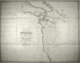 | Details | Parry, William Edward | 1824 |
| Chart of a part of the North Eastern Coast of America [North] |
|
Parry, William Edward |
|
| 1824 |
| LOC:53 |
| $450.00 | Parry--William-Edward | Chart-of-a-part-of-the-North-Eastern-Coast-of-America-[North] | A large chart of the Melville Peninsula and its adjacent islands, including Amherst, Liddon, and Ormond Islands. The chart documents the expedition of the vessels Fury and Hecla from 1822-1823 led by William Edward Parry to find a Northwest passage to the Pacific. Contains the route of the expedition's ships with Cape Englefield and Cape Hallowell off the Fury and Hecla strait as the western-most point. <BR> </BR>
Foldout steel engraving from: "Journal of a second voyage for the discovery of a north-west passage from the Atlantic to the Pacific; performed in the years 1821-22-23, in his Majesty's ships Fury and Hecla, under the orders of William Edward Parry, … ". Published by John Murray, Albemarle Street, London. January 6th, 1824. |
| 386 |  | Details | Parry, William Edward | 1824 |
| Chart of the Northern Shore of Hudson's Strait |
|
Parry, William Edward |
|
| 1824 |
| LOC:53 |
| $400.00 | Parry--William-Edward | Chart-of-the-Northern-Shore-of-Hudson-s-Strait | A large chart of upper Hudson's Strait from Nottingham Island to Resolution Island. The chart documents the expedition of the vessels Fury and Hecla from 1821-1823 led by William Edward Parry to find a Northwest passage to the Pacific. During that expedition Parry explored Repulse Bay and discovered what is now Fury and Hecla Strait. Contains the route of the expedition's ships. <BR> </BR>
Foldout steel engraving from: "Journal of a second voyage for the discovery of a north-west passage from the Atlantic to the Pacific; performed in the years 1821-22-23, in his Majesty's ships Fury and Hecla, under the orders of William Edward Parry, … ". Published by John Murray, Albemarle Street, London. January 6th, 1824. |
| 387 | 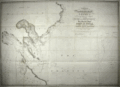 | Details | Parry, William Edward | 1824 |
| Chart of a part of the North Eastern Coast of America [South] |
|
Parry, William Edward |
|
| 1824 |
| LOC:53 |
| $450.00 | Parry--William-Edward | Chart-of-a-part-of-the-North-Eastern-Coast-of-America-[South] | A large chart of Northeastern America with Repulse Bay as the Western-most point.. The chart documents the expedition of the vessels Fury and Hecla from 1821-1822-1823 led by William Edward Parry to find a Northwest passage to the Pacific. During that expedition Parry explored Repulse Bay and discovered what is now Fury and Hecla Strait. Other geographical features on this chart include Cape Frigid, Duke of York Bay, Frozen Strait, Gore Bay, Ross Bay, and Lyon Inlet. <BR> </BR>
Foldout steel engraving from: "Journal of a second voyage for the discovery of a north-west passage from the Atlantic to the Pacific; performed in the years 1821-22-23, in his Majesty's ships Fury and Hecla, under the orders of William Edward Parry, … ". Published by John Murray, Albemarle Street, London. January 6th, 1824. |