| | Thumbnail | | Creator | Date | Title / Author / Date / Location | Price | | | Description |
| 5291 | 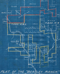 | Details | Parsons, A.F. | 1921 |
| Unrecorded cyanotype plat Beasley Ranch San Luis Obispo, California |
|
Parsons, A.F. |
|
| 1921 |
| LOC:3 |
| $475.00 | Parsons--A-F- | Unrecorded-cyanotype-plat-Beasley-Ranch-San-Luis-Obispo--California | Unrecorded cyanotype (blueprint) cadastral map of the Beasley Ranch in San Luis Obispo County, California. In 1921 the Beasley Ranch was owned by R.K. Smith. Manuscript outline coloring to differentiate the Beasley Ranch in yellow, from property owned by Eckstine in red.
<br></br>
The Beasley Ranch, at the junction of the Nacimiento River and Burnett Creek, was named for William F. Beasley, a native Californian from Mariposa County, CA. Neighboring property is recorded for Joshua Wood, Alice Lynch, Luther Hester, Sands, Harris, Wheeler, Knox, Eckstine, and others.
<br></br>
Survey of the Beasley Ranch was conducted by Austin F. Parsons in October, 1921. Parsons (b. 1853), was San Luis Obispo County Surveyor from 1902 to 1930. Parsons was the Civil Engineer for numerous area bridges including the California Canyon Bridge and San Juan Bridge.
<br></br>
Scale 1" = 40 chains ( 1/2 mile). T.25S R.8E. |