| | Thumbnail | | Creator | Date | Title / Author / Date / Location | Price | | | Description |
| 4732 | 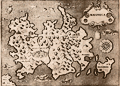 | Details | Porcacchi, Tomasso | 1572 |
| Very old antique map of Mallorca, Spain |
|
Porcacchi, Tomasso |
|
| 1572 |
| LOC:4 |
| $0.00 | Porcacchi--Tomasso | Very-old-antique-map-of-Mallorca--Spain | SOLD
<br></br>Authentic copperplate-engraved antique map (1572) of Maiorica (Mallorca, Majorca), Spain engraved by Girolamo Porro and drawn by Tomasso Porcacchi. Liberal usage of stippling in the seas.
<br></br>
Around the Balearic Island known for its beach resorts numerous fantastical sea serpents and monstrous fishes fill empty areas in the finely stippled seas. A few of the key features in this small map of Mallorca include the much smaller island of Dragonera, Palomera, Cala figuera, Monacur, Cabo della Prea, and Premontor. Interior details include simple illustrations of trees, mountains, and villages.
<br></br>
Printed in Tomasso Porcacchi's "Isolario" or island book "L'Isol Piu Famose Del Mondo". That work contains a number of finely engraved maps of islands and the continents at a reduced scale. Porcacchi (1530-1585) was born in Tuscany to a poor family and first settled in Florence. He wrote about history, geography, and archaeology and later published the Isolario from Venice, Italy in three editions beginning in 1572. |
| 5170 | 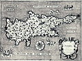 | Details | Porcacchi, Tomasso | 1572 |
| Antique map of Cyprus Cipro by Porcacchi |
|
Porcacchi, Tomasso |
|
| 1572 |
| LOC:2 |
| $375.00 | Porcacchi--Tomasso | Antique-map-of-Cyprus-Cipro-by-Porcacchi | Authentic copperplate-engraved antique map of the Mediterranean island of Cyprus (Cipro) by Tomasso Porcacchi.
<br></br>
Printed in Tomasso Porcacchi's "Isolario" or island book "L'Isol Piu Famose Del Mondo". That work contains a number of finely engraved maps of islands and the continents at a reduced scale. Porcacchi (1530-1585) was born in Tuscany to a poor family and first settled in Florence. He wrote about history, geography, and archaeology and later published the Isolario from Venice, Italy in three editions beginning in 1572. |
| 5197 | 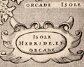 | Details | Porcacchi, Tomasso | 1572 |
| Isole Hebride et Orcade Scotland |
|
Porcacchi, Tomasso |
|
| 1572 |
| LOC:7 |
| $375.00 | Porcacchi--Tomasso | Isole-Hebride-et-Orcade-Scotland | Authentic copperplate-engraved antique map (1572) of the Hebrides and Orcades Islands off the mainland of Scotland. This map of the Orcades and Hebrides was drawn by Tomasso Porcacchi and was engraved by Girolamo Porro.
<br></br>
Printed in Tomasso Porcacchi's "Isolario" or island book "L'Isol Piu Famose Del Mondo". That work contains a number of finely engraved maps of islands and the continents at a reduced scale. Porcacchi (1530-1585) was born in Tuscany to a poor family and first settled in Florence. He wrote about history, geography, and archaeology and later published the Isolario from Venice, Italy in three editions beginning in 1572. |
| 4727 | 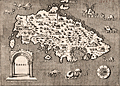 | Details | Porcacchi, Tomasso | 1572 |
| Very old antique map of Rhodes, Greece |
|
Porcacchi, Tomasso |
|
| 1572 |
| LOC:2 |
| $275.00 | Porcacchi--Tomasso | Very-old-antique-map-of-Rhodes--Greece | Authentic copperplate-engraved antique map (1572) of the Greek Dodecanese island of Rhodes (Rhodi) engraved by Girolamo Porro and drawn by Tomasso Porcacchi. Numerous fantastical sea serpents and monstrous fishes fill empty areas in the finely stippled seas. A few of the key features include smaller islands of Carchi, Limona, San Nicolo, and Tranquilla. Detail in the interior of Rhodes includes towns or villages of Villanova, Camira, Aganca, Zalfo, Sorini, Fiando, Rufarcangeli Farado, and more. The port of Rhodes or Rhodos is shown surrounded by fortified walls with several guard towers.
<br></br>
Printed in Tomasso Porcacchi's "Isolario" or island book "L'Isol Piu Famose Del Mondo". That work contains a number of finely engraved maps of islands and the continents at a reduced scale. Porcacchi (1530-1585) was born in Tuscany to a poor family and first settled in Florence. He wrote about history, geography, and archaeology and later published the Isolario from Venice, Italy in three editions beginning in 1572. |
| 916 | 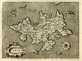 | Details | Porcacchi, Tomasso | 1572 |
| Greek Island of Zakynthos or Zante in the Ionian Sea |
|
Porcacchi, Tomasso |
|
| 1572 |
| LOC:2 |
| $175.00 | Porcacchi--Tomasso | Greek-Island-of-Zakynthos-or-Zante-in-the-Ionian-Sea | Copperplate-engraved antique map (1576), engraved by Girolamo Porro and drawn by Tomasso Porcacchi, of the Greek Ionian island of Zante or Zakynthos, the third largest of the Ionian Islands. A few of the key features Porcacchi notes on this old map of Zakynthos are: Plomati, Ambello, Zero Castelli, la Madonna, Santa Maria de Piscopo, and a large saline or salt marsh in a large bay to the north. Fantastical sea serpents fill empty areas in the finely stippled seas.
<br></br>
On a full page with text on recto and verso. Woodcut capital letter "I" at the beginning of the textual desription of Zante, in Italian, just below the map. Woodcut headpiece and a scrollwork title cartouche with simply "Zante".
<br></br>
Printed in Tomasso Porcacchi's "Isolario" or island book "L'Isol Piu Famose Del Mondo". That work contains a number of finely engraved maps of islands and the continents at a reduced scale. Porcacchi (1530-1585) was born in Tuscany to a poor family and first settled in Florence. He wrote about history, geography, and archaeology and later published the Isolario from Venice, Italy in three editions beginning in 1572. Page 98. |
| 915 | 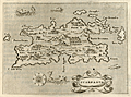 | Details | Porcacchi, Tomasso | 1576 |
| Greek Island of Karpathos or Scarpanto in the Aegean |
|
Porcacchi, Tomasso |
|
| 1576 |
| LOC:2 |
| $250.00 | Porcacchi--Tomasso | Greek-Island-of-Karpathos-or-Scarpanto-in-the-Aegean | Interesting antique map from 1576, by Tomasso Porcacchi, of the Greek Aegean island of Scarpanto or Kárpathos, about 30 miles southwest of Rhodes. Karpathos is part of the Dodecanese island group. A few of the key features Porcacchi notes on this old map are: Porto Grato, Porto Tristano, Capo Bonadrea, Castro Calamo, and Fianti. The walled village of Scarpanto is depicted on the East end of the island with three mountains directly to the west: M. St. Elya, M. Ores, and M. Anchinara.
<br></br>
On a full page with text. Wood-cut capital letter "P" at the beginning of the textual desription of Candia, in Italian, just below the map.
<br></br>
Printed in Tomasso Porcacchi's "Isolario" or island book "L'Isol Piu Famose Del Mondo". That work contains a number of finely engraved maps of islands and the continents at a reduced scale. Porcacchi (1530-1585) was born in Tuscany to a poor family and first settled in Florence. He wrote about history, geography, and archaeology and later published the Isolario from Venice, Italy in three editions beginning in 1572. Page 113. |
| 1222 | 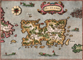 | Details | Porcacchi, Tomasso | 1576 |
| Scarce map of Puerto Rico, San Giovanni or Borichen |
|
Porcacchi, Tomasso |
|
| 1576 |
| LOC:5 |
| $350.00 | Porcacchi--Tomasso | Scarce-map-of-Puerto-Rico--San-Giovanni-or-Borichen | Fine sixteenth-century map of the Caribbean island of Puerto Rico, or Borichen as it was known by the indigenous Taino Indians. One of the earliest available maps specifically of Puerto Rico. San Juan is noted as S. Giovanni.
<br></br>
Contains the eastern coast of Cuba and a scattering of islands ( Le Vergini ) representing the British Virgin Islands. At bottom left is seen S. Croce (St. Croix). A large island off the southeast coast of Puerto Rico, "El Bacan" is probably the nearby island of Vieques. Numerous sea serpents swim in the offshore waters.
<br></br>
Printed in Tomasso Porcacchi's "Isolario" or island book "L'Isol Piu Famose Del Mondo". That work contains a number of finely engraved maps of islands and the continents at a reduced scale. Porcacchi (1530-1585) was born in Tuscany to a poor family and first settled in Florence. He wrote about history, geography, and archaeology and later published the Isolario from Venice, Italy in three editions beginning in 1572. Italian text on verso. |
| 913 | 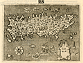 | Details | Porcacchi, Tomasso | 1576 |
| Island of Candia (Crete) in Greece |
|
Porcacchi, Tomasso |
|
| 1576 |
| LOC:2 |
| $275.00 | Porcacchi--Tomasso | Island-of-Candia-(Crete)-in-Greece | Very interesting early antique map of the Greek Mediterranean island of Candia (Crete or Kriti), the largest island in Greece. This late 16th century map, by Tomasso Porcacchi, shows some of the largest towns on the island at that time: Cania (Chania), Retimo (Rethimno), and Candia (Iraklio). Numeous small islands and islets are named offshore including Morena, Farioni, Paxmando, and Standia. In the stippled sea, empty space is filled with fanciful sea creatures, huge sea snails, crabs, and a three-masted galleon.
<br></br>
At the center of the map is a cicular design of a maze south of the town of Candia (Iraklio or Heraklion). That maze is a reference to the labyrinth of King Minos of Crete that was believed to be located at the palace at Knossos. Since classical times that site was believed to be the location where Daedalus built the labyrinth for King Minos to hold the mythical Minotaur.
<br></br>
The entrance to three caves is depicted near the southwest coast in the general vicinity of the well-known Samaria Gorge. At that spot Porcacchi has noted: "Habitation d' homini e bestiami nelle chuerne" or the dwelling of men and cattle in ?chuerne.
<br></br>
Printed in Tomasso Porcacchi's "Isolario" or island book "L'Isol Piu Famose Del Mondo". That work contains a number of finely engraved maps of islands and the continents at a reduced scale. Porcacchi (1530-1585) was born in Tuscany to a poor family and first settled in Florence. He wrote about history, geography, and archaeology and later published the Isolario from Venice, Italy in three editions beginning in 1572. Page 108. |
| 695 | 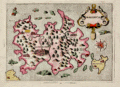 | Details | Porcacchi, Tomasso | 1686 |
| Antique map of Majorca, Balearic Islands, Spain |
|
Porcacchi, Tomasso |
|
| 1686 |
| LOC:4 |
| $325.00 | Porcacchi--Tomasso | Antique-map-of-Majorca--Balearic-Islands--Spain | Numerous fantastical sea monsters fill the empty spaces on this antique copperplate-engraved map of Majorca ( Mallorca ) , Spain the largest of the Balearic Islands. Majorca is nearly five times the size of its sister island Menorca. Majorca's history is closely tied to seafaring- the first people to colonize the island are believed to be Phoenician traders who arrived around the 8th century B.C.
<br></br>
This decorative old map was printed in 1686 in one of the last editions of Tomasso Porcacchi's "Isolario" or island book "L'Isol Piu Famose Del Mondo". This 1686 edition is differentiated from earlier versions in that: 1) it is the only edition where the maps are not set within printed text, and 2) the chart was re-engraved for this edition and the compass rose is less elaborate.
<br></br>On the compass rose Porcacchi identifies eight points that correspond to the classical eight-point naming convention for Mediterranean winds that dates back at least 2000 years. The octagonal "Tower of the Winds" of the Roman Agora in Athens, Greece contains friezes on each wall depicting the principal wind deities and was once capped with a weathervane. Porcacchi's compass rose symbols: "T", "G", "+" , "S", "O", "L", "P", "M", correspond to the Italian names for the principal Mediterranean winds: Tramontana ( North ), Greco, Levante ( with a cross denoting East ), Sirocco, Ostro ( South ), Libeccio. Ponente ( West ), and Maestro. ( Taylor, E.G.R., "The Haven Finding Art: A History of Navigation from Odysseus to Captain Cook". New York. 1957 (pp. 6-8)
<br></br>
Scrollwork title cartouche labeled simply: "Maiorica". Noted points of interest include islands of Cabrera and Dragonara, along with the Majorcan headlands of Capo Salime, P. Colombo, Monacur, Capo della Prea, Capo Formentar, Capo Baiol. Noted habitations include Maiorica ( Palma ), Cala Figera, Aliendia, Soller, Palomera, and Prementor.
<br></br>
Ample margins. Later attractive hand-coloring. |
| 687 | 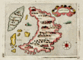 | Details | Porcacchi, Tomasso | 1686 |
| Antique map of Santorini, Greece |
|
Porcacchi, Tomasso |
|
| 1686 |
| LOC:2 |
| $300.00 | Porcacchi--Tomasso | Antique-map-of-Santorini--Greece | Old antique copperplate-engraved map of the Greek island of Santorini, Greece in the Aegean Sea. Noted points of interest include the islands of Aspronisi and Therasia, nearby Santorini, along with the Santorinan habitations of S. Salvador, Akrotiri ("Acortiri") , Scaro, and Nebrio. The colorful map was printed in 1686 in one of the last editions of Tomasso Porcacchi's "Isolario" or island book " L'Isol Piu Famose Del Mondo" which was first published in Venice ca. 1572. This 1686 edition is differentiated from earlier versions of Porcacchi's atlas in that 1) it is the only edition where the maps are not set within printed text, and 2) the chart was re-engraved for this edition and the compass rose is less elaborate.
<br></br>On the compass rose Porcacchi identifies eight points that correspond to the classical eight-point naming convention for Mediterranean winds that dates back at least 2000 years. The octagonal "Tower of the Winds" of the Roman Agora in Athens, Greece contains friezes on each wall depicting the principal wind deities and was once capped with a weathervane. Porcacchi's compass rose symbols "T", "G", "+" , "S", "O", "L", "P", "M", correspond to the Italian names for the principal Mediterranean winds: Tramontana ( North ), Greco, Levante ( with a cross denoting East ), Sirocco, Ostro ( South ), Libeccio. Ponente ( West ), and Maestro. ( Taylor, E.G.R., "The Haven Finding Art: A History of Navigation from Odysseus to Captain Cook". New York. 1957 (pp. 6-8)
<br></br>
Simple design as is common in the Isolario maps with depictions of two mythical sea monsters and a scrollwork title cartouche labeled simply: "Santorini". Seas are stippled
<br></br>
Ample margins and hand-coloring make this antique map of Santorini a fine candidate for framing. |
| 809 | 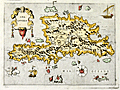 | Details | Porcacchi, Tomasso | 1686 |
| Antique map of Spagnola, or Hispaniola |
|
Porcacchi, Tomasso |
|
| 1686 |
| LOC:0 |
| | Porcacchi--Tomasso | Antique-map-of-Spagnola--or-Hispaniola | SOLD<br></br>
17th century, antique copperplate-engraved map of the Caribbean island of Hispaniola, shared by the nations of Haiti and nearby Dominican Republic. In this decorative map numerous mythical sea serpents, and sailing vessels fill empty space in the Caribbean Sea.
</br></br>
Noted points of interest include numerous capes and headlands: Cabo de los Lobos; Cabo de San Rafael; Cabo Arecifes; and the intriguing Punta del Plata e dell Argento. The village of S. Domingo is shown but no habitation is noted in the area of Port Au Prince, Haiti.
<br></br>
This small, colorful map was printed in 1686 in one of the last editions of Tomasso Porcacchi's "Isolario" or island book " L'Isol Piu Famose Del Mondo" which was first published in Venice ca. 1572. This 1686 edition is differentiated from earlier versions of Porcacchi's atlas in that 1) it is the only edition where the maps are not set within printed text, and 2) the chart was re-engraved for this edition and the compass rose is less elaborate.
<br></br>
On the compass rose Porcacchi identifies eight points that correspond to the classical eight-point naming convention for Mediterranean winds that dates back at least 2000 years. Porcacchi's compass rose symbols "T", "G", "+" , "S", "O", "L", "P", "M", correspond to the Italian names for the principal Mediterranean winds: Tramontana ( North ), Greco, Levante ( with a cross denoting East ), Sirocco, Ostro ( South ), Libeccio. Ponente ( West ), and Maestro. ( Taylor, E.G.R., "The Haven Finding Art: A History of Navigation from Odysseus to Captain Cook". New York. 1957 (pp. 6-8)
<br></br>
Ample margins and attractive hand-coloring make this antique map of Hispaniola a fine candidate for framing. |