| | Thumbnail | | Creator | Date | Title / Author / Date / Location | Price | | | Description |
| 4890 | 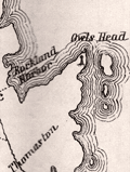 | Details | Prince, George | 1860 |
| Antique Map Georges River Adjacent Islands Explored Waymouth 1860 |
|
Prince, George |
|
| 1860 |
| LOC:0 |
| $500.00 | Prince--George | Antique-Map-Georges-River-Adjacent-Islands-Explored-Waymouth-1860 | A scarce lithographed map and booklet of Maine documenting a carto-analytic discovery by George Prince. Based on the exploration by English explorer George Waymouth (1585-1612) in 1605. Published from Bath, Maine.
<br></br>
Map by George Prince based on Rosier, locally available printed maps and one manuscript map he saw. Prince knew the area well: "Having been since my earliest childhood been acquainted with the Georges River, its entrance and all the islands." Upsetting common beliefs of the time, Rosier was able to determine that Waymouth had explored the Georges River, not the Kennebec or Penobscot rivers as many believed.
<br></br>
Rosier's narrative reminds us that our near ancestors were to say the least, "not PC". Rosier describes the capture of 3 Native Americans for transport back to England with their canoas (canoes) as a "matter of great importance."
<div class="indenttextblocksingle">
It was as much as five or sixe of us could do to get them into the light horseman [their boat]. For they were strong and so naked as our best hold was by their long haire on their heads; and <b>we would have beene very loath to do them any hurt, which of necessity we had beene constrained to have done if we had attempted them in a multitude, which we must and would, rather than to have wanted them, being a matter of great importance for the full accomplement of our voyage.</b>"
</div>
<br></br>
Booklet: With remarks by George Prince and "Rosier's Narrative of Waymouth's Voyage to the Coast of Maine in 1605" by James Rosier, chronicler of Waymouth's .
<br></br>
Scarce. Title page. Bookplate for William H. Hahn (Friendship, Maine) and MS signature (not Hahn) inside title page. 45 pages text. 1 folding map. Bath, Maine: Eastern Times Press. 1860. Reprinted from Collections of the Massachusetts Historical Society, 1843, 3d series, v. 8. |