| | Thumbnail | | Creator | Date | Title / Author / Date / Location | Price | | | Description |
| 5007 | 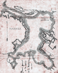 | Details | Pujals, Jose | 1891 |
| Antique manuscript map plan of the Bay of Havana, Cuba with Regla |
|
Pujals, Jose |
|
| 1891 |
| LOC:200 |
| $700.00 | Pujals--Jose | Antique-manuscript-map-plan-of-the-Bay-of-Havana--Cuba-with-Regla | MS plan and hydrographic chart of the bay of Havana, Cuba. Very early surveyor's master document on tracing cloth of Havana, Cuba with blue color from the verso, as was the practice of the era for creating shading on blueprints. This manuscript map was intended for use in generating multiple cyanotype (blueprint) copies.
<br></br>
Names several important locations including Regla, Cabana, Ensenada de Mari Melena, and Casa Blanca. The plan includes isobaths showing depth of water in Havana Bay.
<br></br>
MS notation in Spanish reads: "Corresponde a la Real Orden de consesion des dichas obras fecha de 17 de ?? Habana de 13 Febrero de 1891 J. Pujals"
<br></br>
Creator is presumed to be Jose Pujals, an engineer with the Port of Havana Cuba. In 1899 Jose Pujals was the directing engineer in charge of works at the Port of Havana. On February 1, Captain A.H. Weber of the Second United States Volunteer Engineers was appointed as directing engineer and Pujals was moved to a position as Weber's assistant.
<br></br>
Scale 1:2500. |