| | Thumbnail | | Creator | Date | Title / Author / Date / Location | Price | | | Description |
| 836 | 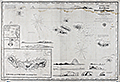 | Details | Purdy, Isaac | 1861 |
| Blueback sea chart of the Azores |
|
Purdy, Isaac |
|
| 1861 |
| LOC:0 |
| $2,700.00 | Purdy--Isaac | Blueback-sea-chart-of-the-Azores | Blueback sea chart by Isaac Purdy of the Azores Islands off the West coast of Portugal. 10 coastal elevation views include: Terceira and the Peak of Pico; Corvo and Flores. Inset port plans include: Channel between Fayal and Pico; the Road of Angra; and S. Miguel or St. Michael.
<br></br>
Published by R.H. Laurie. 53 Fleet Street, London in January 1861.
<br></br>
During the 1800's there was a trend toward publication of very large small-scale charts with large-scale insets of key passages and harbors. This made it possible for mariners to replace perhaps a half-dozen or more charts with just one. The practice was adopted as much for economics as any other reasoner. Laurie was one of a handful of British publishers who specialized in these charts which were often backed with canvas or linen cloth or heavy blue paper in order to help them withstand the frequent use and abuse aboard ship, hence the term "blueback chart". |