| | Thumbnail | | Creator | Date | Title / Author / Date / Location | Price | | | Description |
| 5314 | 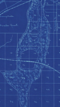 | Details | Ranson, Robert | 1906 |
| Antique map of Cracker Swamp drainage Hastings, Florida FEC |
|
Ranson, Robert |
|
| 1906 |
| LOC:87 |
| $800.00 | Ranson--Robert | Antique-map-of-Cracker-Swamp-drainage-Hastings--Florida-FEC | Cyanotype (blueprint) cadastral plat map of the vicinity around Hastings, Florida, the "Potato Capital of Florida", featuring a proposed drainage canal from the St. Johns River to Hawhead at the northernmost point of what is today referred to as "Cracker Swamp" . This early plat of the area in Volusia County, is from an auction lot of maps related to Wetumpka Fruit Company. The map was published in 1906 just 16 years after Hastings was founded by Thomas Hastings [1] at the urging of his cousin <b>Henry Morrison Flagler</b>. Hastings, northeast of East Palatka, Florida, in St. Johns County, had a population of about 1,200 in 1910.
<br></br>
With a graphed depth profile (at left) of the proposed canal running from the vicinity of May Road (Mays Cove Road) on the St. Johns River to Hawhead. Depth measurements are provided every 400 feet.
<br></br>
Shows the tracks of the Florida East Coast Railroad curving through Hastings, a portion of the <b>Huertas Grant</b> [2], East Palatka, and across Deep Creek. Other noted features include: Leonard Tract, White Towers, Buncombe Island (inside the "Cracker Swamp"), orange mills, Florida Vegetable Company Boulevard; and two short branches off Deep Creek- Wilkinson Branch and Cracker Branch.
<br></br>
[1] In 1889 Henry Flagler convinced his cousin Thomas H. Hastings to develop a farm nearby Flagler's railroad in order to supply vegetables to Flagler's St. Augustine resort hotels.<br>
[2] Spanish Governor Sebastien Kindelan granted St. Augustine, Florida resident Antonio Huertas 10,000 acres west of St. Augustine in 1813. |