| | Thumbnail | | Creator | Date | Title / Author / Date / Location | Price | | | Description |
| 763 | 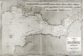 | Details | Robiquet, Aime | 1850 |
| Antique Chart of the Bristol Channel in England |
|
Robiquet, Aime |
|
| 1850 |
| LOC:0 |
| $350.00 | Robiquet--Aime | Antique-Chart-of-the-Bristol-Channel-in-England | Antique French hydrographic chart of southwest Wales and England surrounding the Bristol Channel. Coverage extends from Stackpole clockwise past Swansea, Barry, Cardiff, to Bristol, and moving south-westward to Portishead, Burnham, Bridgewater, Watchet, Minehead, Ilfracomb, Barnstaple, terminating at Kilkhampton. This is a privately published chart by Aime Robiquet, a French Hydrographer, but based on work by Denham and Robinson for an earlier British Admiralty chart. Inset at upper right contains numerous profile coastal views. Interesting small oval blind stamp by Robiquet at bottom right margin.
<br></br>
Numerous soundings, aids to navigation, compass course notations, current flows, and navigational hazards are noted.
<br></br>
This large nautical chart was published by Robiquet in the 'Atlas Hydrographique, one of 75 charts published in that atlas from in 1856. Rue Pavée Saint-André des Artes No. 2, Paris, France. Printed by Mangean, rue St Jacques. Price when issued was four francs. Number 9. |
| 797 | 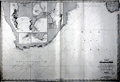 | Details | Robiquet, Aime | 1854 |
| Antique chart of Table Bay, False Bay and Cape Town, South Africa |
|
Robiquet, Aime |
|
| 1854 |
| LOC:0 |
| $1,250.00 | Robiquet--Aime | Antique-chart-of-Table-Bay--False-Bay-and-Cape-Town--South-Africa | Very special antique nautical chart of the southern-most portion of the African continent and southern Madagascar below 23 degrees south latitude. Carries Robiquet's blind stamp at bottom and also a blue over-stamp of the seller: Antoine Roux Fils of Marseilles, France. The Roux family had a long history as chart-makers, chart-sellers and nautical artists in Marseilles extending well over 100 years.
<br></br>
This large, French, steel-plate navigational chart of South Africa includes Angra Pequena, Saint Helena Bay, Cape Town ("Captown"), the Cape of Good Hope ("Cap du Bonne Esperance") , Cape Infanta, Cape St. Francis, Cape St. Lucia, and Cape Correntes, Mozambique and a large portion of the southern Indian Ocean.
<br></br>
Includes inset plans of False Bay and Table Bay; Port Natal; Delagoa Bay; Cape Agulhas ("Cap de Aguilles"); and Dyer Island and Point Danger.
<br></br>
This large nautical chart was published privately by hydrographer Aime Robiquet in the 'Atlas Hydrographique', one of 75 charts published in that atlas in 1856. Rue Pavée Saint-André des Artes No. 2, Paris, France. Printed by Louis Antoine, Rue de Noyers, 70. Price when issued was four francs. Number 44.
<br></br> |
| 1090 | 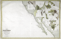 | Details | Robiquet, Aime | 1856 |
| Rare Antique French Chart of the California Coast and Baja Peninsula |
|
Robiquet, Aime |
|
| 1856 |
| LOC:68 |
| $3,000.00 | Robiquet--Aime | Rare-Antique-French-Chart-of-the-California-Coast-and-Baja-Peninsula | Very rare engraved chart of the California coast from Shelter Cove south to Mazatlan, Mexico: "Carte des Côtes de Californie de Mazatlan à San Francisco d'Après les derniers Travaux Amércains Par Robiquet, Hydrographe Rue Pavée Saint Andre No.2. Paris 1856". This large chart is particularly interesting for its collection of numerous inset plans of North American West Coast ports and bays during the late California Gold Rush.
<br></br>
Coverage includes the <b>Baja Peninsula</b> or "Vieille Californie" with Cabo San Lucas ("Cap St. Lucas") at the end. Contains inset plans of the bays and ports at Guaymas, Ballena, St. Bartholomé, Pulpito, San Quentin, San Diego, San Pedro, Monterey, San Francisco, and Bodega Bay.
<br></br>
Scarce and detailed map of California's coastline, with much detail for navigation and a few inland landmarks. Printed in Paris by French hydrographer and publisher Louis Antoine Robiquet. Presumably from Robiquet's "Atlas Hydrographique" of 1856, but this printing with separate price (4 francs) and publisher's blind stamp in bottom right margin. Only one institutional copy is recorded in WorldCat.
<br></br>
Inset plans include: (1): Baie Bodega Levé en 1839 par Ed. Belcher. (2): Plan de la Baie de Monterey Levé en 1837 par Mr. De Tessan, Ingr. Geographe. (3): Entrée du Port de San Francisco par Cadwalader Ringgold. (4): San Pedro par James Alden 1852. (5): Entrée de San Diego par R.D. Cutts et G. Davidson. (6): Port San Quentin Levé in 1839 par Ed. Belcher. (7): Port St. Bartholomé Levé par le Cape. H. Kellet en 1847. (8): Mouillage Pulpito par le Cape. H. Kellet. (9): Port Balleno par le Cape. H. Kellet. (10): Guaymas Levé par Mr. Fisquet en 1840.
<br></br>
No. 61. Paris - Imp. Louis |
| 803 | 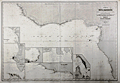 | Details | Robiquet, Aime | 1858 |
| Coast of West Africa |
|
Robiquet, Aime |
|
| 1858 |
| LOC:0 |
| $400.00 | Robiquet--Aime | Coast-of-West-Africa | Large antique steel plate engraved nautical chart of the West coast of Africa from Cape Verga south and west to Cape Ledo. Includes the small offshore islands of Fernando Po, São Tomé , and Principe or "Isle du Prince". Streches of coastline are named after the primary resource exported from the area and include the Gold Coast or "Côte d'Or"; the Ivory Coast or "Côte d'Ivoire"; and the "Côte de Calebar".
<br></br>
At bottom right seven detailed inset harbor plans include: Edina et Grand Bassa, Monrovia et Cape Mesurado, Plan de la Entrée de Sierra Leone, Baie de l'Ouest, Entrée de Vieux Calebar, Cap des Palmes, and Plan du Bassin Exterieur du Gabon. Contains numerous soundings and arrows indicating the primary direction of the current. Relative current strength is indicated by the number of feathers drawn on each arrow.
<br></br>
This antique chart was separately published by French hydrographer and publisher Aime Robiquet. Robiquet is best known as publisher of the "Atlas Hydrographique", a nautical atlas comprised of 75 large charts published from Paris between 1856 and 1861. This chart carries the imprint of Robiquet's oval-shaped blind stamp at the bottom right margin. Number 36. |
| 799 |  | Details | Robiquet, Aime | 1863 |
| Antique nautical chart of Sri Lanka or Ceylon |
|
Robiquet, Aime |
|
| 1863 |
| LOC:0 |
| $0.00 | Robiquet--Aime | Antique-nautical-chart-of-Sri-Lanka-or-Ceylon | SOLD
<br></br>
Antique French sea chart of the island of Sri Lanka, or as it was known before 1972- Ceylon. A large separately published steel plate navigational chart by French hydrographer and publisher Aime Robiquet. Includes the Southeast coast of India from Puducherry ("Pondicherry") extending south-westward, past Tuticorin ("Tutacorin") to Tiruchendur ("Trichindore"). Large French nautical chart encompasses the full extent of Sri Lanka and its offshore waters with numerous soundings, hazards, and coastal geographic features noted and named.
<br></br>
Includes two large inset harbor plans: of Colombo (1838), and Pointe de Galle (1858). Single horizontal fold as issued. Sparse interior detail is as common for many sea charts. |
| 1283 | 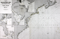 | Details | Robiquet, Aime | 1871 |
| Carte de la Cote des Etats-Unis Comprise Entre la Nouvelle-Ecosse et la Floride |
|
Robiquet, Aime |
|
| 1871 |
| LOC:0 |
| $1,350.00 | Robiquet--Aime | Carte-de-la-Cote-des-Etats-Unis-Comprise-Entre-la-Nouvelle-Ecosse-et-la-Floride | Fine chart of the east coast of North America. A scarce privately-published chart by Robiquet from Paris in 1871. Chart coverage includes Prince Edward Island and the Bay of Fundy, coastal Nova Scotia, Maine, New Hampshire, Massachusetts, Connecticut, Rhode Island, New Jersey, New York, Delaware, Virginia, North Carolina, Bermuda, South Carolina, Georgia and Florida. Numerous depth soundings and lighthouses higlighted in yellow.
<br></br>
At the bottom a paste-on stamp from the seller, the very cool "Librairie des Navigateurs" in Bordeaux, France. Four detailed inset charts include:
<div class="indenttextblock">
<ul style="list-style-type: circle;">
<li>Baie de New York</li>
<li>Charleston, S.C.</li>
<li>Carte de la Baie Delaware</li>
<li>The Florida Peninsula or "Complement de la Partie Meridionale des Etats-Unis"</li>
</ul>
</div>
This large nautical chart was published privately by hydrographer Aime Robiquet in 1871. Rue Pavée Saint-André des Artes No. 2, Paris, France. Printed by Louis Antoine. Number 44 |