| | Thumbnail | | Creator | Date | Title / Author / Date / Location | Price | | | Description |
| 5312 | 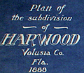 | Details | Rogers, P. D. | 1888 |
| Antique cyanotype cadastral map Harwood Volusia County Florida Old Kings Road |
|
Rogers, P. D. |
|
| 1888 |
| LOC:53 |
| $0.00 | Rogers--P--D- | Antique-cyanotype-cadastral-map-Harwood-Volusia-County-Florida-Old-Kings-Road | SOLD<br><br>Rare early cyanotype (blueprint) cadastral plat map of the subdivision of <b>Harwood</b> in Volusia County, Florida (near Bulow Creek State Park), bounded to the west by the <b>Old King's Road</b>. Only known cadastral map that locates the failed "Harwood" settlement. The plat is the oldest of two known reference sources for the location of the Old King's Road in Volusia County. A valuable historic reference, the map shows land use: marsh, hammocks, islands, and groves.
<br></br>
The Harwood settlement was planned by orange grower Norman B. Harwood who in 1880 purchased 4,000 acres in Volusia County, including the Ormond Plantation "Damietta" [1]. The Harwood settlement was a failure. Deeply in debt, Norman Harwood died in May, 1885.</b>
<br></br>
During the second Spanish occupation of Florida, Spain granted large tracts of land in the Tomoka basin to settlers as an inducement to move to the region. These settlers included the Ormonds, Bulows [2], McHardys [3], and Dummitts [4].
<br></br>
Surveyed in 1888 by Civil Engineer P. D. Rogers of Daytona, Florida. North oriented at right. Manuscript notations.
<br></br>
The plat shows the tomb of James Ormond II who died September 30, 1829 (now Ormond Tomb State Park). Includes an inset context map of the Florida coast from Jacksonville to Mosquito Inlet with the St. Johns River. The context map shows the settlement of Harwood prominently near the coast just north of Ormond, Fla.
<br></br>
<b>NOTES:</b><br>
[1] The landmark Fairchild Oak and the Ormond Tomb (see plat) are both located on land shown on this plat. The Spanish granted sea captain James Ormond 2,000 acres in 1807.<br>
[2] Bulow Creek bounds the property to the northeast alongside a now lost "Atlantic Avenue".<br>
[3] Robert Mc Hardy, a surveyor, received a Spanish grant of 1,100 acres in 1808. <br>
[4] Dummitt Plantation, directly south of this plat, was the site of the first steam-powered sugar mill in the area. |