| | Thumbnail | | Creator | Date | Title / Author / Date / Location | Price | | | Description |
| 404 | 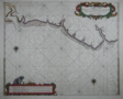 | Details | Roggeveen, Arent | 1675 |
| Paskaert vande Cust van Westindien |
|
Roggeveen, Arent |
|
| 1675 |
| LOC:51 |
| $4,500.00 | Roggeveen--Arent | Paskaert-vande-Cust-van-Westindien | This rare antique chart is the earliest available detailed sea-chart of this portion of the Guyana coastline. On this fine Dutch foundational sea chart from ca. 1675 coverage stretches from Rio Soronama (Suriname River) and Paramaribo, Suriname in the east to the west past Rio Demerary (Demerara River) and Georgetown, Guyana. Fort Paramaribo is the sole noted habitation, reflecting both the early date of the chart and the fort's importance for trading. The course of the Demerara River is shown with soundings to past St. Iohannes Island (St. John's Island), about 15 miles from the river's mouth.<br></BR>
This old nautical chart appears in the First Part of the Burning Fen or "Het Brandende Veen" created by Arent Roggeveen and published by <a rel="nofollow" href="/creator/Goos--Pieter/" >Pieter Goos</a> . Dr. C. Koeman described the significance of this work as of the same order as Waghenaer's Der Spieghel der Zeevaerdt: <br>
<dir class="indenttextblock">"The First Part of the Burning Fen rates as one of the most important printed Pilot Books. The First Part of the Burning Fen, published by Pieter Goos in 1675, is the first pilot book containing charts of the Central American coasts and islands that ever appeared in print."</dir> </BR>
Unlike Waghenaer, Arent Roggeveen was not a sea captain but rather a trained land-surveyor who taught navigation in the town of Middelburg to pilots of the Dutch West India Company which was headquartered there. Roggeveen likely had access to manuscript charts from Guyana and possibly to early Spanish portolan charts through his connections with the West India Company.<BR> </BR> |