| | Thumbnail | | Creator | Date | Title / Author / Date / Location | Price | | | Description |
| 6476 | 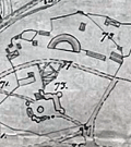 | Details | Rosen, Ludwig | 1890 |
| Engineers manuscript contour drainage plan of the Gärdet in Stockholm Sweden |
|
Rosen, Ludwig |
|
| 1890 |
| LOC:1402 |
| $900.00 | Rosen--Ludwig | Engineers-manuscript-contour-drainage-plan-of-the-Gärdet-in-Stockholm-Sweden | Early and rare engineer's pen and ink manuscript contour drainage plan of Stockholm's Ladugårdsgärdet [1] by States Engineer Ludwig Rosen in 1890. A hand-drawn and hand colored detailed plan on supple surveyors tracing cloth covering land that was at the time largely undeveloped. Today the outer portions of the Gärdet are well developed leaving a central open space that is part of Stockholm’s National City Park.
<br><br>
An important manuscript engineering plan related to urban growth, development, and the environmental preservation of Stockholm, Sweden.
<br><br>
<div id="0" align="center">
<a title="Täckdikningsplan for Ladugårdsgärde vid Stockholm"></a>
<img id="3" src="/ZoomifyImages/SC_6476/SCV_6476_Title.jpg" alt="Täckdikningsplan for Ladugårdsgärde vid Stockholm" width="300"/> <br><small>Title to Rosen's plan of the Ladugårdsgärde (1890)</small>
</div><br>
Plan shows land contour and numerous profile cross-section inset drawings. From a translation of the title "Täckdikningsplan" we can derive that the purpose of the plan was for the development of "cover ditches" or sub-surface drainage systems. North oriented to upper left. Detailed explanatory legend fills the left side of the plan.
<br><br>
[1] Ladugårdsgärdet or Gärdet is a suburb in Stockholm County east and northeast of Östermalm with a current population of roughly 21,500 residents. Until the mid 1800’s, the eastern areas of Stockholm were known as Ladugårdslandet, or “The Barn Land.” Throughout the 1900’s, large areas of Gärdet were developed. |