| | Thumbnail | | Creator | Date | Title / Author / Date / Location | Price | | | Description |
| 5322 | 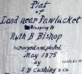 | Details | S. B. Cushing and Company | 1875 |
| Antique manuscript map Seekonk or Pawtucket River Rhode Island |
|
S. B. Cushing and Company |
|
| 1875 |
| LOC:300 |
| $350.00 | S--B--Cushing-and-Company | Antique-manuscript-map-Seekonk-or-Pawtucket-River-Rhode-Island | Scarce historic manuscript pen and ink surveyor's plat map of several tracts of land owned by Phanuel E. Bishop at what is now called "Bishop Point" in Pawtucket, Rhode Island. North is oriented to the bottom. The land, about one mile north of the Phillipsdale Historic District, is bordered to the south and west by the Seekonk (Pawtucket) River, by Bishop Street to the north, and bordered by Charlton Street to the east. The plat, comprised of tracts totaling about 20 acres, shows the line of the high water mark at the boundary of the Pawtucket River.
<br></br>
<img src="https://digitalcollections.uhv.edu/digital/api/singleitem/image/p16791coll2/3342/default.jpg" alt="Phanuel E. Bishop in uniform ca. 1862" width="120" align="left" style="margin: 0px 20px">
Captain Phanuel Euclid Bishop (1844 - 1890) served during the War of the Rebellion in Company H. Ninth Rhode Island Infantry from May 1862 to September 1862. Bishop entered the 1867 class at Brown University where he studied for one year. Bishop then served in Company B, First Battalion Fourteenth Regiment of the Rhode Island Heavy Artillery during 1864 and left the army in October 1865 with the rank of Captain.
<br></br>
The map is a manuscript trace on surveyor's tracing cloth paper by S. B. Cushing and Company Rhode Island. A true copy dated October 9, 1878 signed by Lewis Pearce, Town Clerk.
<br></br>
See online: Chenery, William H. The Fourteenth Regiment Rhode Island Heavy Artillery (Colored,) in the war to preserve the Union 1861 - 1865. Providence. Snow & Farnham. 1898. p. 301. |