| | Thumbnail | | Creator | Date | Title / Author / Date / Location | Price | | | Description |
| 1356 | 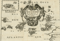 | Details | Sanson, Nicolas | 1680 |
| Fine antique map of the Canary Islands and Madeira ca. 1680 |
|
Sanson, Nicolas |
|
| 1680 |
| LOC:7 |
| $325.00 | Sanson--Nicolas | Fine-antique-map-of-the-Canary-Islands-and-Madeira-ca--1680 | Very attractive early map of the <b>Canary Islands by Nicolas Sanson</b>. Inset map of Madeira ("Isle Madere"). This fine copper-plate engraved map is dominated by a large scroll-work title cartouche, which is decorated with an elaborate garland of fruit. Nice details of towns and geography for each island.
<br></br>
Nicolas Sanson (1600 – 1667) was a French cartographer, termed by some as the "father of French cartography". Nicholas Sanson was born in the town of Abbeville in Picardy. He became become Royal Geographer to Louis XIII in 1630 and maintained the position upon the ascension of the "Sun King" Louis XIV in 1643. Sanson later served as tutor to the ambitious young monarch. From 1648 Nicolas Sanson produced a series of four quarto atlases on the continents. That atlas of Africa was first published in 1656 and included this map.
<br></br>
The Canary Islands are a Spanish archipelago that lies off the coast of northwestern Africa. Sanson's names for the main Canary Islands and their modern equivalents are: "Isle de Palme" (La Palma), "Isle de Gomer" (La Gomera), "Isle Teneriffe" (Tenerife), "Isle Canarie" or "Grande Canarie" (Gran Canaria), "Isle de Forte" (Fuerteventura), and "Isle de Lancelotte" (Lazarote). |