| | Thumbnail | | Creator | Date | Title / Author / Date / Location | Price | | | Description |
| 686 | 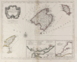 | Details | Santini, Paolo | 1776 |
| Balearic islands of Minorca, Majorca, Ibiza, Spain. |
|
Santini, Paolo |
|
| 1776 |
| LOC:0 |
| $0.00 | Santini--Paolo | Balearic-islands-of-Minorca--Majorca--Ibiza--Spain- | SOLD<BR> </BR>
Attractive old antique map of the Balearic Islands of Ibiza ( Catalan= Eivissa ), Majorca ( Mallorca ), and Minorca ( Menorca ). Coverage of dozens of villages and geographic features including: Isles Fromentieres, Ibiza village, Chateau St. Hilaire, Isle Cabraire, Baie d'Artas, Cap de Pedra, Isle Dragoniere, Cap Fromentelli, Port Colomb, Cap Mahon, Cap Bajoli, and Cap de Citadella. Sparse soundings and anchorages are identified.
<br></br>
Includes two inset maps: a) Detailed inset map (8" x 5") of the Port of Mahon, Majorca with Fort St. Philippe, Fort St. Charles, and the village of Mahon. 17 important locations are listed in a legend above the inset and tied to map locations though alphabetic references. b) Inset of the western Mediterranean showing the relative location of the three Balearic islands to other geographic features and to population centers. Contains a central compass rose with radiating rhumb lines.
<br></br>
By Paolo Santini after the work of Jacques Bellin of the French Depot de la Marine. From Santini's "Atlas Universel". Published from Venice, Italy ca. 1776. |
| 1134 | 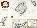 | Details | Santini, Paolo | 1776 |
| Antique Chart of the Balearic Islands of Minorca, Majorca, Ibiza, Formentera |
|
Santini, Paolo |
|
| 1776 |
| LOC:0 |
| $0.00 | Santini--Paolo | Antique-Chart-of-the-Balearic-Islands-of-Minorca--Majorca--Ibiza--Formentera | SOLD<br></br>Very attractive antique chart by Santini of Spain's Balearic Islands: Ibiza ( Yvice ), Majorca ( Maillorque ), Minorca ( Minorque ) and Formentera and other smaller islands in the archipelago. The archipelago forms an autonomous community and a province of Spain, with <b>Palma de Mallorca</b> as the capital.
<br></br>
Coverage on this scarce old map includes dozens of villages and geographic features including: Ibiza village, Chateau St. Hilaire, Isle Cabraire, Baie d'Artas, Cap de Pedra, Isle Dragoniere, Cap Fromentelli, Port Colomb, Cap Mahon, Cap Bajoli, and Cap de Citadella. Sparse soundings and anchorages are identified. Contains a central compass rose with radiating rhumb lines.
<br></br>
Includes two inset maps:
<div class="indenttextblock">
<ul style="list-style-type: circle;">
<li>Detailed inset map (8" x 5") "Plan du port et de la ville de Mahon". The inset includes the Port of Mahon, Majorca with Fort St. Philippe, Fort St. Charles, and the village of Mahon. 17 important locations are listed in a legend above the inset and tied to map locations though alphabetic references.
</li>
<li>
Inset of the western Mediterranean showing the relative location of the three Balearic islands to other geographic features and to population centers.
</li>
</ul>
</div>
By Paolo Santini after the cartography of J.N. Bellin of the French Depot de la Marine ca. 1740. From Santini's " Atlas Universal Dresse-Cartes Moderne". Published from Venice, Italy in 1776. |