| | Thumbnail | | Creator | Date | Title / Author / Date / Location | Price | | | Description |
| 780 | 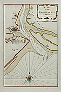 | Details | Sayer, Robert | 1789 |
| Antique nautical chart of the Harbor of Rye in Sussex, England |
|
Sayer, Robert |
|
| 1789 |
| LOC:89 |
| $425.00 | Sayer--Robert | Antique-nautical-chart-of-the-Harbor-of-Rye-in-Sussex--England | Beautiful antique nautical chart/plan depicts the coast of Kent and nearby towns of Rye and Playden ( Playdon ), England along with the Rye Camber and part of the Romney Marshes. This scarce harbor chart by Robert Sayer was published in 1789 and shows the navigational channel to Rye harbor marked by beacons as well as numerous soundings at high and low water. Noted features include Winchelsea Castle, Stoney Beach, the East Bar, Wenneway River, Camber Point, Guildford Gut, Black Shore, and a single windmill between Rye and Playden.
<br></br>
Sayer borrowed heavily from a chart published earlier by Greenville Collins. Two obvious differences are that the Romney Marsh in Collin's chart is here labeled 'Walland Marsh' and in this chart the town called Playdon is called 'Socket' on Collins'. Sayer's chart carries this additional note not found on Collin's chart: "A flag by day & a light by night are hoisted on the west pier-head of the new harbour of Rye, whenever there are nine feet water at the mouth of the harbour."
<br></br>
With a colorful compass rose. Published by Robert Sayer, Map and Chart-seller. 53 Fleet Street, London in "The Channel Pilot". Number 8 stamped in upper right corner. |
| 1383 | 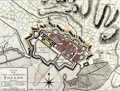 | Details | Sayer, Robert | 1793 |
| Antique map of Provence, France related to the Siege of Toulon |
|
Sayer, Robert |
|
| 1793 |
| LOC:0 |
| $300.00 | Sayer--Robert | Antique-map-of-Provence--France-related-to-the-Siege-of-Toulon | Three fine antique maps on one sheet related to the French Revolutionary War, and in particular the Siege of Toulon (Aug. 1793 - Dec. 1793). It was at the important naval base of Toulon where young Napoleon Bonaparte won his first military victory. Coverage of coastal Provence, France includes the Côte d'Azure with Monaco, Nice, Antibes, and St. Tropez. Trending to the west it shows the Bay de Hyeres, Marseilles, Avignon, Agde, Narbonne, Perpignan, and Port Vendres.
<BR></BR>
The top map shows the coastline of Southern France from the border with Italy to the border with Spain. Fortified towns and post roads are delineated. Bottom left inset map of "The Roads of Toulon with the Adjacent Country" showing the position of Toulon at much greater scale, and extensive soundings, anchorages, and landmarks in the Little Road and Great Road of Toulon. (Note: A road is a sheltered location where vessels may lie at anchor). Bottom right inset is "Plan of the City and Harbour of Toulon", a detailed plan showing the city with references to the various bastions.
<BR></BR>
Published October 10, 1793 by Robert Sayer & co. Fleet Street, London. |