| | Thumbnail | | Creator | Date | Title / Author / Date / Location | Price | | | Description |
| 2576 | 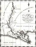 | Details | Schultz, Christian | 1810 |
| Early Original Map of the Mississippi River from Ohio R. to Gulf of Mexico |
|
Schultz, Christian |
|
| 1810 |
| LOC:10 |
| $0.00 | Schultz--Christian | Early-Original-Map-of-the-Mississippi-River-from-Ohio-R--to-Gulf-of-Mexico | SOLD
<br></br>
Finely executed original antique map of the <b>Mississippi River</b> from <b>Fort Jefferson, Kentucky</b>, near the junction with the Ohio River, to the Gulf of Mexico. Fort Jefferson was established in 1780 by George Rogers Clark at the express instruction of the then Governor of Virginia, Thomas Jefferson. The fort was abandoned in June 1781.
<br></br>
The area bounded by Bayou Manchac, Lake Ponchartrain and the Mississippi River is labeled "Island of New Orleans". In 1803 Alexander Hamilton wrote <div class="indenttextblock">"The Island of New-Orleans is in length about 150 miles; its breadth varies from 10 to 30 miles. Most of it is a marshy swamp, periodically inundated by the river. The town of New-Orleans, situated about 105 miles from the mouth of the river, contains near 1300 houses, and about 8000 inhabitants, chiefly Spanish and French. It is defended from the overflowings of the river, by an embankment, or leveé, which extends near 50 miles."(Purchase of Louisiana, [5 July 1803],” Founders Online, National Archives, last modified June 13, 2018, http://founders.archives.gov/documents/Hamilton/01-26-02-0001-0101.) </div>
<br></br>
This fine antique copper-plate engraved map is is one of the earliest maps of the Mississippi River published in America. Drawn by Christian Schultz. Two maps on one sheet.
<br></br>
Published in 1810 for Christian Schultz's "Travels on an Inland Voyage Through the States of New York, Pennsylvania, Virginia, Ohio, Kentucky and Tennessee, and through the territories of Indiana, Louisiana, Mississippi, and New-Orleans; performed in the years 1807 and 1808…"
<br></br>
Schultz's work is one of the earliest works to give a detailed account of travel and the actual risks and dangers encountered in the western country. Schultz's book is a compilation of his letters, and was published in direct response to the negative reports in an earlier travel guide written by Englishman Thomas Ashe in 1806. |
| 3654 |  | Details | Schultz, Christian | 1810 |
| Early Original Map of the Hudson and Mohawk Rivers |
|
Schultz, Christian |
|
| 1810 |
| LOC:0 |
| $0.00 | Schultz--Christian | Early-Original-Map-of-the-Hudson-and-Mohawk-Rivers | SOLD<br></br>
Schultz's very early map of the with the Hudson, Mohawk, Allegheny, and Ohio Rivers. Shows a water-based transportation route from New York City to Pittsburg via the system of rivers and lakes with only a single portage required at the southern portion of Lake Erie.
<br></br>
Includes portions of Lake Ontario and Lake Erie. Follows the rivers' course from New York City and the Hudson River to Lake Ontario, via the Hudson River and Mohawk River; then follows the Ohio River, via Fort Erie and the Allegheny river.
<br></br>
Published in 1810 for Christian Schultz's "Travels on an Inland Voyage Through the States of New York, Pennsylvania, Virginia, Ohio, Kentucky and Tennessee, and through the territories of Indiana, Louisiana, Mississippi, and New-Orleans; performed in the years 1807 and 1808…"
<br></br>
Schultz's work is one of the earliest works to give a detailed account of travel and the actual risks and dangers encountered in the west. Schultz's book is a compilation of his letters. The book was published in direct response to the negative reports in an earlier travel guide written by Englishman Thomas Ashe in 1806. |
| 2571 |  | Details | Schultz, Christian | 1810 |
| Early Original Map of the Ohio River Between Pittsburgh and St. Louis |
|
Schultz, Christian |
|
| 1810 |
| LOC:0 |
| $0.00 | Schultz--Christian | Early-Original-Map-of-the-Ohio-River-Between-Pittsburgh-and-St--Louis | SOLD<br></br>Finely executed original antique map of the Ohio River between Pittsburgh, Pennsylvania and St. Louis, Missouri. This fine antique copper-plate engraved map is one of the earliest maps of the Ohio River published in America. Drawn by Christian Schultz.
<br></br>
Published in 1810 for Christian Schultz's "Travels on an Inland Voyage Through the States of New York, Pennsylvania, Virginia, Ohio, Kentucky and Tennessee, and through the territories of Indiana, Louisiana, Mississippi, and New-Orleans; performed in the years 1807 and 1808…"
<br></br>
Schultz's work is one of the earliest works to give a detailed account of travel and the actual risks and dangers encountered in the western country. Schultz crossed upstate New York and western Pennsylvania, then went down the Ohio and Mississippi rivers to New Orleans, traveling inland along the way. Schultz's book is a compilation of his letters, and was published in direct response to an earlier travel guide written by Englishman Thomas Ashe in 1806. Ashe had traveled on both of these rivers and wrote mostly negative reports, arousing much bitterness among Americans toward British visitors. |