| | Thumbnail | | Creator | Date | Title / Author / Date / Location | Price | | | Description |
| 4881 | 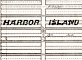 | Details | Seattle Municipal Plans Commission | 1911 |
| Seattle Harbor Island Waterfront District Antique Plan |
|
Seattle Municipal Plans Commission |
|
| 1911 |
| LOC:88 |
| $60.00 | Seattle-Municipal-Plans-Commission | Seattle-Harbor-Island-Waterfront-District-Antique-Plan | Antique plan of the Harbor Island Waterfront District in Seattle, Washington. Coverage extends from the proposed Outer Harbor Line to west Spokane Street and then south of Whatcom Avenue. Harbor Island is an artificial island in the mouth of the Duwamish River. When Harbor Island was completed in 1909 it was the largest (350 acres) artificial island in the world.
<br></br>
Includes two 750 foot wide slips and numerous tracks for the railways. At least 4 slips for ferry boats are shown just inside the inner harbor line.
<br></br>
The map fronts on Elliott Bay and includes features of the Duwamish East Waterway, Duwamish West Waterway, Harbor island, and the northern portion of the West Industrial District.
<br></br>
By Virgil G. Bogue, engineer. Date within to September, 1911. Map number 6. |