| | Thumbnail | | Creator | Date | Title / Author / Date / Location | Price | | | Description |
| 6472 | 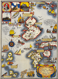 | Details | Shurtleff, Elizabeth | 1927 |
| Rare pictorial map of the Isle of Shoals |
|
Shurtleff, Elizabeth |
|
| 1927 |
| LOC:53 |
| $2,100.00 | Shurtleff--Elizabeth | Rare-pictorial-map-of-the-Isle-of-Shoals | Very rare original full-color lithographed pictorial map of the Isle of Shoals from 1927 designed and drawn by Elizabeth Shurtleff. Copyright by Jessie E. Donahue (1927). Beautiful, saturated colors. With verse by Celia Thaxter and Frederick T McGill.
<br><br>
Only two copies of Elizabeth Shurtleff's 1927 map of the Isle of Shoals were found in WorldCat. No record of a sale of the map was found online. A later much-revised edition of the Shurtleff's map was copyrighted and published in 1960 by Edward Rowe Snow.
<br><br>
Captain John Smith discovered the Isle of Shoals in 1664 lying about seven miles offshore on the border of what are today the states of New Hampshire and Maine. |