| | Thumbnail | | Creator | Date | Title / Author / Date / Location | Price | | | Description |
| 5016 | 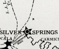 | Details | Silver Springs Transportation Company | 1924 |
| Map of Silver Springs Daylight Route Cruise Ocklawaha River |
|
Silver Springs Transportation Company |
|
| 1924 |
| LOC:11 |
| $295.00 | Silver-Springs-Transportation-Company | Map-of-Silver-Springs-Daylight-Route-Cruise-Ocklawaha-River | Florida 1920's land-boom era map of Silver Springs Daylight Route cruise over the Silver River, Ocklawaha River, and St. John's River Florida, a distance of 135 miles. Map is one page in a folded brochure "Daylight Route Ocklawaha River" produced by the Silver Springs Transportation Company for the 1923-24 season. For more than a century tourism and transportation have both greatly contributed to Florida's growth. The map, supported by the rest of the brochure, details the route, landings, and sights for one of three boats operated by the Silver Springs Transportation Company the "City of Ocala", "Silver Springs", and "Wekiwa".
<br></br>
During the season two trips were offered daily, six days a week with one boat traveling from Silver Springs to Palatka and the other from Palatka to Silver Springs. Map identifies important points along the trip including Gore's Landing, Hell's Half Acre, Forty Feet Cliff, Fort Brooks, McBride's landing and many more. |