| | Thumbnail | | Creator | Date | Title / Author / Date / Location | Price | | | Description |
| 4872 | 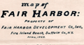 | Details | Smith, Eugene R. | 1928 |
| Cadastral Map Fair Harbor Development Fire Island New York |
|
Smith, Eugene R. |
|
| 1928 |
| LOC:13 |
| $200.00 | Smith--Eugene-R- | Cadastral-Map-Fair-Harbor-Development-Fire-Island-New-York | Seldom seen cadastral map of one section (2) of a new development platted in 1928 for sale on Fire Island in New York. Map of Fair Harbor Property of Fair Harbor Development Co., Inc. Fire Island Beach, Suffolk Co. N.Y. Section 2.
<br></br>
Coverage includes Fifth Avenue, Holly Walk, Oak Walk, and Pine Walk streets and their alleys between the Atlantic Ocean and Great South Bay on Fire Island. The section lies between the Fair Harbor Ferry Dock and the Dunewood Ferry Dock. Rare.
<br></br> |