| | Thumbnail | | Creator | Date | Title / Author / Date / Location | Price | | | Description |
| 5148 | 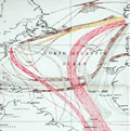 | Details | Somerville, Boyle T. | 1950 |
| Chart of routes used by ocean-going sailing ships. |
|
Somerville, Boyle T. |
|
| 1950 |
| LOC:0 |
| $0.00 | Somerville--Boyle-T- | Chart-of-routes-used-by-ocean-going-sailing-ships- | SOLD<br><br>
Large, colorful thematic nautical chart showing the most common routes utilized by sailing ships and the season of year each route was commonly used. The chart was compiled by Rear Admiral Boyle T. Somerville to illustrate routes described in the publication "Ocean Passages", 1950. Color is used to indicate both the direction and time of year routes are taken while the width of lines indicate the geographical limits of typical tracks taken by sailing vessels.
<br></br>
Issued by the British Admiralty in April 1946 under the under the superintendence of Rear-Admiral A.G.N. Wyatt, Hydrographer. Last correction in 1950. |