| | Thumbnail | | Creator | Date | Title / Author / Date / Location | Price | | | Description |
| 5415 |  | Details | Standard Blueprint Map and Engineering Company | 1924 |
| Oilfield cadastral map of Borden County, Texas |
|
Standard Blueprint Map and Engineering Company |
|
| 1924 |
| LOC:300 |
| $0.00 | Standard-Blueprint-Map-and-Engineering-Company | Oilfield-cadastral-map-of-Borden-County--Texas | SOLD<br><br>Scarce, unrecorded 1920's blue-line oilfield map of Borden County, Texas from the early Texas oil boom that started with the Spindletop discovery near Beaumont, Texas in 1901. This antique thematic map shows land owners and locations for petroleum exploration in Borden County. Manuscript outlining of tracts and pencil notations of lessee names.
<br></br>
Scale 4.5" = 5 miles.
<br></br>
A legend at upper right explains the types of oil exploration sites as:
<div class="indenttextblocksingle">
<ul style="list-style-type: circle;">
<li>Location</li>
<li>Rig Up</li>
<li>Drilling</li>
<li>Producing</li>
<li>Gas</li>
<li>Abandoned</li>
<li>Dry Hole</li>
</ul>
</div>
Map was printed on heavy paper by the Standard Blueprint Map and Engineering Company 515 Main Street, Fort Worth Texas. Does not show the Shreveport office address, as on other maps therefore presumed a bit earlier than 1925. |
| 5353 |  | Details | Standard Blueprint Map and Engineering Company | 1925 |
| Oilfield cadastral map of Bowie County, Texas |
|
Standard Blueprint Map and Engineering Company |
|
| 1925 |
| LOC:300 |
| $0.00 | Standard-Blueprint-Map-and-Engineering-Company | Oilfield-cadastral-map-of-Bowie-County--Texas | Scarce, unrecorded 1920's blue-line oilfield map of Bowie County, Texas from the early Texas oil boom that started with the Spindletop discovery near Beaumont, Texas in 1901. |
| 5354 | 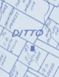 | Details | Standard Blueprint Map and Engineering Company | 1925 |
| Oilfield cadastral map of Atascosa County, Texas |
|
Standard Blueprint Map and Engineering Company |
|
| 1925 |
| LOC:300 |
| $0.00 | Standard-Blueprint-Map-and-Engineering-Company | Oilfield-cadastral-map-of-Atascosa-County--Texas | SOLD
<br></br>
Large, scarce, unrecorded 1920's blue-line oilfield map of Atascosa County, Texas from the period of the early Texas oil boom that started with the Spindletop discovery near Beaumont, Texas in 1901. This antique thematic map shows land owners and locations for petroleum exploration in Atascosa County, Texas. Noted towns include Pleasanton, Campbellton, Ditto, Poteet, Amphion, Somerset and Gallinas. Includes several manuscript notations about oil wells in pencil and red crayon.
<br></br>
Note: Due to the large size the posted image is a composite of two photographs stitched together. Some misalignment or fuzziness may appear at the center join line as a result of this process.
<br></br>
A legend explains the types of oil exploration sites as:
<div class="indenttextblocksingle">
<ul style="list-style-type: circle;">
<li>Location</li>
<li>Rig Up</li>
<li>Drilling</li>
<li>Producing</li>
<li>Gas</li>
<li>Dry Hole</li>
<li>Abandoned Well</li>
<li>Abandoned Location</li>
</ul>
</div>
Map was printed on heavy paper by the Standard Blueprint Map and Engineering Company 515 Main Street, Fort Worth Texas in the mid-1920s. Bears several owner's red ink hand stamps that read: "Return to H. N. Harris, Fort Worth Nat'l Bank Building Fort Worth, Texas." Several lawsuits of the period reference a H.N. Harris, possibly associated with H.N. Harris Company or Inland Oil Company. |