| | Thumbnail | | Creator | Date | Title / Author / Date / Location | Price | | | Description |
| 656 | 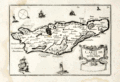 | Details | Tassin, Christophe Nicholas | 1634 |
| Carte de l'Isle de Oleron |
|
Tassin, Christophe Nicholas |
|
| 1634 |
| LOC:4 |
| $160.00 | Tassin--Christophe-Nicholas | Carte-de-l-Isle-de-Oleron | Small, attractive map of the island of Oleron in the Bay of Biscay in Western France, just off the coast in the Atlantic Ocean. Oleron is France's second largest island, after Corsica.
<br></br>
Shows a great deal of interior detail as small as individual buildings, churches, windmills, and gardens. This map is a variant similar to but substantially different from the version published by Tassin in "Les Plans et profils de toutes les principales villes et lieux considerables de France" . This more scarce version contains a compass rose, the cartouche appears at bottom right, and the ships and interior island details are different.
<br></br>
Published by Tavernier in one of the many small-sized atlases created by Christophe Nicholas Tassin (d. 1660) . Tassin's background was as a military engineer, and he is best known for his nautical atlas of 30 sheets, dedicated to Richelieu, documenting France's coastline. Tassin's works contain topographic maps, often of militarily important sites, either sketched on site, composed from firsthand drawings by military engineers, or sometimes borrowed from other mapmakers. Plate 30. |
| 660 | 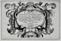 | Details | Tassin, Christophe Nicholas | 1634 |
| Cartes Generale et Particulieres de toutes le costes de France |
|
Tassin, Christophe Nicholas |
|
| 1634 |
| LOC:1 |
| $475.00 | Tassin--Christophe-Nicholas | Cartes-Generale-et-Particulieres-de-toutes-le-costes-de-France | Extraordinary engraved and very scarce 13" x 9" sea-atlas title page by French cartographer Christophe Nicholas Tassin. Contains scrollwork, angels, garlands, and a flat frog-like creature. A beautiful example of 17th century copperplate engraved art. This title page is not from the common series of town views in pocket atlas format published by Tassin.
<br></br>
This title page is from the earliest sea atlas published in France ( 1634 ) by Christophe Tassin. That atlas of 32 plates depicts hydrographic and topographic details of the French coast.
<br></br>
See this site for charts in Tassin's rare atlas: http://gallica.bnf.fr/ark:/12148/btv1b77100033.
<br></br>
Attribution at bottom reads: "Par Sieur Tassin Geographe ordinaire de ca Majeste. Par Privilege du Roy." Tassin's background was as a military engineer. Tassin's work contains topographic maps, often of militarily important sites, either sketched on site, composed from firsthand drawings by military engineers, or sometimes borrowed from other mapmakers. Additionally, Christophe Tassin also published several small sized atlases with profiles of French towns and maps of the provinces.
<br></br>
Published in Paris by Chez Melchior Tavernier, en lisle du Palais, vis à vis la quay de la Megisserie. |
| 739 | 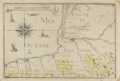 | Details | Tassin, Christophe Nicholas | 1634 |
| Antique Chart of the Guyenne and Biscay Coasts |
|
Tassin, Christophe Nicholas |
|
| 1634 |
| LOC:0 |
| $0.00 | Tassin--Christophe-Nicholas | Antique-Chart-of-the-Guyenne-and-Biscay-Coasts | SOLD
<br></br>
Antique engraved and very scarce 380 year-old chart of the Basque Region (coastal areas of Spain and France directly north of the Pyrenees mountains) by French cartographer Christophe Nicholas Tassin. The chart was published in 1634 as part of Tassin's "Cartes Generale et Particulieres de toutes le costes de France Tant de la Mer Oceane que Mediterranee"... Coverage includes the "Coste de Guyenne" (archaic name for the Aquitaine region of France) with Saint-Jean-de-Luz, Biarritz ,and Bayonne, France. In Spain, San Sebastien, Pasaia (le Pasage), Hondarribia (Funtarabie) on the Biscayan Coast.
<br></br>
This rare antique chart is not from the common series of town views in pocket atlas format published by Tassin but from the earliest atlas of charts specifically of coastal areas published by Tassin in France ca. 1634. Contains a beautifully designed and intricately engraved compass rose with sixteen points. Surrounded by small sailing vessels and a fantastical sea monster.
<br></br>
See
<a href="http://gallica.bnf.fr/ark:/12148/btv1b77100033. " target="_blank">this page</a> at the Bibliotheque national de France for all the maps in Tassin's scare coastal atlas.
<br></br>
Nicholas Tassin's background included a long period of employment as a military engineer and his printed works often show militarily important sites, either sketched on site, composed from firsthand drawings by military engineers, or sometimes borrowed from other mapmakers. Additionally, Tassin also published several small sized atlases with inspired profiles of French towns and maps of the provinces.
<br></br>
Published in Paris: Chez Melchior Tavernier, en lisle du Palais, vis à vis la quay de la Megisserie. |
| 1205 | 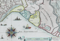 | Details | Tassin, Christophe Nicholas | 1634 |
| Antique coastal map of the Captainerie de Agde and Coast of Languedoc |
|
Tassin, Christophe Nicholas |
|
| 1634 |
| LOC:7 |
| $480.00 | Tassin--Christophe-Nicholas | Antique-coastal-map-of-the-Captainerie-de-Agde-and-Coast-of-Languedoc | Scarce antique engraved, 380 year-old map of the <b>Languedoc</b> region (coastal areas of France including the Camargue with villages of Montpellier, Aigues-Mortes, and La Motte) by French cartographer Christophe Nicholas Tassin. Contains a beautifully designed and intricately engraved compass rose with 32 points. Decorated with small sailing vessels (including a galley) and a <b>fantastical sea monster</b>. Scrollwork distance scale in French lieue.
<br></br>
This rare antique map is not from the common series of town views in pocket atlas format published by Tassin but from the earliest atlas of charts specifically of coastal areas published by Tassin in France ca. 1634: "Cartes Generale et Particulieres de toutes le costes de France Tant de la Mer Oceane que Mediterranee"...
<br></br>
See
<a href="http://gallica.bnf.fr/ark:/12148/btv1b77100033. " target="_blank">this page</a> at the Bibliotheque national de France for all the maps in Tassin's scare coastal atlas.
<br></br>
Attribution at bottom reads: "Par Sieur Tassin Geographe ordinaire de ca Majeste. Par Privilege du Roy." Tassin's background was as a military engineer and his works often show militarily important sites, either sketched on site, composed from firsthand drawings by military engineers, or sometimes borrowed from other mapmakers. Additionally, Christophe Tassin also published several small sized atlases with profiles of French towns and maps of the provinces.
<br></br>
Published in Paris by Chez Melchior Tavernier, en lisle du Palais, vis à vis la quay de la Megisserie. |
| 655 | 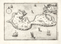 | Details | Tassin, Christophe Nicholas | 1634 |
| Isle de Noirmoutier |
|
Tassin, Christophe Nicholas |
|
| 1634 |
| LOC:0 |
| $0.00 | Tassin--Christophe-Nicholas | Isle-de-Noirmoutier | SALE IS PENDING
<br></br>
Small, attractive map of the island of Noirmoutier, France in the Pays de Loire region of Western France, just off the coast in the Atlantic Ocean. Price includes standard international shipping.
<br></br>
The map shows a great deal of interior detail as small as individual buildings, churches, windmills, and gardens. Offshore, small sailing vessels fill up the empty space. This map is a variant similar to but substantially different from the version published by Tassin in "Les Plans et profils de toutes les principales villes et lieux considerables de France" . This more scarce version contains a compass rose, the cartouche appears at top right, and the ships and interior island details are different. This version of the map is also a variant of the copy held by the Bibliothèque nationale de France. Plate 28.
<br></br>
Published by Tavernier in one of the many small-sized atlases created by Christophe Nicholas Tassin (d. 1660) . Tassin's background was as a military engineer, and he is best known for his nautical atlas of 30 sheets, dedicated to Richelieu, documenting France's coastline. Tassin's work contains topographic maps, often of militarily important sites, either sketched on site, composed from firsthand drawings by military engineers, or sometimes borrowed from other mapmakers. |
| 1360 | 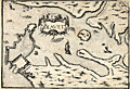 | Details | Tassin, Christophe Nicholas | 1636 |
| Antique map of the Port of Blavet, France |
|
Tassin, Christophe Nicholas |
|
| 1636 |
| LOC:0 |
| $0.00 | Tassin--Christophe-Nicholas | Antique-map-of-the-Port-of-Blavet--France | SOLD
<br></br>
Antique copper-plate engraved map of the Port of Blavet by C.N. Tassin. The map covers a small area in the southern Brittany region of France, near Lorient at the mouth of the Canal du Blavet. One of the earlest available maps to feature a plan of the Citadelle de Port-Louis, built in the 16th century. Alain Mallet's engraving titled "Plan de la Ville et du Fort de Blavet" is amost an exact copy of Tassin's earlier work.
<br></br>
Archivally matted. With mat measures 12" W x 10" H.
<br></br>
Published in the small-sized atlas "Les Plans et profils de toutes les principales villes et lieux considerables de France" by Christophe Nicholas Tassin (d. 1660) . Tassin's background was as a military engineer, and he is best known for his nautical atlas of 30 sheets, dedicated to Richelieu, documenting France's coastline. Tassin's work contains topographic maps, often of militarily important sites, either sketched on site, composed from firsthand drawings by military engineers, or sometimes borrowed from other mapmakers. |
| 983 | 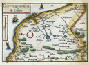 | Details | Tassin, Christophe Nicholas | 1636 |
| Antique map of the Calais, France environs by Tassin |
|
Tassin, Christophe Nicholas |
|
| 1636 |
| LOC:7 |
| $110.00 | Tassin--Christophe-Nicholas | Antique-map-of-the-Calais--France-environs-by-Tassin | Antique map by Nicolas Tassin of the vicinity around Calais, France on the English Channel. Key features include the towns of Calais and Ardres and the Riviere de Graveline. The map is dotted with numerous smaller villages. Sailing ships cruise offshore, a typical decorative feature of Tassin's maps.
<br></br>
Published in the small-sized atlas "Les Plans et profils de toutes les principales villes et lieux considerables de France" by Christophe Nicholas Tassin (d. 1660) . Tassin's background was as a military engineer, and he is best known for his nautical atlas of 30 sheets, dedicated to Richelieu, documenting France's coastline. Tassin's work contains topographic maps, often of militarily important sites, either sketched on site, composed from firsthand drawings by military engineers, or sometimes borrowed from other mapmakers. |
| 152 | 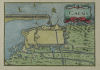 | Details | Tassin, Christophe Nicholas | 1636 |
| Calais |
|
Tassin, Christophe Nicholas |
|
| 1636 |
| LOC:7 |
| $110.00 | Tassin--Christophe-Nicholas | Calais | Antique engraved view of the town and harbor of Calais, France by the author of an atlas on French towns and villages- Christophe Nicolas Tassin. This small copperplate engraving focuses on the nearby area surrounding the town of Calais, its fortifications, and hydraulic plan. With a decorative title cartouche of two sea serpents.
<br></br>
Published in the small-sized atlas "Les Plans et profils de toutes les principales villes et lieux considerables de France" by Christophe Nicholas Tassin (d. 1660) . Tassin's background was as a military engineer, and he is best known for his nautical atlas of 30 sheets, dedicated to Richelieu, documenting France's coastline. Tassin's work contains topographic maps, often of militarily important sites, either sketched on site, composed from firsthand drawings by military engineers, or sometimes borrowed from other mapmakers. |
| 1359 | 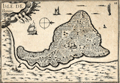 | Details | Tassin, Christophe Nicholas | 1636 |
| Antique map of the Isle de Bouin, France |
|
Tassin, Christophe Nicholas |
|
| 1636 |
| LOC:0 |
| $80.00 | Tassin--Christophe-Nicholas | Antique-map-of-the-Isle-de-Bouin--France | Decorative antique island map of Bouin, France- an island, located in the Breton marshes that exists no more. Created by Nicolas Tassin in 1636, this neat small map shows what was the <b>Isle of Bouin</b> , a commune in the western Pays de la Loire region of France. At the time of our map Tassin shows almost every square foot covered with houses, roads, or ponds.
<br></br>
Archivally matted. With mat measures 12" W x 10" H.
<br></br>
The isle of Bouin no longer exists as such because over time the narrow channel separating the island from the mainland silted up, and the island became part of the mainland. The town of Bouin still exists.
<br></br>
Published in the small-sized atlas "Les Plans et profils de toutes les principales villes et lieux considerables de France" by Christophe Nicholas Tassin (d. 1660) . Tassin's background was as a military engineer, and he is best known for his nautical atlas of 30 sheets, dedicated to Richelieu, documenting France's coastline. Tassin's work contains topographic maps, often of militarily important sites, either sketched on site, composed from firsthand drawings by military engineers, or sometimes borrowed from other mapmakers. |
| 140 | 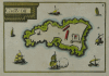 | Details | Tassin, Christophe Nicholas | 1636 |
| Chateau d'If |
|
Tassin, Christophe Nicholas |
|
| 1636 |
| LOC:0 |
| $0.00 | Tassin--Christophe-Nicholas | Chateau-d-If | SOLD<BR> </BR>
Scarce antique island map by Nicolas Tassin from 1636. Highly decorative map shows the island fortress, Chateau d'If, on the island of If located in the Bay of Marseilles, close offshore from the town of Marseilles. The engraving shows the island, surrounded by numerous galleys and other sailing vessels. At the time this engraving was made Marseille was the primary Mediterranean base for the French Corps des Galeres.
<br></br>
Published in the small-sized atlas "Les Plans et profils de toutes les principales villes et lieux considerables de France" by Christophe Nicholas Tassin (d. 1660) . Tassin's background was as a military engineer, and he is best known for his nautical atlas of 30 sheets, dedicated to Richelieu, documenting France's coastline. Tassin's work contains topographic maps, often of militarily important sites, either sketched on site, composed from firsthand drawings by military engineers, or sometimes borrowed from other mapmakers. |
| 141 | 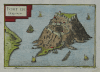 | Details | Tassin, Christophe Nicholas | 1636 |
| Fort de Brigancon |
|
Tassin, Christophe Nicholas |
|
| 1636 |
| LOC:4 |
| $195.00 | Tassin--Christophe-Nicholas | Fort-de-Brigancon | Scarce antique island map by Christophe N. Tassin from 1636. Depicts the Fort of Bregancon near Toulon which is the official retreat for the President of France. The island today looks very much the same as this copperplate engraved view created more than 360 years ago .
<br></br>
Published in the small-sized atlas "Les Plans et profils de toutes les principales villes et lieux considerables de France" by Christophe Nicholas Tassin (d. 1660) . Tassin's background was as a military engineer, and he is best known for his nautical atlas of 30 sheets, dedicated to Richelieu, documenting France's coastline. Tassin's work contains topographic maps, often of militarily important sites, either sketched on site, composed from firsthand drawings by military engineers, or sometimes borrowed from other mapmakers. |
| 149 | 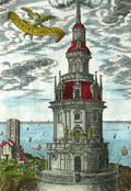 | Details | Tassin, Christophe Nicholas | 1636 |
| Tour de Corduan |
|
Tassin, Christophe Nicholas |
|
| 1636 |
| LOC:0 |
| $350.00 | Tassin--Christophe-Nicholas | Tour-de-Corduan | <b>A recommended item</b> for any collector of maritime, lighthouse, or nautical antiques. Should appeal to collectors of coastal charts of France. Very unusual and quite interesting engraving from Tassin who produced almost exclusively charts and plans of the French coast and little else.
<br></br>
Extremely scarce antique view of the lighthouse "Tower of Corduan" ca. 1636 after an earlier work by Claude Châtillon in 1612. The "Tour de Corduan" is the oldest lighthouse in France and one of the oldest lighthouses in the world. The structure was completed in 1611, more than 35 years after its initial design by Louis de Foix.
<br></br>
Sometimes called the King of Lighthouses because of its large size and extravagant construction details, Le Phare Corduan marks the entrance to the Gironde river near Royan, France. As is common with Tassin engravings numerous sailing vessels are shown offshore the lighthouse, with one firing a blast from its cannon.
<br></br>
Published in the small-sized atlas "Les Plans et profils de toutes les principales villes et lieux considerables de France" by Christophe Nicholas Tassin (d. 1660) . Tassin's background was as a military engineer, and he is best known for his nautical atlas of 30 sheets, dedicated to Richelieu, documenting France's coastline. Tassin's work contains topographic maps, often of militarily important sites, either sketched on site, composed from firsthand drawings by military engineers, or sometimes borrowed from other mapmakers. |
| 999 | 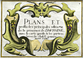 | Details | Tassin, Christophe Nicholas | 1636 |
| Antique title page for Dauphiné province in France |
|
Tassin, Christophe Nicholas |
|
| 1636 |
| LOC:50 |
| $95.00 | Tassin--Christophe-Nicholas | Antique-title-page-for-Dauphiné-province-in-France | Beautiful hand-colored, engraved sectional title page for Tassin's small atlas of French towns. This example is for the chapter containing the province of Dauphiné, in southeastern France. This title page with its scrollwork cartouche is topped with a whimical insect head. A very fine example of 17th century engraving craftsmanship and artistry.
<br></br>
Published in the small-sized atlas "Les Plans et profils de toutes les principales villes et lieux considerables de France" by Christophe Nicholas Tassin (d. 1660) . Tassin's background was as a military engineer, and he is best known for his nautical atlas of 30 sheets, dedicated to Richelieu, documenting France's coastline. Tassin's work contains topographic maps, often of militarily important sites, either sketched on site, composed from firsthand drawings by military engineers, or sometimes borrowed from other mapmakers. |
| 1000 | 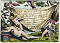 | Details | Tassin, Christophe Nicholas | 1636 |
| Antique title page for Tassins French town atlas |
|
Tassin, Christophe Nicholas |
|
| 1636 |
| LOC:0 |
| $0.00 | Tassin--Christophe-Nicholas | Antique-title-page-for-Tassins-French-town-atlas | SOLD<br></br>
Beautiful antique title page for the "Premiere Partie" or first part of Tassin's small atlas of French towns. This hand-colored copper-engraved title page shows cherubs stretching a sheet bearing the title over a sleeping nude female figure. Resting near the nude are a globe, backstaff (an early navigational instrument), and a compass, each reflecting Tassin's interest in cartography. A substantially fine example of 17th century engraving craftsmanship and artistry.
<br></br>
Published in the small-sized atlas "Les Plans et profils de toutes les principales villes et lieux considerables de France" by Christophe Nicholas Tassin (d. 1660) . Tassin's background was as a military engineer, and he is best known for his nautical atlas of 30 sheets, dedicated to Richelieu, documenting France's coastline. Tassin's work contains topographic maps, often of militarily important sites, either sketched on site, composed from firsthand drawings by military engineers, or sometimes borrowed from other mapmakers. |
| 1365 |  | Details | Tassin, Christophe Nicholas | 1638 |
| NOT AVAILABLE Magnificent Antique Map of the Coast of Provence, France |
|
Tassin, Christophe Nicholas |
|
| 1638 |
| LOC:0 |
| $0.00 | Tassin--Christophe-Nicholas | NOT-AVAILABLE-------Magnificent-Antique-Map-of-the-Coast-of-Provence--France | What a stunning and special map! Spectacular large nautical map of the coastline of Provence, France and Languedoc. Beautiful decorative map (1638) by Christophe Nicolas Tassin shows the French coastline from Port-de-Bouc to Nice. Includes a large, decorative title cartouche, 18 galleys and other sailing vessels, several sea monsters and three gorgeous compass roses. Done in a style somewhat unique to Tassin, with outlandish creatures comprising the cartouches and numerous ships and aquatic sea monsters filling the empty spaces on the map.
<br></br>
In 3 sheets joined, now restored and laid to linen. Without the attribution to Tassin "Geographe ordinaire" or the date.
<br></br>
Tassin's background was as a military engineer. Tassin's work contains topographic maps, often of militarily important sites, either sketched on site, composed from firsthand drawings by military engineers, or sometimes borrowed from other mapmakers. Additionally, Christophe Tassin also published several small sized atlases with profiles of French towns and maps of the provinces.
<br></br>
A very early map from Tassin who authored the first atlas of the French coast "Cartes Generale et Particulieres de toutes le costes de France" in 1634. This map from Tassin's "Les cartes generales de toutes les provinces de France royaumes et provinces de l'Europe. Revues corrigées & augmentées par le Sieur Tassin geographe ordinaire de sa Magesté" |