| | Thumbnail | | Creator | Date | Title / Author / Date / Location | Price | | | Description |
| 5155 | 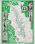 | Details | Texas Street Guide Service | 1969 |
| Rare map of Toledo Bend Reservoir with beauty pageant contestants 1969 |
|
Texas Street Guide Service |
|
| 1969 |
| LOC:63 |
| $0.00 | Texas-Street-Guide-Service | Rare-map-of-Toledo-Bend-Reservoir-with-beauty-pageant-contestants-1969 | SOLD
<br></br>
A classic bait-shop fishing-map poster for Toledo Bend Reservoir, containing photographs of contestants for a beauty pageant swimsuit competition, almost certainly the Miss Toledo Bend pageant. The map provides a documentary record of the numerous businesses that dotted the roads and highways along the shores and approaches to the Toledo Bend Reservoir in 1969, the year that the power plant at the Toledo Bend Dam (northeast of Burkeville) began operating.
<br></br>
Hundreds of businesses and other points of interest are identified in circular call-outs. The locations include:
<div class="indenttextblocksingle">
<ul style="list-style-type: circle;">
<li>Catfish House Motel and Cafe</li>
<li>Chambers Bait House Welding</li>
<li>Shamrock Marina</li>
<li>Huxley Bay Marina</li>
<li>Starlight Motel</li>
<li>Ford's Camp Boats, Bait and Tackle</li>
<li>Hook's Fishing Camp</li>
<li>Kickapoo No. 1 Café, Station, and Grocery</li>
</ul>
</div>
Toledo Bend Reservoir is located on the Sabine River spanning the border between Texas and Louisiana. The Toledo Bend Project, with an area of 185,000 acres and shoreline of 1,200 miles, was constructed primarily for the purposes of water supply, hydroelectric power generation, and recreation.
<br></br>
Published by Bill Hydrick, owner of the Texas Street Guide Service, P.O. Box 1043, Marshall, Texas. Map number 11. Map revised February 1969 (dated within). |