| | Thumbnail | | Creator | Date | Title / Author / Date / Location | Price | | | Description |
| 1200 | 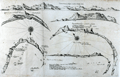 | Details | Thevenot, Melchisedech | 1663 |
| Rare chart of Table Bay and the Bay of Saldagne |
|
Thevenot, Melchisedech |
|
| 1663 |
| LOC:0 |
| $0.00 | Thevenot--Melchisedech | Rare-chart-of-Table-Bay-and-the-Bay-of-Saldagne | SOLD<br></br>
Very scarce mid 17th-century antique copper engraving including 6 coastal elevation views of anchorages and bays favored by Dutch and French vessels on their way to Asia.
<br></br>
These views include:<br></br>
Two views of the coast of Sierra Leone, Africa "Tagrin" opposite Freetown-
<div class="indenttextblock">
<ul style="list-style-type: circle;">
<li> "Carte de Serlionne, ou Tagrin a vue lieue et demie d'elle"</li>
<li>Quatriesme ance de la coste ancreage ordinaire de François. </li>
</ul>
</div>
A view of the coast of Aceh on the northern coast of Sumatra and a further unidentified anchorage "Baye de l'Encau".
<div class="indenttextblock">
<ul style="list-style-type: circle;">
<li>Poulo clauis</li>
</ul>
</div>
A view of the African coast including the Bay of Saldagne and Table Bay.
<div class="indenttextblock">
<ul style="list-style-type: circle;">
<li>Figure de la Terre de Saldagne</li>
</ul>
</div>
A coastal view at Tiku in West Sumatra. <div class="indenttextblock">
<ul style="list-style-type: circle;">
<li>Figure de la Rade de Ticou en l-isle de Sumatra <br />
(Identifies the two mountains of Pagaman and Priaman with Ticou nestled below. Interesting descriptions of 7 points on the view include "Illets a pigouins de table bay"- An island with penguins.)</li>
</ul>
</div>
This creaky old chart truly reflects its likely origins in the commercial world, perhaps first published privately by the VOC. The charts are characterized by a scarcely used 360 degree birds-eye oblique coastal view.
<br></br>
Melchisédech (or Melchisédec) Thévenot (c. 1620 – 1692) was a French author, scientist, traveler, and cartographer. Thévenot was the inventor of the spirit level and is also famous for his popular 1696 book- The Art of Swimming.
<br></br>
Many of Thévenot's maps were published in his Relations de Divers Voyages Curieux (Paris, 1663), a collection of translations of voyages of discovery. |