| | Thumbnail | | Creator | Date | Title / Author / Date / Location | Price | | | Description |
| 1437 | 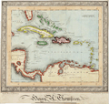 | Details | Thompson, Henry A. | 1850 |
| Manuscript naval student map of the Caribbean Islands |
|
Thompson, Henry A. |
|
| 1850 |
| LOC:0 |
| $0.00 | Thompson--Henry-A- | Manuscript-naval-student-map-of-the-Caribbean-Islands | SOLD <br></br>
Original mid 19th-Century manuscript map in black ink and watercolor, showing southern Florida, islands of the Caribbean/West Indies and part of Central and South America. Set within an elaborate border.
<br></br>
The creator has signed the map "Henry A. Thompson" and inscribed it "Elson House Academy / near Gosport June 9, 1850". "Near Gosport" suggests that Thompson may have drawn this map while aboard ship, perhaps during a summer training cruise.
<br></br>
It is likely that Henry Thompson was a student at a naval preparatory training establishment, as Gosport, near Portsmouth in Hampshire was a major sea port on the south coast of England at this time. The introduction in 1838 of an entrance examination for the Royal Navy, encouraged the development of specialised educational establishments like Elson House Academy, Dr. Burney's Academy, and nearby Stubbington House School. |