| | Thumbnail | | Creator | Date | Title / Author / Date / Location | Price | | | Description |
| 191 |  | Details | Tofino de San Miguel | 1786 |
| Plano Geometrico de la Bahia de Algeciras y Gibraltar |
|
Tofino de San Miguel |
|
| 1786 |
| LOC:0 |
| $0.00 | Tofino-de-San-Miguel | Plano-Geometrico-de-la-Bahia-de-Algeciras-y-Gibraltar | SOLD<br></br>
Scarce original Spanish antique nautical chart from Captain Vincente Tofiño de San Miguel y Van der Walle (1732-1795), Director of the Spanish Naval Academy in Cadiz. This old sea chart of the Bay of Gibraltar and Algeciras was one of 47 published in 1786 as part of the first scientific Spanish sea atlas: 'Atlas Maritimo de España' (Maritime Atlas of Spain) by the Dirección de Hidrografía, Spain's equivalent to the U.S. Coast Survey. Prior to the late 18th century Spain jealously guarded nautical maps and charts of its possessions, especially so for its overseas colonies.<br></br>
Attractive title cartouche at upper left contains a legend that identifies several dozen landmarks in and around the Bay of Gibraltar. <br></br>
Unlike other 18th century antique nautical charts that focus primarily on the coastal outline around the bay of Gibraltar, this old sea chart is notable for the extensive detailed engraving that is used to illustrate inland topographical details. This detail on inland areas, which is also evident in contemporary British charts from the same era (e.g. Faden), is likely related to the emphasis on land forces used in battles that occurred in this strategic location. During the siege of British occupied Gibraltar by Spanish and French forces during 1779 - 1783 , Spain and its allies are said to have fielded 35,000 ground troops in addition to the tens of thousands of sailors and marines aboard its naval fleet (80,000 spectators are said to have watched the grand assault of 1782 from locations in the surrounding hills). |
| 187 | 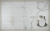 | Details | Tofino de San Miguel | 1788 |
| Carta Esferica de una Parte del Oceano Atlantico |
|
Tofino de San Miguel |
|
| 1788 |
| LOC:54 |
| $850.00 | Tofino-de-San-Miguel | Carta-Esferica-de-una-Parte-del-Oceano-Atlantico | Scarce, 18th century antique nautical chart published as part of the first scientific Spanish sea atlas: 'Atlas Maritimo de España' (Maritime Atlas of Spain) by the Dirección de Hidrografía, Spain's equivalent to the U.S. Coast Survey. This antique small-scale copperplate engraved chart by the renowned Spanish hydrographer Don Vincente Tofino de San Miguel (1732-1795) covers the coast of Spain and of Africa as far south as Cape Verde. Includes Cape Verde islands, Canary islands, the Azores. Coverage of the Western Mediterranean includes the Balearic islands with Ibiza, Mallorca ( Majorca ), and Minorca ( Menorca ).
<BR> </BR>
Picturesque dedicatory cartouche to Frey Don Antonio Valdes engraved by D. Fernando Selma includes palm trees, an anthropomorphic lion and two rabbits overlooked by crumbling columns bearing the inscribed national motto "Plus Ultra". |
| 4963 | 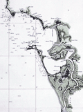 | Details | Tofino de San Miguel | 1789 |
| Antique Map of Cadiz Spain and Cape Trafalgar |
|
Tofino de San Miguel |
|
| 1789 |
| LOC:57 |
| $1,450.00 | Tofino-de-San-Miguel | Antique-Map-of-Cadiz-Spain-and-Cape-Trafalgar | Finely engraved and printed scarce original Spanish antique nautical chart of Cadiz, Spain and environs from Captain Vincente Tofiño de San Miguel y Van der Walle (1732-1795), Director of the Spanish Naval Academy in Cadiz. Manuscript pencil notations in English below the title cartouche suggest use aboard an English-speaking vessel.
<br></br>
This antique nautical chart of covering Cadiz, Spain to Cape Trafalgar was one of 47 charts published in 1789 as part of the first scientific Spanish sea atlas: 'Atlas Maritimo de España' (Maritime Atlas of Spain) by the Dirección de Hidrografía, Spain's equivalent to the U.S. Coast Survey. Prior to the late 18th century Spain jealously guarded nautical maps and charts of its possessions, especially so for its overseas colonies.
<br></br>
Drawn by Bauza. Grabado en Madrid por Joaquin Ballester. |