| | Thumbnail | | Creator | Date | Title / Author / Date / Location | Price | | | Description |
| 5283 | 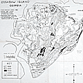 | Details | Torrey, Bill Sr. | 1956 |
| Rare privately published map of Ossabaw Island, Georgia |
|
Torrey, Bill Sr. |
|
| 1956 |
| LOC:10 |
| $750.00 | Torrey--Bill-Sr- | Rare-privately-published-map-of-Ossabaw-Island--Georgia | Rare, a privately-published first edition map of Ossabaw Island, Georgia from 1956 with roads, woods, ponds, marsh, and artesian wells as the chief focus. Contains an inset map showing the generalized coastline from Savannah to Brunswick, Georgia. Just behind the Egg Islands, at the north end of Ossabaw Island, Torrey's Landing is simply labeled "Boat House". Two additional maps on the verso.
<br></br>
The map was created and privately published by William F. "Bill" Torrey Sr., the son of Henry Torrey and Nell Ford Torrey who purchased the island in 1924. Bill Torrey Sr. ran a timber operation and a cattle business, Circle T. Ranch, on Ossabaw Island in the 1950's. The cattle business Torrey operated was no doubt the reason that the location of artesian wells on the island was considered as a key data point.
<br></br>
Together the three maps were designed for use by visitors to the island, providing route details from the DeSoto hotel in Savannah, GA to the Torrey Dock at Vernon View (verso); then from the dock to St. Catherine's Sound and Ossabaw Sound (verso). Once visitors had docked at Torrey Landing boat house the map (recto) served as a guide to the entire island. This map, by Torrey who knew the island well, is the reference source for place names and island locations on more recent maps. Source (DuBose, Elizabeth. Executive Director, Ossabaw Island Foundation. June, 2020. Personal communication.)
<br></br>
Ossabaw Island is Georgia's third largest barrier island, with 26,000 acres total - 9,000 acres of high ground. Ossabaw is bounded by the Atlantic Ocean to the east; the Bear River/ Florida Passage of the Intracoastal Waterway to the west; the Ogeechee River to the north; and, St. Catherine’s Sound to the south. |