| | Thumbnail | | Creator | Date | Title / Author / Date / Location | Price | | | Description |
| 1286 | 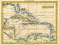 | Details | Tryer, James | 1822 |
| Antique map of the Caribbean Sea and the Spanish Main |
|
Tryer, James |
|
| 1822 |
| LOC:5 |
| $195.00 | Tryer--James | Antique-map-of-the-Caribbean-Sea-and-the-Spanish-Main | Antique map of the West Indies at the beginning of the 19th century by James Tryer. The area covered stretches from Florida in the north the Gulf of Darien in the south and from the Yucatan peninsula in the west to the Orinoco river in the east. Includes portions of the Atlantic Ocean, Gulf of Mexico, Caribbean Sea, Pacific Ocean, and Sea of Honduras. The northern coast of South America is labeled "The Spanish Main".
<br></br>
James Tyrer was a prolific engraver from Pentonville, London who flourished during the early part of the nineteenth century. This neat map was published by John Souter in Clark's A New General School Atlas in 1822. |