| | Thumbnail | | Creator | Date | Title / Author / Date / Location | Price | | | Description |
| 426 |  | Details | U.S. Army Engineers | 1878 |
| Water Routes from Norfolk to the Cape Fear River |
|
U.S. Army Engineers |
|
| 1878 |
| LOC:0 |
| $0.00 | U-S--Army-Engineers | Water-Routes-from-Norfolk-to-the-Cape-Fear-River | SOLD
<BR> </BR>
Attractive map of the Virginia and North Carolina coasts including the Outer Banks. This 130 year-old hand-colored lithograph from the Army Corps of Engineers accompanied the Chief Engineer's report to the U.S. 46th Congress. Key cities and features include Pamlico Sound and River (spelled Pamplico), Wilmington, Cape Lookout, Cape Hatteras, Washington D.C., Albemarle Sound, the Dismal Swamp Canal, Norfolk, and the entrance to Chesapeake Bay. Numerous lighthouses and inlets dot this 15" x 22" late 19th century chart. <BR> </BR>
With a table of distances in statute miles. Senate Document Number 73. Surveyed under the direction of Captain Charles B. Phillips. Drawn by G.P. Strums. |
| 5239 |  | Details | U.S. Army Engineers | 1878 |
| Early U.S. Flow Map Tonnage Chart of Coastwise Commerce |
|
U.S. Army Engineers |
|
| 1878 |
| LOC:3 |
| $320.00 | U-S--Army-Engineers | Early-U-S--Flow-Map-Tonnage-Chart-of-Coastwise-Commerce | Scarce thematic <b>flow map</b> of the United States west coast: California, Oregon, and Washington. An early institutional example of a "flow map" used for the U. S. Government. The flow map was first used less than 40 years earlier by Charles-Joseph Minard after his earlier formative use line width to display the attrition of French troops during Napoleon's Russian campaign of 1812.
<br></br>
<div class="indenttextblocksingle">
The chart shows the volume (tonnage) of maritime trade from all points south of San Francisco to ports along the U.S. West Coast. The use for the chart was to support the decision-making process for selecting a new harbor of refuge and breakwater on the Pacific Ocean between the Strait of Juan de Fuca and San Francisco.
<br></br>
Tonnage Chart of Coastwise Commerce North of San Francisco -California
<br></br>
From "Harbor of Refuge on the Pacific Coast Appendix PP of the Annual report to the Chief of Engineers for 1881. Washington: Government Printing Office. 1881. |
| 383 | 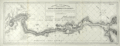 | Details | U.S. Army Engineers | 1893 |
| Barataria and Lake Borgne Levee Districts 1893 |
|
U.S. Army Engineers |
|
| 1893 |
| LOC:0 |
| $0.00 | U-S--Army-Engineers | Barataria-and-Lake-Borgne-Levee-Districts-1893 | SOLD
<BR> </BR>
Draftsman-style map of the lower Mississippi River from New Orleans to the Mississippi River passes. Depicts the levees constructed along the Mississippi River in the 1892-1893 season. The map names levee improvements circa 1893 in Orleans, St. Bernard, Jefferson and Plaquemines parishes with Mississippi river mileage from Cairo, Illinois shown at 5 mile intervals. New Orleans is shown as it existed in 1893 with the northern half of the city to Lake Ponchartrain yet to be developed. <BR> </BR>
Key points along the river that are identified include Southwest Pass, the Jump, Tropical Bend, Devils Plate, Fort Jackson and English Turn. Lines of latitude and longitude. Plate VII. Dated June 1, 1893. <BR> </BR> |
| 1478 |  | Details | U.S. Army Engineers | 1894 |
| Barataria and Lake Borgne Levee Districts 1894 |
|
U.S. Army Engineers |
|
| 1894 |
| LOC:0 |
| $90.00 | U-S--Army-Engineers | Barataria-and-Lake-Borgne-Levee-Districts-1894 | Draftsman-style map of the lower Mississippi River from New Orleans to the Mississippi River passes. Depicts the levees constructed along the Mississippi River from June 1894. The map names levee improvements circa 1894 in Orleans, St. Bernard, Jefferson and Plaquemines parishes with Mississippi river mileage from Cairo, Illinois shown at 5 mile intervals. New Orleans is shown as it existed in 1894 with the northern half of the city to Lake Ponchartrain yet to be developed.
<BR> </BR>
Key points along the river that are identified include Southwest Pass, the Jump, Tropical Bend, Devils Plate, Fort Jackson and English Turn. Lines of latitude and longitude. Plate VII. Dated June, 1894. <BR> </BR> |
| 5340 | 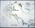 | Details | U.S. Army Engineers | 1899 |
| Chart of the Mouth of the Columbia River |
|
U.S. Army Engineers |
|
| 1899 |
| LOC:88 |
| $275.00 | U-S--Army-Engineers | Chart-of-the-Mouth-of-the-Columbia-River | Antique hand-colored chart of the mouth of the Columbia River. From a survey made June 1899 by the U.S. Army Corps of Engineers. Includes Astoria, Oregon; Youngs Bay, Clatsop Spit, Sand Island, Chinook River, Cape Disappointment, and Fort Stevens. Emphasis of the chart is on the south jetty (built 1884) near Clatsop Spit with hundreds of depth soundings at the Columbia River bar and just beyond there offshore.
<br></br>
The Columbia River comprises most of the border between the U.S. states of Washington and Oregon. At 1,243 miles long the Columbia is the largest river in the Pacific Northwest. The Columbia River bar is very dangerous with over 2,000 wrecks recorded since 1792. The U.S. Coast Guard operates a National Motor Lifeboat School at Cape Disappointment to the north of the Columbia River mouth. |
| 4859 | 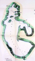 | Details | U.S. Army Engineers | 1901 |
| Antique charts of Lakes Tohopekaliga Hatcheneha and Cypress Florida |
|
U.S. Army Engineers |
|
| 1901 |
| LOC:0 |
| $0.00 | U-S--Army-Engineers | Antique-charts-of-Lakes-Tohopekaliga-Hatcheneha-and-Cypress-Florida | SOLD
<br></br>
One page with three charts of Lake Tohopekaliga, Cypress lake, and Lake Hatcheneha (Hatchineha) Florida. This antique chart was produced by the U.S. Engineer's Office Tampa, Florida December 14, 1901.
<br></br>
The three lakes are part of a larger chain of lakes and canals known as the Kissimmee Waterway. Boaters can travel the 56-mile long waterway connecting Lake Tohopekaliga to the north to Lake Okeechobee to the south, passing through Cypress Lake and Lake Hatchineha and along the Kissimmee River through a series of canals and man-made locks. Lakes in the Waterway’s upper basin are fairly shallow with average depths ranging from 6 to 13 feet. (https://www.sfwmd.gov/sites/default/files/documents/kisswaterway.pdf)
<br></br>
The chart of Lake Tohopekaliga (Tohopeka) includes numerous soundings and identifies key locations including:
<br></br>
<div class="indenttextblocksingle">
<ul style="list-style-type: circle;">
<li>Edgewater Landing</li>
<li>Shingle Creek</li>
<li>Town of Kissimmee</li>
<li>Fish Lake Canal North Branch</li>
<li>St. Elmo Landing</li>
<li>St. Cloud Canal</li>
<li>McCool's Landing</li>
<li>Poorhouse Landing</li>
<li>Lee's Landing</li>
<li>Southport Canal</li>
<li>Edgewater Landing</li>
<li>Paradise, Flemings, and Cypress Islands</li>
</ul>
</div>
Date and initials at bottom left within "W.F.J. 10-25-90 (1890)" |
| 5129 | 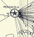 | Details | U.S. Army Engineers | 1929 |
| Port of Pensacola, Florida scarce photomosaic and two maps |
|
U.S. Army Engineers |
|
| 1929 |
| LOC:0 |
| $300.00 | U-S--Army-Engineers | Port-of-Pensacola--Florida-scarce-photomosaic-and-two-maps | Small booklet of 66 pages that includes 3 cartographic artifacts related to Pensacola, Florida.
<div class="indenttextblocksingle">
<ul style="list-style-type: circle;">
<li>Mosaic Composed of Aerial Photographs Pensacola Florida. Made by Air Service, U.S. Army 4th Photo Section. Dec. 22, 1922.</li>
<li>Origin of Imports and Destination of Exports Pensacola, Fla. 1928. Quantities expressed in cargo tons of 2240 lbs. and shown thus. 1929.</li>
<li>Port Facilities at Pensacola, Fla. 1929.</li>
</ul>
</div>
Along with many data tables and additional photographs the contents of the entire booklet include:
<div class="indenttextblocksingle">
<ul style="list-style-type: circle;">
<li>Port and Harbor Conditions</li>
<li>Port Customs and Regulations</li>
<li>Port Services and Charges</li>
<li>Fuel and Supplies</li>
<li>Port and Harbor Facilities</li>
<li>Communications</li>
<li>The freight rate situation</li>
<li>Commerce of the port</li>
<li>The territory tributary to the port</li>
<li>General</li>
</ul>
</div>
War Department Corps of Engineers and United States Shipping Board Port Series No. 3 Part 2 THE PORT OF PENSACOLA, FLORIDA.
Printed by the U.S. Government Printing Office, Washington, D.C. 1929. Price when issued 30 cents. |
| 5061 |  | Details | U.S. Army Engineers | 1960 |
| Two maps of recreation facilities on the Okeechobee Waterway. |
|
U.S. Army Engineers |
|
| 1960 |
| LOC:87 |
| $150.00 | U-S--Army-Engineers | Two-maps-of-recreation-facilities-on-the-Okeechobee-Waterway- | Two charts of recreation facilities on the Okeechobee Waterway stretching across the state from East Florida to West Florida. Recto with a map of recreation facilities including locks and dams along the Caloosahatchee River from Pine Island Sound to Moore Haven on Lake Okeechobee. Includes the Ortona Lock and Dam and the Franklin Lock and Dam.
<br></br>
Verso with a map of Lake Okeechobee and the Okeechobee waterway outlet to the Atlantic Ocean at Stuart, Florida. Published by the U.S. Army Corps of Engineers, Jacksonville District. |