| | Thumbnail | | Creator | Date | Title / Author / Date / Location | Price | | | Description |
| 5282 | 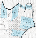 | Details | U.S. Congress | 1837 |
| Antique plat of lands Choctaw Point Lighthouse Mobile Bay Alabama |
|
U.S. Congress |
|
| 1837 |
| LOC:10 |
| $275.00 | U-S--Congress | Antique-plat-of-lands-Choctaw-Point-Lighthouse-Mobile-Bay-Alabama | Scarce plat map of land near Mobile, Alabama from 1837 to support the published opinion of Benjamin Franklin Butler, Attorney General of the United States (1833-1838) in a case dated August 5, 1837. The plat shows the Mobile River at right with Choctaw Point Lighthouse. Lot contains 2 page of legal opinion, supported by the plat, probably from a report to Congress.
<br></br>
Choctaw Point is located on the west bank of the Mobile River about one mile south of downtown Mobile and one mile SW of the U.S.S. Alabama memorial. A brick lighthouse (63' Fixed light), visible for 15 miles, existed at Choctaw Point from 1831 until the beginning of the Civil War. The American Lighthouse Guide of 1845 found the light of little use in navigating the Dog River.
<div class="indenttextblocksingle">
"To mail steamers and bay craft familiar with the shoals, and Choctaw Pass, this light is a valuable aid in dark nights, but of little benefit to strangers. This light is of little utility in consequence of forming too great an angle in its bearing from the courses required through the intricate and narrow channels of the river and passes." (Mills, Robert. The American Light-house Guide: with Sailing Directions, for the Use of the Mariner. 1845. p. 11)
</div>
Among the land holdings near Choctaw Point that are identified in the map are plots belonging to Antoine Espijo, John Forbes & Co., Regist Burnady, Simon Favre, and John Murrill. |
| 5094 |  | Details | U.S. Congress | 1891 |
| Map supplement showing boundaries of congressional districts in 1891 |
|
U.S. Congress |
|
| 1891 |
| LOC:2001 |
| $300.00 | U-S--Congress | Map-supplement-showing-boundaries-of-congressional-districts-in-1891 | Scarce volume of maps and population statistics for 1880 and 1890 published as a supplement to the congressional directory. Maps show counties/parishes and boundaries of congressional districts.
<br></br>
With exceptions noted below, 43 maps show all the states admitted to the Union as of 1890. The following states are not mapped as they had not been admitted to the Union: Arizona, New Mexico, Utah, Oklahoma, District of Columbia, Alaska, Hawaii.
<br></br>
By W.H. Michael, Clerk of Printing Records. Washington. Government Printing Office. 1891. 123 pages. |