| | Thumbnail | | Creator | Date | Title / Author / Date / Location | Price | | | Description |
| 4925 | 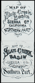 | Details | U.S. Geological Survey | 1873 |
| Pair of mining maps for Slate Creek Basin, California |
|
U.S. Geological Survey |
|
| 1873 |
| LOC:13 |
| $270.00 | U-S--Geological-Survey | Pair-of-mining-maps-for-Slate-Creek-Basin--California | Two rare original antique mining maps of the northern and southern part of Slate Creek Basin in Sierra County California. Both maps show placer mine (stream-bed mining) locations with company names, Chinese mining camps, tunnel locations, hydraulic mines, dwelling houses, waterways and proposed tunnels.
<br /><br />
Shows many ditches and labeled wagon roads including the "wagon road from La Port to Queen City."
<br /><br />
Mining companies include Yankee Hill Placer Mines, Maria Hartman Company, Alturas Gold Mining Company, Indian Queen Company, and Poverty Point Placer Mines. |
| 340 |  | Details | U.S. Geological Survey | 1892 |
| Mouth of the Mississippi River |
|
U.S. Geological Survey |
|
| 1892 |
| LOC:0 |
| $0.00 | U-S--Geological-Survey | Mouth-of-the-Mississippi-River | SOLD
<BR> </BR>
Small antique lithographed chart of the Mouth of the Mississippi River. The chart, from the U.S. Geological Survey, is derived from a U.S. Coast Survey chart and overlaid with hachured topographic details. Lighthouses, soundings, life saving stations and navigational aids are shown. Water shown in blue. Some of the features shown include Lake Ponchartrain, Timbalier Pass, Bayou Lafourche, Pass Fourchon, Chandeleur Islands, Biloxi, and Pass Christian. <BR> </BR>
Produced for the U.S. Geological Survey Thirteenth Annual Report. Produced by George S. Harris Lithographers, Philadelphia. Plate 22. |
| 341 |  | Details | U.S. Geological Survey | 1892 |
| Turtle Harbor Florida |
|
U.S. Geological Survey |
|
| 1892 |
| LOC:3 |
| $75.00 | U-S--Geological-Survey | Turtle-Harbor-Florida | Small lithographed antique chart of Key Largo and Turtle Harbor Florida. The chart, from the U.S. Geological Survey, is derived from a U.S. Coast Survey chart and overlaid with hachured topographic details. Lighthouses, soundings, and navigational aids are shown. Water shown in blue. Some of the features shown include Pumpkin Key, Carysfort Reef, Angelfish Key, and Palo Alto Key. <BR> </BR>
Produced for the U.S. Geological Survey Thirteenth Annual Report. Produced by George S. Harris Lithographers, Philadelphia. Plate 36. |
| 342 |  | Details | U.S. Geological Survey | 1892 |
| Marquesas Keys (Florida) |
|
U.S. Geological Survey |
|
| 1892 |
| LOC:0 |
| $0.00 | U-S--Geological-Survey | Marquesas-Keys-(Florida) | SOLD
<br></br>
Small lithographed chart of Marquesas Keys, Florida. This antique chart, from the U.S. Geological Survey, is derived from a U.S. Coast Survey chart (no. 70) and overlaid with hachured topographic details. Soundings, and navigational aids are shown. Water shown in blue. Some of the features shown include Couch Key and Round Island. <BR> </BR>
Produced for the U.S. Geological Survey Thirteenth Annual Report. Produced by George S. Harris Lithographers, Philadelphia. Plate 36. |
| 343 |  | Details | U.S. Geological Survey | 1892 |
| Delta at Caesars Creek (Florida) |
|
U.S. Geological Survey |
|
| 1892 |
| LOC:3 |
| $75.00 | U-S--Geological-Survey | Delta-at-Caesars-Creek-(Florida) | Small lithographed antique chart of the area around Caesars Creek, on the southeast coast of Florida. The chart, from the U.S. Geological Survey, is derived from a U.S. Coast Survey chart (no. 66) and overlaid with hachured topographic details. Soundings, and navigational aids are shown. Water shown in blue. Some of the features shown include Elliott Key, Rubicon Key, Tottens Key, and Reids Key, Adams Key. <BR> </BR>
Produced for the U.S. Geological Survey Thirteenth Annual Report. Produced by George S. Harris Lithographers, Philadelphia. Plate 42. |
| 337 |  | Details | U.S. Geological Survey | 1892 |
| Provincetown Harbor |
|
U.S. Geological Survey |
|
| 1892 |
| LOC:0 |
| $0.00 | U-S--Geological-Survey | Provincetown-Harbor | SOLD
<br><br/>
Small antique lithographed nautical chart of northern Cape Cod, Provincetown, Massachusetts and the harbor derived from U.S. Coast Survey chart No. 10 and overlaid with topographic details. Lifesaving stations, lighthouses, soundings, and navigational aids are shown. Water shown in blue. Features include Race Point, Wood End Light, Long Point Light, and Peaked Hill Bar lifesaving station. <BR> </BR>
Produced for the U.S. Geological Survey Thirteenth Annual Report. Produced by George S. Harris Lithographers, Philadelphia. Plate 35. |
| 339 |  | Details | U.S. Geological Survey | 1892 |
| Entrance to San Francisco Bay |
|
U.S. Geological Survey |
|
| 1892 |
| LOC:3 |
| $140.00 | U-S--Geological-Survey | Entrance-to-San-Francisco-Bay | Small antique lithographed chart of the Entrance to San Francisco Bay. The chart, from the U.S. Geological Survey, is derived from a U.S. Coast Survey chart and overlaid with hachured topographic details. Lighthouses, soundings, life saving stations and navigational aids are shown. Water shown in blue. Some of the features include the Golden Gate (entrance to the bay), Ballenas Bay, Alcatraz Island, San Bruno, Point Lobos, and Pt. San Pedro. <BR> </BR>
Produced for the U.S. Geological Survey Thirteenth Annual Report. Produced by George S. Harris Lithographers, Philadelphia. Plate 45. |
| 6451 | 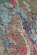 | Details | U.S. Geological Survey | 1935 |
| Fine large Geologic Map of Colorado |
|
U.S. Geological Survey |
|
| 1935 |
| LOC: |
| $500.00 | U-S--Geological-Survey | Fine-large-Geologic-Map-of-Colorado | Original large folding Geologic Survey Map of Colorado [1] from 1935, dissected and laid to linen. With an inset index map of Colorado. Includes an impressive table of the principal sources of geologic data that were used to compile the map of Colorado, USA. Published by the Department of the Interior, U.S. Geological Survey.
<br><br>
Scarce in this format. Type of rock (igneous, metamorphic, sedimentary) is indicated by color keyed to an extensive index scattered across the right side of the map.<br><br>
[1] Geologic Map of Colorado by the United States Geological Survey W. C. Mendenhall Director in cooperation with the Colorado State Geological Survey Board and Colorado Metal Mining Fund 1935. |