| | Thumbnail | | Creator | Date | Title / Author / Date / Location | Price | | | Description |
| 648 |  | Details | Valentijn, Francois | 1720 |
| Amboina, Seram, and Malaku Islands |
|
Valentijn, Francois |
|
| 1720 |
| LOC:0 |
| $880.00 | Valentijn--Francois | Amboina--Seram--and-Malaku-Islands | Scarce antique Dutch chart of part of the Maluku (Molucca) island chain in Indonesia (the Spice Islands). Includes Buru Island ( Boero ), Amboin, Seram (Ceram) , Banda, and many other smaller islands. The chart is comprised of two conjoined sheets making up the seldom available 29" wide chart of the region. On watermarked chain-laid paper.
<br></br>
From François Valentyn's Oud en Nieuw Oost Indien (Old and New East India), part V : Beschryving van Coromandel, Pegu, Arrakan, Bengale, Mocha, Persien, Malakka, Sumatra, Ceylon. François Valentijn (1666-1727) was a missionary who worked at Amboina from during the late 17th and early 18th centuries. With numerous rhumb lines and two compass roses topped with fleur-de-lis. Plate 1. |
| 4854 | 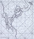 | Details | Valentijn, Francois | 1720 |
| Surat, India |
|
Valentijn, Francois |
|
| 1720 |
| LOC:9 |
| $900.00 | Valentijn--Francois | Surat--India | Scare Dutch chart of the Tapti River and Surat, India. This fine antique chart shows Surat then partially surrounded by a wall and the Casteel Suratta or Surat Castle (built 1546). The author provides numerous depth soundings and great detail on sandbanks in the Tapti River. Such rich detail suggests the source of information on the chart had a significant amount of experience in the area.
<br></br>
From contemporaneous accounts we know that Suratte was a key trading center.
<div class="indenttextblocksingle">
"At one end of the City of Suratte upon the very banks of the river called Tapty you see a very fair castle with four large towers of free-stone with a broad ditch always full of water…there are here three great factories, to wit: of the French, English and Dutch East India Companies, each of which are distinguished by their banners of their respective nations which are to be seen on the tops of their houses."
<br></br>
"But when any European ships arrive at this port, the Persians, Indians, Armenians, and Turks, plant their tents or booths in such numbers, as to give it the resemblance of a very handsome fair." (Rennefort, Crull, Dellon. A Voyage to the East Indies… 1698. Google Books. Online)
</div>
<br></br>
From François Valentyn's Oud en Nieuw Oost Indien (Old and New East India), part V : Beschryving van Coromandel, Pegu, Arrakan, Bengale, Mocha, Persien, Malakka, Sumatra, Ceylon. François Valentijn (1666-1727) was a missionary who worked at Amboina from during the late 17th and early 18th centuries. With numerous rhumb lines and two compass roses topped with fleur-de-lis. Plate 9. |
| 875 | 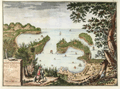 | Details | Valentijn, Francois | 1724 |
| Antique Dutch View of Acapulco Harbor in Mexico |
|
Valentijn, Francois |
|
| 1724 |
| LOC:0 |
| $0.00 | Valentijn--Francois | Antique-Dutch-View-of-Acapulco-Harbor-in-Mexico | SOLD
<br></br>
Fascinating antique panoramic view of the harbor of <b>Acapulco, Mexico</b> ("Aquapulco") from the early eighteenth century. This copperplate-engraved view has a legend at bottom left corner keyed to six locations on the scene:
<div class="indenttextblock">
<ul>
<li>Acapulco village</li>
<li>Fort San Diego (with latitude and longitude coordinates)</li>
<li>Grote mont. (harbor entrance)</li>
<li>Punta el Grifo</li>
<li>Kleyne mont. (channel between the mainland and la Roqueta island)</li>
<li>Haven van Marques (Puerto Marques Bay)</li>
</ul>
</div>
This colorful old view of the Acapulco area is by <b>Francois Valentijn</b> (or Valentyn) from 'Oud en Nieuw Oost Indien' published from Amsterdam in 1724 by Joannes van Braam. Valentijn ( 1666–1727 ) was a Dutch minister and naturalist who worked in the East Indies for the V.O.C. (Vereenigde Oost-Indische Compagnie). It is likely that Valentijn's access to V.O.C. maps and documents provided much source material for the eight volumes with over one thousand engravings. However, the basis for this relief map of Acapulco is an earlier watercolor by Dutch artist Johannes Vingboons who derived his work from drawings made in New Spain by Juan Gómez de Trasmonte and Adrian Boot before 1628.
<div class="indenttextblock"> (Connolly, Priscilla. "Vingboons, Trasmonte and Boot: European Cartography of Mexican Cities in the Early Seventeenth Century". 2014. <a href="http://www.researchgate.net/publication/249029290_Vingboons_Trasmonte_and_Boot_European_Cartography_of_Mexican_Cities_in_the_Early_Seventeenth_Century">Internet</a>)</div>
<br></br>
Two interesting graphical elements are the compass atop the title block at left which gives the orientation of the site and also in the far right bottom corner is a barely visible image of a woodsman with axe, removing a limb from the tall tree. |
| 4843 | 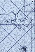 | Details | Valentijn, Francois | 1726 |
| Antique Dutch Chart of the Environs of Cape Town South Africa |
|
Valentijn, Francois |
|
| 1726 |
| LOC:9 |
| $825.00 | Valentijn--Francois | Antique-Dutch-Chart-of-the-Environs-of-Cape-Town-South-Africa | For collectors. Very old, scarce chart of the South African west coast from the Bay of Saldanha including Table Bay (Taefel Bay), False Bay, and Sout Bay all surrounding the Cabo de Boa Esperanca or Cape of Good Hope now the location of Cape Town, South Africa. By Dutch minister Francois Valentijn (Valentyn).
<br></br>
Only two sales recorded in the AMPR, none in the last 15 years. #43.
<br></br>
From Francois Valentijn's labor of seven years, the <b>Oud en Nieuw Oost-Indië</b>, considered the best source for reference material related to Asia for a period of almost two hundred years. |