| | Thumbnail | | Creator | Date | Title / Author / Date / Location | Price | | | Description |
| 193 | 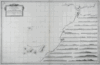 | Details | Varelay Ulloa, Joseph | 1787 |
| Carta Esferica de la Costa de Africa |
|
Varelay Ulloa, Joseph |
|
| 1787 |
| LOC:54 |
| $600.00 | Varelay-Ulloa--Joseph | Carta-Esferica-de-la-Costa-de-Africa | This rare, engraved antique nautical chart of the Northwest coast of Africa was published as part of the first scientific Spanish sea atlas: 'Atlas Maritimo de España' (Maritime Atlas of Spain) by the Dirección de Hidrografía, Spain's equivalent to the U.S. Coast Survey. The antique chart was authored by Spanish naval Captain Don Joseph Varelay Ulloa (ca. 1743-1794) who made several hydrographic surveys of the coast of Africa. With manuscript pencil plots from 1808 centered on Madeira. <BR> </BR>
Coverage from Cape St. Vincent past the Strait of Gibraltar to Cape Bojador in the south including the Canary Islands. Inset with 20 detailed coastal profile views. |