| | Thumbnail | | Creator | Date | Title / Author / Date / Location | Price | | | Description |
| 1323 | 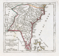 | Details | Vaugondy, Robert de | 1749 |
| Interesting antique map of Florida and the Carolinas |
|
Vaugondy, Robert de |
|
| 1749 |
| LOC:11 |
| $280.00 | Vaugondy--Robert-de | Interesting-antique-map-of-Florida-and-the-Carolinas | Attractive and fascinating map of south-eastern United States with "Virginie, Caroline, Louisiane, and Floride". Named features include Pensacola, the Bahama Islands, Cape Canaveral, St. Augustine, Saint Simons Island, Tybee Island, Savannah, Charleston, Cape Fear, and the "Montagnes de Apalaches". Florida is depicted as an archipelago of islands as some sources believed at the time. Published by the family of Robert Vaugondy in 1749.
<br></br>
This scarce map is an authentic French copper-plate engraving printed ca. 1749 on a larger 11" x 8.5 inch sheet of old chain-laid paper. |
| 3647 |  | Details | Vaugondy, Robert de | 1772 |
| Antique map on travels of Captain Cluny |
|
Vaugondy, Robert de |
|
| 1772 |
| LOC:88 |
| $180.00 | Vaugondy--Robert-de | Antique-map-on-travels-of-Captain-Cluny | Map by Vaugondy to illustrate the mythical voyage of Captain Cluny. In 1769 Alexander Cluny published "The American Traveler: or, Observations on the Present State, Culture and Commerce of the British Colonies in America, in a Series of Letters... by an Old and Experienced Trader." The map, based on Cluny's supposed observations depicts North America from above the Arctic Circle, to the Gulf of Mexico, including an early exaggerated depiction of present day Alaska.
<br></br>
The most interesting feature is perhaps Cluny's supposed Northwest Passage extending from Repulse Bay to the mythical Arctic Cape Fowler. To the east is Greenland, Iceland, the western part of the European continent, and the northern portion of Africa.
<br></br>
This map is part of the 10 map series prepared by Vaugondy exploring the mapping of North American and specifically the Northwest Passage. The copper-plate engraved map was part of an early study in comparative cartography. |
| 1379 | 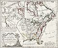 | Details | Vaugondy, Robert de | 1778 |
| Fine Antique Speculative Map of North America |
|
Vaugondy, Robert de |
|
| 1778 |
| LOC:10 |
| $350.00 | Vaugondy--Robert-de | Fine-Antique-Speculative-Map-of-North-America | A good example of Robert de Vaugondy's 1778 map of North America's English Possessions incorporating his speculative geography of the American northwest. The map covers from Hudson Bay to the Gulf of Mexico and from the Atlantic Ocean to Texas, then "Nouveau Mexique".
<br></br>
This map's most interesting features are in the large inset in the upper left quadrant illustrating Vaugondy's speculative geography of the American Northwest. The map features the Sea of the West (Mer de L'Ouest), the discoveries of Admiral de Fonte, the discoveries of Bernarda, the Strait of Anian, and the mythical kingdoms of Quivira and Teguaio.
<br></br>
There is no reliable evidence to authenticate either the existence of Admiral de Fonte himself or of the voyage. The account of de Fonte's voyage, first published in 1708, took the form of a letter by de Fonte in which he described himself as “then Admiral of New Spain and Peru, and now Prince of Chili.” The story is now attributed to the editor of the London Magazine.
<br></br>
Perhaps Vaugondy was attempting a bit of "fake news" and trying to muddy the waters over the English claims to North American territory by including these speculative geographic features into the map.
<br></br>
From Vaugondy's "Nouvel atlas portatif ". Engraved by Dussy. |
| 2563 | 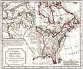 | Details | Vaugondy, Robert de | 1795 |
| Canada. Louisiane. Etats-Unis. |
|
Vaugondy, Robert de |
|
| 1795 |
| LOC:10 |
| $360.00 | Vaugondy--Robert-de | Canada--Louisiane--Etats-Unis- | Uncommon third edition (Delamarche) of Vaugondy's map with changed title cartouche and "corrigés par le Cen.Lamarche son successeur" added to title.
<br></br>
Several changes are notable for this later edition as compared to Vaugondy's 1778 issue. For Florida,new locations are recorded at Saint Augustine and Cape Canaveral. Two maps on one sheet- east and west coasts.
<br></br>
The map of the western part of North America is most notable for it's depiction of Mer de L'Quest or Sea of the West. A great sea, easily the size of the Mediterranean, to flow from the then-known Strait of Juan de Fuca. Shows an opening to the ocean from this great sea at roughly in North California or Oregon and Quivira somewhere in Idaho.
<br></br>
Martha's Vineyard is named as "Martins Viniard". Many Indian Tribes and French Forts located in the Old Northwest and west of the Mississippi. Florida is depicted as an Archipelago.
<br></br>
Dated to 1795, the 3rd year of the French Republic. |