| | Thumbnail | | Creator | Date | Title / Author / Date / Location | Price | | | Description |
| 57 | 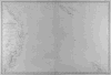 | Details | Vincedon-Dumoulin | 1858 |
| Carte de la Cote Orientale de la Nouvelle Hollande |
|
Vincedon-Dumoulin |
|
| 1858 |
| LOC:59 |
| $1,100.00 | Vincedon-Dumoulin | Carte-de-la-Cote-Orientale-de-la-Nouvelle-Hollande | Fine engraved lines define geographic boundaries in this copperplate engraved antique French navigational chart of Eastern Australia, the Great Barrier Reef, the Coral Sea, New Caledonia, and North New Zealand. Based on the voyages of French explorer Dumont D'urville in the 1820's and 1830's . <BR> </BR>
Contains the circular anchor stamp of the Depot General de la Marine. With a black over-stamp for Cartes de la Marine Impériale. Debrie Libraire au Harve, Seul Depositaire. Price: two Francs. Plate 1. Edition of 1858. |
| 53 | 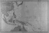 | Details | Vincedon-Dumoulin | 1865 |
| Carte Generale de l'Ocean Pacifique |
|
Vincedon-Dumoulin |
|
| 1865 |
| LOC:0 |
| $0.00 | Vincedon-Dumoulin | Carte-Generale-de-l-Ocean-Pacifique | This chart is SOLD. <BR> </BR>
French navigational chart of Japan, Southern China and the Pacific Islands including New Guinea, Solomon Islands, Borneo, Samoa, Tonga, and many more. Based on the voyages of French explorer Dumont D'Urville in the 1820's and 1830's . With a black over-stamp for Cartes de la Marine Impériale. Debrie Libraire au Harve, Seul Depositaire. Price: two Francs. Plate 1. Edition of 1865. |