| | Thumbnail | | Creator | Date | Title / Author / Date / Location | Price | | | Description |
| 4979 | 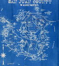 | Details | Washington Map and Blueprint Company | 1895 |
| Cyanotype map of San Juan County, Washington state |
|
Washington Map and Blueprint Company |
|
| 1895 |
| LOC:88 |
| $475.00 | Washington-Map-and-Blueprint-Company | Cyanotype-map-of-San-Juan-County--Washington-state | Early blueprint (cyanotype) map of the San Juan Islands including Stuart Island, Waldron Island, Orcas Island, Shaw Island, Blakely Island, Lopez Island, San Juan Island and many more. Numerous water features include the Canal de Haro, San Juan Channel, President Channel, Rosario Strait, Strait of Juan de Fuca, and Thatcher Passage. Manuscript notations in red for several parcels of land on Orcas Island and Lopez Island.
<br></br>
Scarce. With detached fragmentary front cover of map. Price when issued 50 cents.
<br></br>
By the Washington Map and Blueprint Company, 607-11 Pacific Block, Seattle, Washington. That company was the successor to the O.P. Anderson Map and Blueprint Company, Engineers and Draughtsmen. Established 1885.
<br></br>
Printed by Lowman and Hanford Stationery and Printing Company. |