| | Thumbnail | | Creator | Date | Title / Author / Date / Location | Price | | | Description |
| 6435 | 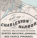 | Details | Weiss, Jacob | 1861 |
| Map of Charleston Harbor |
|
Weiss, Jacob |
|
| 1861 |
| LOC:10 |
| $2,150.00 | Weiss--Jacob | Map-of-Charleston-Harbor | Unrecorded edition of "Map of Charleston Harbor [South Carolina] showing the location of forts ..." printed by Jacob Weiss at 600 Chestnut Street, Philadelphia in 1861. Inset elevation or perspective view of Charleston at top.
<br><br>
My interpretation of the map suggests Weiss printed the map between December 27, 1860, when the Union surrendered Shutes Folly/Castle Pinckney to the S.C. militia but before April 12, 1861 when the Confederacy began bombardment of Union forces at Fort Sumter. During this period the public had an intense interest in the building conflict.
<br><br>
Shows the main channel from the Atlantic Ocean to Charleston docks. Circles represent the range of cannon fire from forts and batteries in vicinity of Charleston Harbor, Charleston, South Carolina. Key features include:
<div class="indenttextblocksingle">
<ul style="list-style-type: circle;"></li>
<li>Shutes Folly Island with Castle Pinckney</li>
<li>Rebellion Road [2]</li>
<li>US Arsenal</li>
<li>Customs House</li>
<li>Mount Pleasant</li>
<li>Sullivan's Island</li>
<li>Drunken Dick Breakers</li>
<li>Fort Johnson and Fort Sumter</li>
</ul>
</div>
WorldCat shows only two similar institutional holdings - Hagley Museum & Library, and University of Michigan Clements Library. This edition is similar to the edition at the U. Michigan Clements Library but lacks the price, and the Clements copy lacks both the decorative border, and the "Perspective View of the Harbor and City of Charleston" at top.
<br><br> |