| | Thumbnail | | Creator | Date | Title / Author / Date / Location | Price | | | Description |
| 1243 | 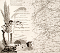 | Details | Wells and Harris | 1798 |
| Scarce 18th century map of the River Thames with roads, rivers, and canals |
|
Wells and Harris |
|
| 1798 |
| LOC:0 |
| $0.00 | Wells-and-Harris | Scarce-18th-century-map-of-the-River-Thames-with-roads--rivers--and-canals | SOLD<BR></BR>
Scarce and attractive 3 foot long antique map of the <b>River Thames</b> from its mouth to its source at the Severn River. This marvelously detailed beauty records the transportation routes near the Thames River and London at the end of the 18th century. Mail coach roads, common stage roads, rivers and canals are meticulouly recorded and may be identifed by referring to a visual index at top left. All market towns are notated with the number of miles they lie from the Royal Exchange (Ex: Salisbury 84; Chippenham 96; Colchester 51). Major canals are named and annotated with their year of construction (Ex: Basingstoke Canal 1772; Braunston Grand Junction Canal 1793).
<br></br>
<b>No record of a sale of this map is found in the Antique Map Price Record (AMPR)</b> nor are any examples of the map for sale or catalogued online except for ONE COPY recorded at the British Library.
<br></br>
Scenic cartouche at right showns a tranquil, shady scene with water gushing out of a tunnel, overflowing a spillway
<br></br>
Published March 10, 1798 by L.B. Wells, No 26 Leadenhall Street J. Harris Sweetings Alley Royal Exchange and at No. 54 Tottenham Court Road. |