| | Thumbnail | | Creator | Date | Title / Author / Date / Location | Price | | | Description |
| 5173 | 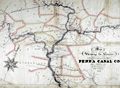 | Details | Wierman Jr., T. T. | 1876 |
| Map Showing the Canals Belonging to the Pennsylvania Canal Company. |
|
Wierman Jr., T. T. |
|
| 1876 |
| LOC:200 |
| $1,150.00 | Wierman-Jr---T--T- | Map-Showing-the-Canals-Belonging-to-the-Pennsylvania-Canal-Company- | Manuscript thematic surveyor's map from 1876 detailing the visible hydrographic features of east central Pennsylvania with numerous rivers, creeks and canals. The map's theme is the canals belonging to the Pennsylvania Canal Company.
<br></br>
The map was probably used to generate blueprint copies and dates to the beginning of the decline of the Pennsylvania Canal System. In 1867, the Pennsylvania Railroad formed the Pennsylvania Canal Company using their canals to haul freight. By 1900 most Pennsylvania canal were unused, a victim of the significant financial advantage provided by the railroads
<br></br>
With a finely drawn compass rose with a fleur de lis skewered by a gaily festooned pointer. Also contains much detail about railroads, bridges and towns, a reflection of the company's ownership by a railroad company.
<br></br>
Portions of the waterways are labeled as :
<div class="indenttextblocksingle">
West Branch Division
Juniata Division Penna Canal
Wyoming Division Pennsylvania Canal
Pennsylvania Canal
Union Canal
</div>
The map contains all or part of the following Pennsylvania counties: Blair, Center, Clynton, Huntingdon, Mifflin, Snyder, Juniata, Perry, Cumberland, York, Lancaster, Dauphin, Northumberland, Montou, Columbia, Luzerne, Lycom, Centre.
<br></br>
Drawn by T. T. Wierman Jr. Assistant Engineer. |