| | Thumbnail | | Creator | Date | Title / Author / Date / Location | Price | | | Description |
| 4956 | 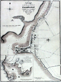 | Details | Wood, John | 1821 |
| Rare Plan of the Town and Harbour of Stornaway Lewis Island |
|
Wood, John |
|
| 1821 |
| LOC:64 |
| $1,999.39 | Wood--John | Rare-Plan-of-the-Town-and-Harbour-of-Stornaway-Lewis-Island | Very scarce antique map of the Harbor at Stornaway on the Island of Lewis, part of the Outer Hebrides Islands of Scotland. An exceptional finely-engraved example of an early 19th century harbor map. By John Woods from his Town Atlas to accompany his "Descriptive Account of the Principal Towns of Scotland…"
<br></br>
With a decorative smaller-scale inset Plan of the Town and Harbor of Stornaway and Projected Improvements. Notable features of the inset plan include Seaforth Lodge, Gallow Hill, Anish, Sandwich Bay, Big Rock, and Sandwich Hill.
<br></br>
Wood described Stornaway as
<div class="indenttextblocksingle">"a considerable thriving town in the Island of Lewis, in the Parish of that name and shire of Ross. The old part of the Town is situated at the head of the Loch of Stornaway, on a point or ness of land jutting into it; the newer parts of the Town stretch to the north and south of this point, along the margins of the Loch." (ibid pp. 545-547).</div> |