| | Thumbnail | | Creator | Date | Title / Author / Date / Location | Price | | | Description |
| 3664 | 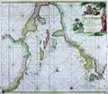 | Details | van Keulen, Johannes | 1687 |
| Surprising Dutch Chart of the West Indies and Gulf Coast |
|
van Keulen, Johannes |
|
| 1687 |
| LOC:51 |
| $0.00 | van-Keulen--Johannes | Surprising-Dutch-Chart-of-the-West-Indies-and-Gulf-Coast | SOLD
<BR> </BR>
Visually disconcerting and exciting Dutch nautical chart of the Gulf Coast and West Indies. This fine and very collectable sea chart is oriented with north to the right. By Johannes van Keulen. Second state. |
| 1065 | 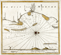 | Details | van Keulen, Johannes | 1753 |
| Scarce Dutch Chart of Kayalpatnam, India |
|
van Keulen, Johannes |
|
| 1753 |
| LOC:6 |
| $350.00 | van-Keulen--Johannes | Scarce-Dutch-Chart-of-Kayalpatnam--India | Scarce antique "secret" coastal chart of "Cayl" ( Kayalpatnam ) on the Gulf of Mannar, near the southern end of the Coromandel Coast (Tamil Nadu) that had long been prosperous from maritime trade and pearl fishing. The area was conquered by the Portuguese in 1548, and taken over by the VOC in 1658. Prior to that time Kayal is referred to in Marco Polo's travel diaries dating to 1250 AD. Kayal was an important trading port dating to the 1st century A.D.
<br></br>
The chart identifies Dutch settlements / churches in the area of <b>Kayalpatnam</b>: Warande Patnam, Ould Cayl, Tolhuys, and Groote Kerk van Pt. Cayl, several topped by the Dutch flag. Insert elevation view facing west of the coast line. The seas feature detailed nautical information, including bathymetric soundings and the locations of sandbars and other navigation hazards.
<br></br>
From the sixth part of van Keuelen's "<b>de Nieuwe Groote Lichtende Zee-Fakkel</b>" based on secret charts of the <b>Dutch East India Company</b> (Vereenigde Oost-Indische Compagnie or <b>VOC</b>). Prior to the mid-18th century these charts were only disseminated in manuscript to safeguard what the VOC considerd to be proprietary trade secrets. The Dutch East India Company was the dominant trade force in Asia for nearly 200 years.
<br></br>
Bears the attribution at bottom: "In't ligt gebragt door Joannes van Keulen". |
| 1086 | 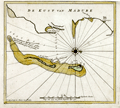 | Details | van Keulen, Johannes | 1753 |
| Scarce Dutch Chart of Tuticorin, India |
|
van Keulen, Johannes |
|
| 1753 |
| LOC:6 |
| $350.00 | van-Keulen--Johannes | Scarce-Dutch-Chart-of-Tuticorin--India | Scarce Dutch Chart of Tuticorin, India on the Gulf of Mannar, India by Johannes van Keulen from 1753. |
| 1085 |  | Details | van Keulen, Johannes | 1753 |
| Scarce Dutch Chart of Phan Rang Bay, Vietnam |
|
van Keulen, Johannes |
|
| 1753 |
| LOC:6 |
| $350.00 | van-Keulen--Johannes | Scarce-Dutch-Chart-of-Phan-Rang-Bay--Vietnam | Scarce "secret" coastal chart of the Bay of Padaran ( vinh Phan Rang ) on the East Sea, north of Cape Padaran and just south of Cam Ranh Bay in Vietnam. Near the center of the chart a river, today's "Song Cai Phan Rang", empties into the bay. Located on the bay today is the city of Phan Rang–Tháp Chàm, also called Panduranga. Oriented with west at the top.
<br></br>
Keulen provides very little interior detail around this Vietnamese bay other than a few palm trees and some low mountains. The seas feature detailed hydrographic data, including depth soundings and the locations of sandbars and other navigation hazards. Two suggested anchorages are noted for VOC vessels, each for a specific wind direction: "Noorder Mouson" and "Zuyder Mouson".
<br></br>
From the sixth part of van Keulen's "<b>de Nieuwe Groote Lichtende Zee-Fakkel</b>" based on secret charts of the <b>Dutch East India Company</b> (Vereenigde Oost-Indische Compagnie or <b>VOC</b>). Prior to the mid-18th century these charts were only disseminated in manuscript to safeguard what the VOC considered to be proprietary trade secrets. The Dutch East India Company was the dominant trade force in Asia for nearly 200 years.
<br></br>
Bears the attribution at bottom: "By Joannes van Keulen". |
| 1087 |  | Details | van Keulen, Johannes | 1753 |
| Scarce Dutch Chart of Cosmoledo Atoll, Seychelles |
|
van Keulen, Johannes |
|
| 1753 |
| LOC:6 |
| $275.00 | van-Keulen--Johannes | Scarce-Dutch-Chart-of--Cosmoledo-Atoll--Seychelles | Rare antique "secret" chart of the raised coral atoll of <b>Cosmoledo</b> of the Aldabra Group, belonging to the Outer Islands of the Seychelles. The name Cosmoledo is said to honor a Portuguese navigator, who was part of Juan de Nova's crew. De Nova was a Galician explorer of the Atlantic and Indian Oceans at the service of Portugal. He is credited as the discoverer of Ascension and Saint Helena islands.
<br></br>
The chart is very sparse showing only a thin circle of land ringing the atoll with five palm trees and a related few notes. No soundings .
<br></br>
From the sixth part of van Keuelen's "<b>de Nieuwe Groote Lichtende Zee-Fakkel</b>" based on secret charts of the <b>Dutch East India Company</b> (Vereenigde Oost-Indische Compagnie or <b>VOC</b>). Prior to the mid-18th century these charts were only disseminated in manuscript to safeguard what the VOC considered to be its proprietary trade secrets. The Dutch East India Company was the dominant trade force in Asia for nearly 200 years.
<br></br>
Bears the attribution at bottom: "In't ligt gebragt door Joannes van Keulen". |