| | Thumbnail | | Creator | Date | Title / Author / Date / Location | Price | | | Description |
| 4805 | 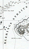 | Details | von Kotzebue, Otto | 1821 |
| Kotzebue Chart of Beerings Straits on Mercators Projection |
|
von Kotzebue, Otto |
|
| 1821 |
| LOC:88 |
| $0.00 | von-Kotzebue--Otto | Kotzebue-Chart-of-Beerings-Straits-on-Mercators-Projection | SOLD
<BR> </BR>
Scarce antique map of the <b>Bering Strait (Beering's Strait)</b> from exploration by <b>Otto von Kotzebue</b> (1787-1846) after the exploration of Russian navigator Vitus Bering. Includes the track and dates of Kotzebue's ship, the brig <b>RURIK</b>, as well as numerous named locations including Kotzebue Sound, Cape Krusentern, the St. Lawrence Islands, Cape Lowenstern, Cape Deceit, and Eschholtz Bay. Von Kotzebue was a German officer in the Imperial Russian Navy.
<br></br>
This fine map is based on von Kotzebue's voyage around Cape Horn to Alaska during the early 19th century. After rounding Cape Horn and visiting Chile, Easter Island, Hawaii, and the Marshall Islands, Kotzebue explored the North American west coast and searched unsuccessfully for a passage to the Arctic Ocean. Graff called the expedition, the second Russian scientific expedition into the Pacific, "one of the great early nineteenth-century voyages of discovery."
<br></br>
The Bering Strait is a strait of the Pacific Ocean, which separates Russia and Alaska south of the Arctic Circle.
<br></br>
Scarce. From Otto von Kotzebue's "A Voyage of Discovery into the South Sea and Beering's Straits, for the Purpose of Exploring a North-East Passage, Undertaken in the Years 1815-1818."
London. Longman, Hurst, Rees, Orme & Brown. 1821.
<br></br>
Printed in 1821 in English, Russian, and German editions. |