| | Thumbnail | | Creator | Date | Title / Author / Date / Location | Price | | | Description |
| 6823 | 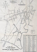 | Details | Harris, Charles E. | 1939 |
| Rare Pictorial Map of Hyannis, Massachusetts Homes of Sea Captains in 1854 |
|
Harris, Charles E. |
|
| 1939 |
| LOC:87 |
| $395.00 | Harris--Charles-E- | Rare-Pictorial-Map-of-Hyannis--Massachusetts-Homes-of-Sea-Captains-in-1854 | A very rare unrecorded historical map of the village of Hyannis, Massachusetts in 1854 showing the locations of sea captains' homes. Copyrighted in 1939 by Dr. Charles E. Harris.
<br><br>
No copies are recorded in WorldCat, nor were any copies found online as of August, 2023.
<br><br>
Includes a alphabetical indexed table of names of sea captains tied numerically to locations Harris has identified on the map. A brief glance at the captains' names makes it apparent that command of Hyannis-based vessels during that time period was largely a familial occupation. Families with the most numerous seafarers included the surnames: Baker (10), Baxter (9) Bearse (23), Crowell (17), Hallett (22), and Lothrop (8). A legend above the table identifies each name with the type of maritime trade each captain was associated with: coastal, deep water, lighthouse service, canal boat, pilot, steamer, and living.
<br><br>
Dated January 1, 1939. Data collected and assembled by Dr. Charles E. Harris. Map courtesy of James F. McLaughlin C.E. Drawn by Walter M. Gaffney. |