| | Thumbnail | | Creator | Date | Title / Author / Date / Location | Price | | | Description |
| 1079 | 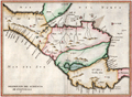 | Details | Herrera y Tordesillas, Antonio de | 1622 |
| Scarce 1622 map of Central America including Costa Rica |
|
Herrera y Tordesillas, Antonio de |
|
| 1622 |
| LOC:10 |
| $600.00 | Herrera-y-Tordesillas--Antonio-de | Scarce-1622-map-of-Central-America-including-Costa-Rica | Scarce map of the "Audiencia" or province of "Guatimala", then comprised of southern Mexico, Honduras, El Salvador, Nicaragua, Costa Rica, and Belize. From "Descripción de la Audiencia de Guatemala, compuesta por el Licenciado Don Antonio de Remesal, del Consejo de Su Majestad, su Oidor y Relator, año de 1618" by Antonio de Herrera y Tordesillas. In the "Descripción de la Audiencia de Guatemala," Herrera y Tordesillas covers a wide range of topics, including the geography and climate of the region, the indigenous peoples who lived there, and the Spanish efforts to establish colonial rule. He also provides detailed accounts of the major cities and towns, as well as the various institutions that made up the colonial administration.
<br></br>
Some of the locations noted on the map include: the Gulf of Fonseca, San Miguel, San Salvador, Santiago de Guatemala, Chiapa de Corzo, Soconusco, the Gulf of Honduras, Puerto Cortes (Puerto de Caballos); Trujillo; and the islands of Coiba and Cébaco, Panama. In Costa Rica, Herrera y Tordesillas identifies among other features: Nicoya, Isla de Chira, Cartago (16 mi. east of San Jose), and El Castillo (near the Arenal volcano). |