| | Thumbnail | | Creator | Date | Title / Author / Date / Location | Price | | | Description |
| 574 |  | Details | Homann, Johann | 1720 |
| Regni Norvegiae Accurata Tabula |
|
Homann, Johann |
|
| 1720 |
| LOC:57 |
| $500.00 | Homann--Johann | Regni-Norvegiae-Accurata-Tabula | Decorative copper-plate engraved antique map of Norway by Johann Baptist Homann (1664-1724) . Homann was a profilmic German cartographer and publisher who was appointed cartographer to the Holy Roman Empire from 1715.
<br></br>
After Homann's death his maps were re-published by his heirs. Homann Heirs (also "Homannianis Heredibus" or "Homann Erben" or "Heritiers de Homann") was a company established after the death of Homann to carry on the publishing business of the firm he started in the early 1700's. The designation "Homann Heirs" appears on maps published by that successor firm from about 1730 to 1848. This antique map does not carry that designation but probably dates to ca. 1742 - 1748.
<br></br>
At bottom left of the map is a highly decorative title cartouche containing the Norwegian state coat of arms, a lion bearing an axe. Beneath that emblem are depicted numerous nymphs cavorting in the sea. |
| 580 | 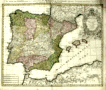 | Details | Homann, Johann | 1745 |
| Regnorum Hispaniae et Portugalliae |
|
Homann, Johann |
|
| 1745 |
| LOC:0 |
| $0.00 | Homann--Johann | Regnorum-Hispaniae-et-Portugalliae | SOLD
<br></br>
Old antique map of Spain and Portugal divided into provinces, with the Balearic Islands of Ibiza, Mallorca ( Majorca ), and Minorca ( Menorca ). Coverage includes the Strait of Gibraltar, southern France and the coast of North Africa. This antique, copperplate engraved map ca. 1745 has old hand color and a decorative title cartouche with coats of arms for many of the provinces shown on the map.
<br></br>
Drawn by famous German cartographer Johann Homann, the antique map was published by the firm Homann Heirs. Homann Heirs (also "Homannianis Heredibus" or "Homann Erben" or "Heritiers de Homann") was a company established after the death of Homann to carry on the map publishing business of the firm he started in the early 1700's. The designation "Homann Heirs" appears on maps published by that successor firm from about 1730 to 1848. |
| 583 |  | Details | Homann, Johann | 1745 |
| Totius Regni Neapolis |
|
Homann, Johann |
|
| 1745 |
| LOC:58 |
| $600.00 | Homann--Johann | Totius-Regni-Neapolis | Map of the southern boot of Italy divided into provinces. Coverage of this antique hand-colored map includes islands of both the Tyrhennian Sea and Adriatic Sea including Capri, Procida, Ischia, Naples ( Napoli ), Stromboli, Lipari, Basilio, the Tremiti Islands and the northern tip of Sicily including Milazzo and the Strait of Messina. Two decorative cartouches give life to the map, one includes a sea serpent, flying horses and numerous putti fencing with epee.
<br></br>
Drawn by famous German cartographer Johann Homann ca. 1720, the map was published later by the firm Homann Heirs. Homann Heirs (also "Homannianis Heredibus" or "Homann Erben" or "Heritiers de Homann") was a company established after the death of Homann to carry on the publishing business of the firm he started in the early 1700's. The designation "Homann Heirs" appears on maps published by that successor firm from about 1730 to 1848. |