| | Thumbnail | | Creator | Date | Title / Author / Date / Location | Price | | | Description |
| 3688 | 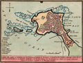 | Details | Luffman, John | 1800 |
| Antique map of Cadiz, Spain engraved for Luffman's Select Plans |
|
Luffman, John |
|
| 1800 |
| LOC:13 |
| $220.00 | Luffman--John | Antique-map-of-Cadiz--Spain-engraved-for-Luffman-s-Select-Plans | Fine copper-plate engraved plan of Cadiz, Spain not far from the Strait of Gibraltar. As described by Luffman: <div class="indenttextblock">
"Cadiz. The capital of Andalusia and the commercial capital of Old Spain is situated on the northern extremity of the Isle of Leon and Surrounded by an irregular fortification, but its best defence are the breakers by which it is nearly environed. Latitude 36 30 North. Longitude 6, 40 West from London"
</div>
</BR>
From "Luffman's Select Plans of the Principal Cities, Harbors, Forts etc. in the World". Engraved and published by John Luffman, No. 28 Little Bell Alley, Coleman Street, Cheapside, London. November 1, 1800. Volume I, Number 67.
<br></br>
Luffman also provided similar engravings to this at about the same time for J.T. Serres' "The Little Sea Torch: or, True Guide for Coasting Pilots." Serres translated the Little Sea Torch from an earlier illustrated coasting pilot guide, based on Bougard's "Le petit flambeau de la mer", first published in 1684.
<br></br>
John Luffman (1751-1821) began his career as an engraver, producing a very large and fine map of Antigua, where he had resided in 1787 and 1789. That map was published by Luffman to accompany his 'A Brief Account of the Island of Antigua', 1788." Luffman shared the same sad fate as many publishers and was declared bankrupt on 9th March, 1793. Moving forward Luffman was more cautious and produced small format atlases and handy-sized maps of the theatres of war, principal towns and cities and battle-plans relating to the Wars of the French directorate and the subsequent Napoleonic War. |
| 4849 | 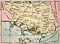 | Details | Luffman, John | 1800 |
| Antique map Morbihan, Brittany, France Luffman's Select Plans |
|
Luffman, John |
|
| 1800 |
| LOC:0 |
| $0.00 | Luffman--John | Antique-map-Morbihan--Brittany--France-Luffman-s-Select-Plans | SOLD
<br></br>
An original antique engraved and hand-colored map of the department of Morbihan in Brittany (Bretagne) near the Bay of Biscay, France. Includes the islands of Belle Isle, Hoat, Hoedic, and Dumet. Key cities include Vannes, Rochefort, Quiberon, Auray, and Bernard.
<br></br>
From "Luffman's Select Plans of the Principal Cities, Harbors, Fortresses, etc. in the World". Engraved and published by John Luffman, No. 28 Little Bell Alley, Coleman Street, February 1, 1800. Volume I. #30.
<br></br>
Luffman also provided similar engravings at about the same time for J.T. Serres' "The Little Sea Torch: or, True Guide for Coasting Pilots." Serres translated the Little Sea Torch from an earlier illustrated coasting pilot guide, based on Bougard's "Le petit flambeau de la mer", first published in 1684. Serres added his own magnificent views of headlands, ports, lighthouses, landmarks, topography, coastal scenes, ships and harbor entrances.
<br></br>
John Luffman (1751-1821) began his career as an engraver, trained by John Bayly, a noted map engraver in the Goldsmiths' Company, producing a fine map of Antigua, where he had resided in 1787 and 1789. Luffman shared the same sad fate as many publishers and was declared bankrupt on 9th March, 1793. Moving forward Luffman was more cautious and produced small format atlases and handy-sized maps of the theatres of war, principal towns and cities and battle-plans relating to the Wars of the French directorate and the subsequent Napoleonic War. |
| 3684 | 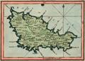 | Details | Luffman, John | 1800 |
| Antique map Belle Isle, France engraved for Luffman's Select Plans |
|
Luffman, John |
|
| 1800 |
| LOC:0 |
| $0.00 | Luffman--John | Antique-map-Belle-Isle--France-engraved-for-Luffman-s-Select-Plans | SOLD
<br></br>
Neat antique engraved map of the Island of Belle Isle in the Bay of Biscay in France. With the headlands shown of Talifer Point, Corigan Point, Poulains Point, Grand Village Point and many more. Many small cities and towns are identified as well as a citadel near the town of Palais.
<br></br>
Key political divisions noted by Luffman include the four parishes of Sauzon, Locmaria, Bangor, and Palais.
<br></br>
From "Luffman's Select Plans of the Principal Cities, Harbors, Forts etc. in the World". Engraved and published by John Luffman, No. 28 Little Bell Alley, Coleman Street, August 1, 1800. Volume I, #54.
<br></br>
Luffman also provided similar engravings at about the same time for J.T. Serres' "The Little Sea Torch: or, True Guide for Coasting Pilots." Serres translated the Little Sea Torch from an earlier illustrated coasting pilot guide, based on Bougard's "Le petit flambeau de la mer", first published in 1684. Serres added his own magnificent views of headlands, ports, lighthouses, landmarks, topography, coastal scenes, ships and harbor entrances.
<br></br>
John Luffman (1751-1821) began his career as an engraver, trained by John Bayly, a noted map engraver in the Goldsmiths' Company, producing a fine map of Antigua, where he had resided in 1787 and 1789. Luffman shared the same sad fate as many publishers and was declared bankrupt on 9th March, 1793. Moving forward Luffman was more cautious and produced small format atlases and handy-sized maps of the theatres of war, principal towns and cities and battle-plans relating to the Wars of the French directorate and the subsequent Napoleonic War. |
| 3689 | 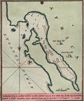 | Details | Luffman, John | 1800 |
| Antique map of Saldanha Bay, South Africa engraved for Luffman's Select Plans |
|
Luffman, John |
|
| 1800 |
| LOC:77 |
| $230.00 | Luffman--John | Antique-map-of--Saldanha-Bay--South-Africa-engraved-for-Luffman-s-Select-Plans | Fine copper-plate engraved plan of Saldanha Bay, South Africa, an important port north of Cape Town. As described by Luffman: <div class="indenttextblock">
"Saldanha Bay, An excellent harbour of Africa fourteen leagues north of Table Bay. In this Bay Lord Keith Captur'd a Dutch squadron under Admiral Lucas. Aug 17, 1796. Lat 33.30 S Longitude 18.20 E of London."
</div>
</BR>
Named after the early 16th-century Portuguese navigator António de Saldanha, the bay is both larger and safer than Table Bay, which is located 65 miles (105 km) farther south-southeast. Saldanha Bay’s former abundance of seals, fish, and guano deposits was long contested between French, English, and Dutch interests, with exploitation restricted only by a lack of fresh water in the area. (Encyclopaedia Britannica Online).
<br></br>
From "Luffman's Select Plans of the Principal Cities, Harbors, Forts etc. in the World". Engraved and published by John Luffman, No. 28 Little Bell Alley, Coleman Street. London. May 1, 1801. Volume II, Number 9.
<br></br>
Luffman also provided similar engravings to this at about the same time for J.T. Serres' "The Little Sea Torch: or, True Guide for Coasting Pilots." Serres translated the Little Sea Torch from an earlier illustrated coasting pilot guide, based on Bougard's "Le petit flambeau de la mer", first published in 1684.
<br></br>
John Luffman (1751-1821) began his career as an engraver, producing a very large and fine map of Antigua, where he had resided in 1787 and 1789. That map was published by Luffman to accompany his 'A Brief Account of the Island of Antigua', 1788." Luffman shared the same sad fate as many publishers and was declared bankrupt on 9th March, 1793. Moving forward Luffman was more cautious and produced small format atlases and handy-sized maps of the theatres of war, principal towns and cities and battle-plans relating to the Wars of the French directorate and the subsequent Napoleonic War. |
| 3600 | 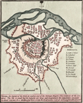 | Details | Luffman, John | 1800 |
| Fine Antique Plan of Vienna, Austria |
|
Luffman, John |
|
| 1800 |
| LOC:77 |
| $180.00 | Luffman--John | Fine-Antique-Plan-of-Vienna--Austria | Scarce and attractive antique copper-plate engraved map of Vienna, Austria by John Luffman. Luffman describes Vienna as: ". . . The capital of the Circle of Austria and of the German Empire: The residence of the Emperor. The city is small but the suburbs are large and magnificent, the population amounts to about 300,000. It is 565 miles E. of Paris and 680 E.S.E. of London…"
<br></br>
Key locations noted by Luffman include the Danube River, Nusdorf Gate, St. Mark's Gate, Lerchenfeld Gate, the Arsenal, the Hospital, the Carmelites, and the Cathedral.
<br></br>
From "Luffman's Select Plans of the Principal Cities, Harbors, Forts etc. in the World". Engraved and published by John Luffman, No. 28 Little Bell Alley, Coleman Street, October 1, 1800. Volume 1 . Number 63.
<br></br> |
| 5287 | 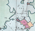 | Details | Luffman, John | 1801 |
| Port Louis, France harbor chart engraved for Luffman's Select Plans |
|
Luffman, John |
|
| 1801 |
| LOC:7 |
| $185.00 | Luffman--John | Port-Louis--France-harbor-chart-engraved-for-Luffman-s-Select-Plans | Copper-plate engraved chart or map of Port Louis, France. Louis XIV established the French East India Company or Compagnie française pour le commerce des Indes orientales, at Port-Louis in 1664. in 1769, unable to maintain itself financially, the Company was liquidated.
<br></br>
The chart shows the walled town of Port Louis and the Citadel, now home to the Musée de la Compagnie des Indes. Along the roadstead: St. Catherines, two un-named forts, the Island of St. Michael; Querco Point and Bangor Point.
<br></br>
Description at the bottom reads in part:
<div class="indenttextblock">
"Port Louis, a town & fort in the Dept. of Morbihan 2 miles S. of l'Orient and 282 W. by S. of Paris."
</div>
<br />
From "Luffman's Select Plans of the Principal Cities, Harbors, Forts etc. in the World". Engraved and published by John Luffman, No. 28 Little Bell Alley, Coleman Street, October 1, 1801. Vol II. Number 25.
<br></br> |
| 5288 | 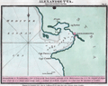 | Details | Luffman, John | 1801 |
| Chart of Iskenderun (Alexandretta) engraved for Luffman's Select Plans |
|
Luffman, John |
|
| 1801 |
| LOC:2 |
| $275.00 | Luffman--John | Chart-of-Iskenderun-(Alexandretta)-engraved-for-Luffman-s-Select-Plans | Harbor chart for Iskenderun (Alexandretta) on Turkey's east Mediterranean Coast. Noted features include: Mount Caillo, Baylassa, Cape Porco, and Cape Canzin.
<br></br>
Description at the bottom reads in part:
<div class="indenttextblock">
"Alexandretta or Scanderoon, a port of Syria at the North Eastern extremity of the Mediterranean Sea, it is the sea port of Aleppo from which city it is distant about seventy miles."
</div>
<br />
From "Luffman's Select Plans of the Principal Cities, Harbors, Forts etc. in the World". Engraved and published by John Luffman, No. 28 Little Bell Alley, Coleman Street, September 1, 1801. Vol II. Number 33.
[ Scanderoon ]. |
| 3691 | 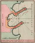 | Details | Luffman, John | 1801 |
| Antique plan of the harbor at Rhodes, Greece for Luffman's Select Plans |
|
Luffman, John |
|
| 1801 |
| LOC:77 |
| $230.00 | Luffman--John | Antique-plan-of-the-harbor-at-Rhodes--Greece-for-Luffman-s-Select-Plans | Fine copper-plate engraved plan of the harbor at Rhodes, Greece, the largest of Greece's Dodecanese islands. Shows the two jetties at the harbor entrance each protected by two fortified positions. Along with the city walls, depth soundings and anchorages are clearly marked. Luffman notes: <div class="indenttextblock">
"The harbour of Rhodes is situated in the island of the same name in the Mediterranean Sea. Here stood the famous colossal statue of Apollo. The city is Lat 36.24 N Long 28.12 E of London."
</div>
</BR>
<br></br>
From "Luffman's Select Plans of the Principal Cities, Harbors, Forts etc. in the World". Engraved and published by John Luffman, No. 28 Little Bell Alley, Coleman Street. London. March 1, 1801. Volume II, Number 1.
<br></br>
Luffman also provided similar engravings to this at about the same time for J.T. Serres' "The Little Sea Torch: or, True Guide for Coasting Pilots." Serres translated the Little Sea Torch from an earlier illustrated coasting pilot guide, based on Bougard's "Le petit flambeau de la mer", first published in 1684.
<br></br>
John Luffman (1751-1821) began his career as an engraver, producing a very large and fine map of Antigua, where he had resided in 1787 and 1789. That map was published by Luffman to accompany his 'A Brief Account of the Island of Antigua', 1788." Luffman shared the same sad fate as many publishers and was declared bankrupt on 9th March, 1793. Moving forward Luffman was more cautious and produced small format atlases and handy-sized maps of the theatres of war, principal towns and cities and battle-plans relating to the Wars of the French directorate and the subsequent Napoleonic War. |
| 5286 |  | Details | Luffman, John | 1801 |
| Chart of Leghorn, Italy (Livorno) engraved for Luffman's Select Plans |
|
Luffman, John |
|
| 1801 |
| LOC:7 |
| $225.00 | Luffman--John | Chart-of-Leghorn--Italy--(Livorno)-engraved-for-Luffman-s-Select-Plans | Copper-plate engraved chart or map of the port of Livorno (Leghorn), Italy. In the 16th-century Leghorn was under the control of the Medici family who greatly improved the harbor. Leghorn was free and neutral from 1691 until 1867 when it was incorporated into the nation of Italy.
<br></br>
The chart shows the Mellora Shoal and Mellora Tower west of Livorno; the Tower of Marzocco, the Colombrone River, and numerous hydrographic features including anchorages, navigation hazards, and depth soundings.
<br></br>
Description at the bottom reads in part:
<div class="indenttextblock">
"The Port of Leghorn is a free port in the Mediterranean Sea, in the Dominions of the Grand Duke of Tuscany in Italy. It is a place of considerable trade; 46 miles west of Florence & 145 miles North West of Rome."
</div>
<br />
From "Luffman's Select Plans of the Principal Cities, Harbors, Forts etc. in the World". Engraved and published by John Luffman, No. 28 Little Bell Alley, Coleman Street, January 1, 1801. Vol 1. Number 73.
<br></br> |
| 1216 | 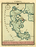 | Details | Luffman, John | 1801 |
| Plan of Corfu engraved for Luffman's Select Plans |
|
Luffman, John |
|
| 1801 |
| LOC:2 |
| $160.00 | Luffman--John | Plan-of-Corfu-engraved-for-Luffman-s-Select-Plans | Copper-plate engraved plan or map of the island of Corfu, Greece by John Luffman. Corfu is a Greek island in the Ionian Sea. The northeastern edge of Corfu lies off the coast of Sarandë, Albania, separated by straits varying in width from 2 to 14 miles.
<br></br>
The town of Corfu is depicted as surrounded by a Vauban-style fortified wall; it's harbor protected by a long 'mole' or breakwater. Coverage includes Castle St. Angelo, Porto Sideri, Porto Timoni, Porto Euripo, Porto Spilea, Formiche, Gudia Island, Condilonisi, and the Valley of St. Stefano.
<br></br>
Description at the bottom reads in part:
<div class="indenttextblock">
"<b>Corfu</b>, anciently Depane, Scheria, Phoeacia, and Corcyra is situated in the mouth of the Gulf of Venice, in the Mediterranean Sea. It was taken from the Venetians by Buonaparte in 1798 and by the Turks and Russians in 1799."
</div>
<br />
From "Luffman's Select Plans of the Principal Cities, Harbors, Forts etc. in the World". Engraved and published by John Luffman, No. 28 Little Bell Alley, Coleman Street, October 1, 1801. Number 15.
<br></br> |
| 3690 | 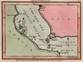 | Details | Luffman, John | 1801 |
| Antique map of the Red Sea and Bab al-Mandab Strait for Luffman's Select Plans |
|
Luffman, John |
|
| 1801 |
| LOC:77 |
| $230.00 | Luffman--John | Antique-map-of-the-Red-Sea-and-Bab-al-Mandab-Strait-for-Luffman-s-Select-Plans | Fine copper-plate engraved plan of the Bab al-Mandab Strait (Babel Mandel) at the mouth of the Red Sea. Includes the villages of Assab (Asab), Eritrea and Mocha (Moka), in Yemen. The Bab al-Mandab Strait connects the Red Sea to the Gulf of Aden. Other key features noted on the map include Purim (Mehta) Island, Cape Rasel, Pilot Island or Robands and the Lofty Islands.
<br></br>
From "Luffman's Select Plans of the Principal Cities, Harbors, Forts etc. in the World". Engraved and published by John Luffman, No. 28 Little Bell Alley, Coleman Street. London. November 1, 1801. Volume II, Number 53.
<br></br>
Luffman also provided similar engravings to this at about the same time for J.T. Serres' "The Little Sea Torch: or, True Guide for Coasting Pilots." Serres translated the Little Sea Torch from an earlier illustrated coasting pilot guide, based on Bougard's "Le petit flambeau de la mer", first published in 1684.
<br></br>
John Luffman (1751-1821) began his career as an engraver, producing a very large and fine map of Antigua, where he had resided in 1787 and 1789. That map was published by Luffman to accompany his 'A Brief Account of the Island of Antigua', 1788." Luffman shared the same sad fate as many publishers and was declared bankrupt on 9th March, 1793. Moving forward Luffman was more cautious and produced small format atlases and handy-sized maps of the theatres of war, principal towns and cities and battle-plans relating to the Wars of the French directorate and the subsequent Napoleonic War. |
| 4852 | 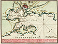 | Details | Luffman, John | 1801 |
| Antique British chart of Toulon Harbor, France |
|
Luffman, John |
|
| 1801 |
| LOC:13 |
| $250.00 | Luffman--John | Antique-British-chart-of-Toulon-Harbor--France | Antique large scale chart of Toulon Harbor, France by John Luffman from 1801.
<br><br>
A fine plan of the Little Road and the Great Road of Toulon. Depth soundings and marked anchorages fill the chart on the way south to the Mediterranean Sea. Shows numerous defensive features including Fort St. Louis, Malgue Fort, numerous towers, and two powder magazines (outside town walls).
<br></br>
As described by Luffman: <div class="indenttextblock">
"Toulon Harbour. The mole of this celebrated harbour was begun by Henry 4 and finished by Louis 13. The arsenal A. and the new port or harbor for Men of War B. were constructed by Louis 14. C. shews the harbour for merchant ships, coasters, etc. Toulon City is 217 miles south-east of Paris. Latitude 43.7 North. Longitude 5.37 East from London."
</div>
</BR>
From "Luffman's Select Plans of the Principal Cities, Harbors, Forts etc. in the World". Engraved and published by John Luffman, No. 28 Little Bell Alley, Coleman Street, Cheapside, London. September 1, 1801. Volume I, Number 9.
<br></br>
John Luffman (1751-1821) began his career as an engraver, producing a very large and fine map of Antigua, where he had resided in 1787 and 1789. That map was published by Luffman to accompany his 'A Brief Account of the Island of Antigua', 1788." Luffman shared the same sad fate as many publishers and was declared bankrupt on 9th March, 1793. Moving forward Luffman was more cautious and produced small format atlases and handy-sized maps of the theatres of war, principal towns and cities and battle-plans relating to the Wars of the French directorate and the subsequent Napoleonic War. |
| 4850 | 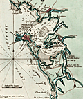 | Details | Luffman, John | 1801 |
| Antique map of Cadiz Harbour, Spain |
|
Luffman, John |
|
| 1801 |
| LOC:0 |
| $250.00 | Luffman--John | Antique-map-of-Cadiz-Harbour--Spain | Fine copper-plate engraved plan of Cadiz Harbor, Spain not far from the Strait of Gibraltar. Includes Rota, Porto St. Maria, Fort Saint Sebastien, Puntal Road, Carraca, and Chiclana. As described by Luffman: <div class="indenttextblock">
"Cadiz, by the Phoenecians called 'Gadir' and by the Romans 'Gades', is situated in the province of Andalusia & its harbour the best in Old Spain. It was originally built by the Tyrians and possessed successively by the Carthaginians, Romans, and Moors, the latter were dispossessed in 1260. It is 42 miles N.W. of Gibraltar. Lat. 36.30 N. Lon. 6.40 W."
</div>
</BR>
From "Luffman's Select Plans of the Principal Cities, Harbors, Forts etc. in the World". Engraved and published by John Luffman, No. 28 Little Bell Alley, Coleman Street, Cheapside, London. July 1, 1801. Volume I, Number 1.
<br></br>
Luffman also provided similar engravings to this at about the same time for J.T. Serres' "The Little Sea Torch: or, True Guide for Coasting Pilots." Serres translated the Little Sea Torch from an earlier illustrated coasting pilot guide, based on Bougard's "Le petit flambeau de la mer", first published in 1684.
<br></br>
John Luffman (1751-1821) began his career as an engraver, producing a very large and fine map of Antigua, where he had resided in 1787 and 1789. That map was published by Luffman to accompany his 'A Brief Account of the Island of Antigua', 1788." Luffman shared the same sad fate as many publishers and was declared bankrupt on 9th March, 1793. Moving forward Luffman was more cautious and produced small format atlases and handy-sized maps of the theatres of war, principal towns and cities and battle-plans relating to the Wars of the French directorate and the subsequent Napoleonic War. |
| 4823 | 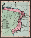 | Details | Luffman, John | 1801 |
| Antique map of Brazil engraved for Luffman's Select Plans |
|
Luffman, John |
|
| 1801 |
| LOC:77 |
| $230.00 | Luffman--John | Antique-map-of-Brazil-engraved-for-Luffman-s-Select-Plans | Fine original copper-plate engraved map of Brazil, on the South American continent, by John Luffman, 1801.
<br></br>
Antique map from Luffman's "<b>Select Plans of the Principal Cities, Harbors, Forts etc. in the World</b>". Engraved and published by John Luffman, No. 28 Little Bell Alley, Coleman Street. London. May 1, 1801. Volume II.
<br></br>
Luffman also provided engravings for J.T. Serres' "The Little Sea Torch: or, True Guide for Coasting Pilots." Serres translated the Little Sea Torch from an earlier illustrated coasting pilot guide, based on Bougard's "Le petit flambeau de la mer", first published in 1684.
<br></br>
<b>John Luffman (1751-1821)</b> began his career as an engraver, producing a very large and fine map of Antigua, where he had resided in 1787 and 1789. That map was published by Luffman to accompany his 'A Brief Account of the Island of Antigua', 1788." Luffman shared the same sad fate as many publishers and was declared bankrupt on 9th March, 1793. Moving forward Luffman was more cautious and produced small format atlases and handy-sized maps of the theatres of war, principal towns and cities and battle-plans relating to the Wars of the French directorate and the subsequent Napoleonic War. |
| 1344 | 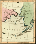 | Details | Luffman, John | 1802 |
| Behrings Strait and Alaska engraved for Luffman's Select Plans |
|
Luffman, John |
|
| 1802 |
| LOC:3 |
| $280.00 | Luffman--John | Behrings-Strait-and-Alaska-engraved-for-Luffman-s-Select-Plans | Scarce and attractive antique copper-plate engraved map of the Bering (Behring) Strait and Gulf of Alaska by John Luffman. This small but fine map extends past 70 degrees north latitude. The Bering Strait is a narrow body of water that links the Arctic Ocean with the Bering Sea and separates the continents of Asia and North America ( Alaska ) at their closest point. Some portions of the Alaska and Asia coasts not well explored at the time are shown with dotted lines, reflecting the uncertainty about their geography.
<br></br>
Key locations noted by Luffman include Bristol Bay, Cook River, Cape Prince of Wales, Cape Stephens, Cape Mulgrave, Cape Lisburn, Round Island, Norton Sound, and Trinity Island at the southern tip of the Kodiak Archipelago (not shown in its entirety).
<br></br>
Bering's strait averages 100 to 165 feet in depth and at its narrowest point is about 53 miles wide. About 20,000 years ago, during the Ice Age, the sea level fell by several hundred feet, making the strait into a land bridge between Asia and North America, over which the migration of plants and animals and humans occurred.
<br></br>
From "Luffman's Select Plans of the Principal Cities, Harbors, Forts etc. in the World". Engraved and published by John Luffman, No. 28 Little Bell Alley, Coleman Street, February, 1802. Volume II; Number 67.
<br></br> |
| 4873 | 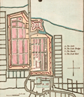 | Details | Luffman, John | 1802 |
| Antique map of Batavia |
|
Luffman, John |
|
| 1802 |
| LOC:77 |
| $280.00 | Luffman--John | Antique-map-of-Batavia | Antique map of Batavia (Jakarta, Indonesia) by John Luffman. |
| 933 | 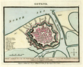 | Details | Luffman, John | 1803 |
| Antique plan of Ostend, Belgium |
|
Luffman, John |
|
| 1803 |
| LOC:7 |
| $145.00 | Luffman--John | Antique-plan-of-Ostend--Belgium | Small, neat, antique plan of the Belgian coastal town of <b>Ostend</b> shown surrounded by water on 3 sides and by Vauban-style defensive walls with numerous bastions. Published 1804 by <b>John Luffman</b> in "Select Plans of the Principal Cities, Harbours, Forts etc. in the World." Luffman (1776-1820) was a London goldsmith, engraver, and publisher.
<br></br>
Description of the town at bottom reads: <div class="indenttextblock">"Ostend, a considerable port and city of the French Republic in the department of Lys. It is 22 miles NE of Dunkirk and 10 W. of Bruges. Latitude 51.14 N. Longitude 5.0 E. of London." </div>
</br>
Luffman shows thick, double defensive walls around the town with a street plan. Includes the harbor at the east end and Key Creek to the south. A legend at left is keyed to several important locations including: the town house; the great church; St. Martins; the great square; the new market, the key gate; the west gate; the beast market; and coffers (piers). The plan is drawn at low tide with the coffers high above a large expanse of exposed beach.
<br></br>
Publisher's attribution at bottom margin reads: <div class="indenttextblock">Engraved and Published Nov 1, 1803 by J. Luffman, No. 28 Little Bell Alley, Coleman Street, London.</div> |
| 932 | 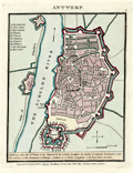 | Details | Luffman, John | 1804 |
| Antique plan of Antwerp, Belgium |
|
Luffman, John |
|
| 1804 |
| LOC:7 |
| $200.00 | Luffman--John | Antique-plan-of-Antwerp--Belgium | <div class="indenttextblock">"Antwerp, fine city of France in the department of the Scheldt; heretofore the capital of the Austrian Brabant, and once the mistress of the commerce of Europe. Latitude 51.13 North. Longitude 4.29 East from London." </div> So reads the description of this neat antique plan of the walled town of <b>Antwerp, Belgium</b>. Published 1804 by <b>John Luffman</b> in "Select Plans of the Principal Cities, Harbours, Forts etc. in the World." Luffman (1776-1820) was a London goldsmith, engraver, and publisher.
<br></br>
Luffman shows double defensive walls around the rather large town with a street plan. Includes the Citadel at the southern end of town and two forts across the Scheldt river along the "Dyke of Flanders".
A legend at left is keyed to several important locations including: The Cathedral; Town House; Fort Isabella; St. James; St. George; St. Walburg; St. Andren; St. Michael; the Exchange; and Meer Street. Two additional forts are identified as Terre de Flanders and Fort St. Laurent.
<br></br>
Publisher's attribution at bottom margin reads: <div class="indenttextblock">"Engraved and Published Feb 1, 1804 by J. Luffman, No. 28 Little Bell Alley, Coleman Street, London."</div> |