| | Thumbnail | | Creator | Date | Title / Author / Date / Location | Price | | | Description |
| 1375 | 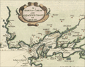 | Details | Moll, Herman | 1695 |
| Antique map of Belle Isle, Brest, in Brittany France |
|
Moll, Herman |
|
| 1695 |
| LOC:7 |
| $200.00 | Moll--Herman | Antique-map-of-Belle-Isle--Brest--in-Brittany-France |
Attractive antique copper-engraved map by Moll of the lower tip of Brittany (Bretagne), France from roughly the Pointe de Corsen, past Pointe de Kermorvan, le Conquet, Brest, and Crozon. This scarce map is titled "The Marquisate and Government of Bell-Isle Divided into its Four Parishes of the Palace, Bangor, Lomaria, and Sauzon."
<br></br>
One unusual feature of this map is the large number of mills the cartographer identifies, perhaps because their high elevation, like that of church steeples, would have provided coastal mariners with navigational reference points ashore. Together Moll's emphasis on features of great height and the rhumb lines with compass rose, suggest the original inspiration for this map is derived from a nautical chart. Verso with map of Belle Isle, France in the Sea of Bretagne. |
| 1091 | 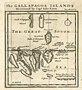 | Details | Moll, Herman | 1699 |
| First printed map to focus on the Galapagos Islands |
|
Moll, Herman |
|
| 1699 |
| LOC:0 |
| $0.00 | Moll--Herman | First-printed-map-to-focus-on-the-Galapagos-Islands | SOLD<br></br>
Very scarce map of the Galapagos Islands and the earliest printed map of the Galapagos. |
| 1092 |  | Details | Moll, Herman | 1699 |
| First printed map of Peypses or Pepys Island. |
|
Moll, Herman |
|
| 1699 |
| LOC:5 |
| $0.00 | Moll--Herman | First-printed-map-of-Peypses-or-Pepys-Island- | SOLD <br></br>Four scarce views on one sheet based on a manuscript maps drawn by <b>William Ambrosia Cowley</b>. The views are of: the Island Of John Ferdinando; the perhaps fictitious Peypses Island; Nutmeg Island; and the Cape of Good Hope, at the southern tip of the African continent.
<br></br>
Cowley was sailing master of a pirate ship captained by John Eaton in 1684 when they made landfall at the Galapagos Islands in the Pacific Ocean. Cowley's narrative of the voyage entitled 'Cowley's Voyage Around the Globe' was published in the 'COLLECTION OF ORIGINAL VOYAGES' by William Hacke from London in 1699.
<br></br>
In Cowley's manuscript journal he recorded his landing at an island he called <b>Pepyes Island</b>:
<div class="indenttextblock">
"We held our Course S. W. till we came into the lat. of 47 deg. where we saw Land; the same being an Island not before known, lying to the Westward of us. It was not inhabited, and I gave it the Name of Pepys Island. We found it a very commodious place for Ships to water at and take in Wood, and it has a very good Harbour, where a thousand sail of Ships may safely ride: Here is great plenty of Fowls, and we judge, abundance of Fish, by reason of the Grounds being nothing but Rocks and Sands. "
</div>
Of John Ferdinando (Isla Juan Fernandez or Más a Tierra) Cowley wrote:
<div class="indenttextblock">
"Capt. Bartholomew Sharpe was here in the Year 1680, and finding no People on it, he called it Queen Catherines Island; and when he sailed away did leave one Man on shoar, which was a Mosquito Indian, who lived here alone near 4 Years. … there being several of our Ships Company who were at the leaving of this Indian there by Capt. Sharpe, and among others Capt. Edmond Cook and Mr. William Dampier". (Cowley, W.A., "Cowley's Voyage Around the Globe" <a href="http://www.galapagos.to/TEXTS/COWLEY.HTM#GalapagosSection" target="_blank">Internet</a>)
</div> |
| 3599 | 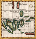 | Details | Moll, Herman | 1699 |
| First printed map focused on the Galapagos Islands (French ed.) |
|
Moll, Herman |
|
| 1699 |
| LOC:0 |
| $0.00 | Moll--Herman | First-printed-map-focused-on-the-Galapagos-Islands-(French-ed-) | SOLD <br></br>
French language version of this scarce map of the Galapagos Islands which is the <b>earliest printed map of the Galapagos</b>. This small antique engraved map was based on a manuscript map drawn by <b>William Ambrosia Cowley</b>. Cowley was sailing master of a pirate ship captained by John Eaton in 1684 when they made landfall at the Galapagos Islands in the Pacific Ocean. Cowley's narrative of the voyage- 'Cowley's Voyage Around the Globe' was published in English in the 'COLLECTION OF ORIGINAL VOYAGES' by William Hacke from London in 1699.
<br></br>
In Cowley's manuscript journal he recorded his first observations of the Galapagos:
<div class="indenttextblock">
"Then we came to an Anchor in a very good Harbour, lying toward the Northernmost end of a fine Island, under the Equinoctial Line: Here being great plenty of Provisions, as Fish, Sea and Land Tortoises, some of which weighed at least 200 Pound weight, which are excellent good Food. Here are also abundance of Fowls, viz. Flemingoes and Turtle Doves; the latter whereof were so tame, that they would often alight upon our Hats and Arms, so as that we could take them alive, they not fearing Man, until such time as some of our Company did fire at them, whereby they were rendered more shy." (Cowley, W.A., "Cowley's Voyage Around the Globe" <a href="http://www.galapagos.to/TEXTS/COWLEY.HTM#GalapagosSection" target="_blank">Internet</a>)
</div>
<br>
<b>Cowley's Names of the Galapagos Islands from the English Edition </b>
<div class="indenttextblocksingle">
<ul style="list-style-type: circle;">
<li>King Charles's Island
<li>Crossman's Island
<li>Brattles Island
<li>Sir Anthony Dean's Island
<li>Eure's Island
<li>Dassigney's Island
<li>Bindlos's Island
<li>Duke of York's Island
<li>Duke of Norfolk's Island
<li>Duke of York's Island
<li>Duke of Albemarle's Island
<li>Sir John Narborough's
<li>Cowley's enchanted Island
<li>Earl of Abington's Island
</ul>
</div> |
| 3637 | 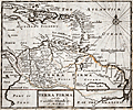 | Details | Moll, Herman | 1701 |
| Moll's fine map of Terra Firma or Northern South America |
|
Moll, Herman |
|
| 1701 |
| LOC:5 |
| $0.00 | Moll--Herman | Moll-s-fine-map-of-Terra-Firma-or-Northern-South-America | SOLD <br></br>Herman Moll's scarce map of Terra Firma and the Caribbean Islands. No sale of this item is recorded in AMPR in the last 17 years.
<br></br>
Covers from Cuba south as far as the Amazon River. Includes the modern day nations of Colombia, Venezuela, Ecuador, Guyana and Brazil. Moll notes the city of Manoa and the location of El Dorado (lost city of gold) west of the Prime or Parima Lake.
<br></br>
During Spain's New World Empire, its mainland coastal possessions bordering the Caribbean Sea and the Gulf of Mexico were referred to collectively as the Spanish Main. The southern portion of these coastal possessions were known as the Province of Tierra Firme ( Terra Firma ), or the "Mainland province".
(Source Wikipedia. https://en.wikipedia.org/wiki/Province_of_Tierra_Firme)
<br></br>
From Moll's "A System of Geography: Or A New and Accurate Description of the Earth In all its Empires, Kingdoms and States" (London), 1701. |
| 2482 | 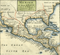 | Details | Moll, Herman | 1709 |
| Mexico, or New Spain With Guadalajara, Guatemala, and Florida |
|
Moll, Herman |
|
| 1709 |
| LOC:3 |
| $500.00 | Moll--Herman | Mexico--or-New-Spain-With-Guadalajara--Guatemala--and-Florida | A map dealer's map!! I love it!
<br></br>
Hermans Moll's classic map of the United States, Caribbean, and Central America. Moll has divided the area into the four provinces of Mexico, Guadalajara Guatemala, and Florida. Pacific Ocean is labeled "The Great South Seas"; the Gulf of Mexico is sub-titled "the Bay of Mexico". Beginning of Chapter VII. Page 214. English text on verso. |
| 6773 | 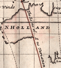 | Details | Moll, Herman | 1715 |
| Moll's world map of with monsoons and trade winds |
|
Moll, Herman |
|
| 1715 |
| LOC:89 |
| $400.00 | Moll--Herman | Moll-s-world-map-of-with-monsoons-and-trade-winds | Increasingly scarce map of the world by Herman Moll ca. 1715 covering a large area from 50 degrees north to 50 degrees south of the Equator. The map, on Mercator's projection is centered on "the Great South Sea", or Pacific Ocean, and Moll's incomplete outlines for New Zealand, Australia, and Tasmania reflect the uncertain state of geographical knowledge in the early eighteenth century.
<br><br>
Moll's maps touching on compass variation and wind patterns, especially the trade winds, stand out as significant contributions to cartography and navigation. Moll tried to visualize the concept of global atmospheric circulation, making use of the contemporary understanding of trade winds and monsoons. Monsoon winds are seasonal wind patterns that occur over various regions, most notably in South and Southeast Asia, where they cause the well-known monsoon rains. As Moll explains in his note at upper left:
<br><br>
<div class="indenttextblocksingle">
"Note that the Arrows among the Lines shew the Course of these General & Coasting Winds, and the Arrows in the void Spaces shew the Course of the Shifting TRADE-WINDS, and the abbreviations Sept. &c. Shew the Times of the Year when such Winds blow".
</div><br>
<div id="0" align="center">
<a title=""></a>
<img id="6773" src="/ZoomifyImages/SC_6773/SC_6773_detail_1.jpg" alt="Detail of the East Indies from Moll's Map of Monsoon and Trade Winds." width="340"/> <br><br> <font size="-2">Monsoon and Trade Winds in The East Indies. Moll, 1715.</font>
</div><br>
On this map, Moll represented the trade winds – the predictable east-west wind patterns in the tropical latitudes – using arrows. Knowing the direction of the trade winds at specific times of the year, was crucial to understanding how to plan routes for ships involved in trade and exploration. This information was invaluable to the burgeoning Atlantic economies, particularly in the context of the Atlantic triangular trade. |
| 3673 | 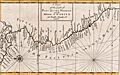 | Details | Moll, Herman | 1720 |
| Antique Chart of the west coat of Panama, Colombia, Ecuador, and Peru |
|
Moll, Herman |
|
| 1720 |
| LOC:77 |
| $250.00 | Moll--Herman | Antique-Chart-of-the-west-coat-of-Panama--Colombia--Ecuador--and-Peru | Compact antique chart of the west coast of Panama, Colombia, Equator, and Peru by Herman Moll |
| 893 | 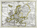 | Details | Moll, Herman | 1736 |
| Europe and the Near East |
|
Moll, Herman |
|
| 1736 |
| LOC:0 |
| $0.00 | Moll--Herman | Europe-and-the-Near-East | SOLD
<br></br>
Antique map of Europe, Greenland, Turkey, Persia, and North Africa by Herman Moll. Note for Groenland (Greenland) states: "Ice and Mountains covered with snow." Geographic relief is depicted in a simple pictorial style. This old map of Europe is from the 3rd edition of Moll's "Atlas Minor: or a New and Curious Set of Sixty-two Maps", published for Thomas and John Bowles in 1736. |
| 1353 | 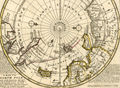 | Details | Moll, Herman | 1736 |
| Original Antique Polar Map of the North Pole |
|
Moll, Herman |
|
| 1736 |
| LOC:1 |
| $425.00 | Moll--Herman | Original-Antique-Polar-Map-of-the-North-Pole | Fine original antique 18th-century polar map of the <b>North Pole</b> annotated with observations and facts regarding early exploration of the north polar region. This striking polar projection shows Iceland, Greenland, Spitsbergen, Nova Zembla, portions of North America and Northern Europe. Text blocks at right and left detail the sun's movement at high latitudes and the explorations of the polar region by Frobisher, Davis and others
<br></br>
Printed for Tho: Bowles next ye Chapter House in St. Pauls Church Yard, & John Bowles at the Black Horse in Cornhill, London. |
| 892 | 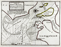 | Details | Moll, Herman | 1736 |
| Antique Chart of Port Royal Harbor, South Carolina |
|
Moll, Herman |
|
| 1736 |
| LOC:3 |
| $425.00 | Moll--Herman | Antique-Chart-of-Port-Royal-Harbor--South-Carolina | This antique chart of <b>Port Royal Sound</b>, drawn by Herman Moll before 1732, is the earliest obtainable large-scale chart focused on the Port Royal / Beaufort, South Carolina area and one of the earliest to name <b>Hilton Head</b>. With locations identified for two proposed forts guarding the main channel to "Bauford Town" (Beaufort), which was located by Moll on Parris Island ("Port Royal Island"). Other noted features include St. Helena Island, with Phillips Point and St. Michaels Head. Numerous soundings and sandbars are indicated.
<br></br>
Moll added this description of the area below the title block: <div class="indenttextblock">"Port Royal River lies 20 Leagues from Ashley River SW it has a bold entrance 19 or 20 foot at low-water. The Harbor is large, safe, and commodious and runs into ye best country in Carolina. Here ye air is always cleer and agreeable to Europian constitutions".</div>
</br>
This old map of Port Royal, Hilton Head, and Beaufort S.C. is from the 3rd edition of Moll's "Atlas Minor: or a New and Curious Set of Sixty-two Maps", published for Thomas and John Bowles in 1736. |
| 5209 |  | Details | Moll, Herman | 1744 |
| Map of the North Pole by Herman Moll 1744 |
|
Moll, Herman |
|
| 1744 |
| LOC:13 |
| $325.00 | Moll--Herman | Map-of-the-North-Pole-by-Herman-Moll-1744 | Fine original antique 18th-century polar map of the North Pole by Herman Moll. This scarce map is annotated with observations and facts regarding early exploration of the north polar region. Perhaps this is an unrecorded fifth state of the map as the "Vol 1. p. 714" found at upper left in the fourth state has been largely effaced and only a faint hint of the graved lines remain visible. The number " 2 " at upper right is clearly visible.
<br></br>
This striking polar projection shows Iceland, Greenland, Spitsbergen, Nova Zembla, portions of North America and Northern Europe. Text blocks at right and left detail the sun's movement at high latitudes and the explorations of the polar region by Frobisher, Davis and others
<br></br>
Published in London in "Thomas Salmon's Modern History: or the Present State of All Nations." Printed for Tho: Bowles next the Chapter House in St. Pauls Church Yard, & John Bowles at the Black Horse in Cornhill, London. |