| | Thumbnail | | Creator | Date | Title / Author / Date / Location | Price | | | Description |
| 5334 | 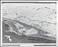 | Details | National Aeronautics and Space Administration | 1966 |
| NASA glossy publicity photo of J . F. K. Space Center map |
|
National Aeronautics and Space Administration |
|
| 1966 |
| LOC:11 |
| $100.00 | National-Aeronautics-and-Space-Administration | NASA-glossy-publicity-photo-of-J---F--K---Space-Center-map | An original NASA unclassified glossy black and white publicity photograph of a NASA birdseye view map of the John F. Kennedy Space Center and the surrounding area in eastern and central Florida. Dated on verso to 8/8/66.
<br></br>
The photograph shows a map, apparently tacked to a bulletin board, ranging in coverage as far as Orlando, Oak Hills, and Eau Galle, Florida. Key points of interest shown include: McCoy Air Force Base, Patrick Air Force Base, Cocoa Beach, the St. Johns River, Indian River, Banana River, and Mosquito Inlet. At the lower left corner is a key or context map showing the location of the map relative to the entire state of Florida.
<br></br>
When the photo was published in August, 1966 NASA was winding down the last two of 19 Gemini program missions to place a capsule with two astronauts into Earth orbit. The final two launches in the Gemini program were:
<br></br>
<div class="indenttextblocksingle">
<ul style="list-style-type: circle;">
<li>Pete Conrad and Richard Gordon. Launched September 12, 1966</li>
<li>Jim Lovell and Buzz Aldrin. Launched November 11, 1966</li>
</ul>
</div> |