| | Thumbnail | | Creator | Date | Title / Author / Date / Location | Price | | | Description |
| 6500 | 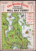 | Details | Page, Peter Hugh | 1936 |
| Rare pictorial map of Victoria, British Columbia with Ferry Routes |
|
Page, Peter Hugh |
|
| 1936 |
| LOC:78 |
| $350.00 | Page--Peter-Hugh | Rare-pictorial-map-of-Victoria--British-Columbia-with-Ferry-Routes | Rare pictorial auto map of Victoria, Vancouver Island, British Columbia, Canada featuring the Mill Bay Ferry route as an element of the Scenic Circle auto route. The map features numerous small cartoonish drawings of local activities including golfing, hunting, fishing, gardening, and horse racing. No holdings of this rare pictorial auto route map are found anywhere else online, nor any record of sales. Dated within to 1936.
<br><br>
Locations noted on the map include Telegraph Beach, Victoria Golf Club, James Island, Sidney, Sidney Island, Esquimalt Harbor, and Cordova Bay.
<br><br>
On card stock, this unusual piece of cartographic ephemera includes the original string hanger still attached through two punched holes.
<br><br>
Recto with departure times for the Mill Bay Ferry from both Malahat and from Brentwood. Verso with a photo of the ferry - M.S. Cascade, an inset smaller-scale sketch map of the Victoria surrounding area, a mileage table, and text on points of interest and suggestions for the Scenic Circle drive.
<div class="indenttextblocksingle">
"Ferry Trip across the placid waters of Saanich Arm, Sport Fishing preserve, where salmon up to 53-lbs. are taken and over fifty species of fish are found. From the Ferry can be seen Senanus Island, an ancient Indian burial ground, Bamberton Cement Works, Brentwood Cottage".
<br>and<br>
"A glance at the Map on the other side will convince you of the ease and simplicity of this Route. You can save MONEY, TIME and reduce your mileage from 83 to 45 by using this convenient connecting link [ferry] between Mr. BUTCHARTS GARNENS and the Famous MALAHAT DRIVE…"
</div> |
| 6469 | 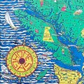 | Details | Page, Peter Hugh | 1936 |
| Fine pictorial maps of British Columbia for Home Gas |
|
Page, Peter Hugh |
|
| 1936 |
| LOC:150 |
| $0.00 | Page--Peter-Hugh | Fine-pictorial-maps-of-British-Columbia-for-Home-Gas | SOLD<br><br>Unrecorded, extraordinary, even spectacular pictorial map of British Columbia for Home Gas. The map was produced by artist Peter Hugh Page toward the end of the Great Depression (1936).
<br><br>
<div class="indenttextblock"><strong>
"Home Gas here offers you a map sensational!! <br>British Columbia is the province shewn. <br>And when you're feeling thoroughly vacational. <br>Pay us a visit and treat the place like home."</strong>
</div><br>
<div id="0" align="center">
<a title="Peter Hugh Page B.C. map details"></a>
<img id="1" src="/ZoomifyImages/SC_6469/SC_6469_details.jpg" alt="Hugh Page B.C. pictorial map details." width="330"/> <br><small>Pictorial B.C. road map details by Peter Hugh Page</small>
</div><br>
Folding brochure (max. 26" x 20") with two similarly attractive smaller pictorial maps (each map 13" x 10") on the verso for Victoria, B.C. and for Vancouver, B.C.
<br><br>
<div id="0" align="center">
<a title="Peter Hugh Page map of Vancouver"></a>
<img id="1" src="/ZoomifyImages/SC_6469/SC_6469_Vancouver.jpg" alt="Hugh Page pictorial map of Vancouver from 1836." width="300"/> <br><small>Pictorial road map of Vancouver, B.C. by Peter Hugh Page</small>
</div><br>
<div id="0" align="center">
<a title="Hugh Page map of Victoria B.C."></a>
<img id="1" src="/ZoomifyImages/SC_6469/SC_6469_Victoria.jpg" alt="Hugh Page pictorial map of Victoria from 1936." width="300"/> <br><small>Pictorial road map of Victoria, B.C. by Peter Hugh Page</small>
</div><br> |
| 6513 | 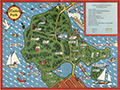 | Details | Page, Peter Hugh | 1940 |
| Fine second edition pictorial map of Stanley Park, Vancouver, British Columbia, Canada |
|
Page, Peter Hugh |
|
| 1940 |
| LOC:78 |
| $350.00 | Page--Peter-Hugh | Fine-second-edition-pictorial-map-of-Stanley-Park--Vancouver--British-Columbia--Canada | Beautiful lithographed pictorial map of Stanley Park, Vancouver, Canada by Peter Hugh Page, ca. 1940. Excellent condition. Second Edition. Shows Prospect Point, Brockton Point, Deadman's Island, Lost Lagoon, Second Beach, Beaver Lake and many other locations and attractions in Stanley Park.
<br><br>
<div align="center">
<a title="Stanley Park Cover"></a>
<img id="3" src="/ZoomifyImages/SC_6513/SC_6513_detail.jpg" alt="Cover from a brochure on Stanley Park, Vancouver, Canada by Peter Hugh Page in 1940." width="175"/> <br><small>Cover from Page's map of Stanley Park</small>
</div><br>
The second edition of Page's map of Stanley Park differs from the first edition in that it includes a depiction of the Lion's Gate Bridge (built 1939) and the label for Siwash Rock is removed. Verso with text about Stanley Park. |
| 7957 | 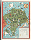 | Details | Page, Peter Hugh | 1941 |
| Rare third edition pictorial map of Stanley Park, Vancouver, British Columbia, Canada |
|
Page, Peter Hugh |
|
| 1941 |
| LOC:41 |
| $350.00 | Page--Peter-Hugh | Rare-third-edition-pictorial-map-of-Stanley-Park--Vancouver--British-Columbia--Canada | Beautiful lithographed pictorial map of Stanley Park, Vancouver, Canada by Peter Hugh Page, ca. 1941. Third Edition of three known editions by Peter Page. Shows Prospect Point, Brockton Point, Deadman's Island, Lost Lagoon, Second Beach, Beaver Lake and many other locations and attractions in Stanley Park.
<br><br>
<div align="center">
<a title="Stanley Park Cover"></a>
<img id="3" src="/ZoomifyImages/SC_6513/SC_6513_detail.jpg" alt="Cover from a brochure on Stanley Park, Vancouver, Canada by Peter Hugh Page in 1940." width="175"/> <br><small>Cover from Page's map of Stanley Park</small>
</div><br>
The third edition of Page's map of Stanley Park differs from the first and second editions in that it includes a label for Siwash Rock; the map shows, for the first time, the Illuminated Fountain built ca. 1936 in Lost Lagoon; and shows the Royal Vancouver Yacht Club site on Deadman's Island. Verso with text about Stanley Park. |